Antequera, Bohol
| Antequera | |
|---|---|
| Municipality | |
|
Antequera, Bohol | |
 Map of Bohol with Antequera highlighted | |
.svg.png) Antequera Location within the Philippines | |
| Coordinates: 9°47′N 123°54′E / 9.78°N 123.9°ECoordinates: 9°47′N 123°54′E / 9.78°N 123.9°E | |
| Country | Philippines |
| Region | Central Visayas (Region VII) |
| Province | Bohol |
| District | 1st district of Bohol |
| Founded | 17 March 1876 |
| Barangay | 21 (see § Barangays) |
| Government [1] | |
| • Type | Sangguniang Bayan |
| • Mayor | Jose Mario Pahang (LP) |
| • Vice mayor | Leo Jadulco |
| • Town Council |
Members
|
| • Representative | Rene Relampagos |
| Area[2] | |
| • Total | 118.6 km2 (45.8 sq mi) |
| Population (2015 census)[3] | |
| • Total | 14,425 |
| • Density | 120/km2 (320/sq mi) |
| • Voter (2016)[4] | 8,691 |
| Time zone | PST (UTC+8) |
| ZIP code | 6335 |
| IDD : area code | +63 (0)38 |
| Income class | 4th class |
| PSGC | 071204000 |
| Website |
www |
Antequera is a 4th municipal income class municipality in the province of Bohol, Philippines,[2] at 18 kilometres (11 mi) north of Tagbilaran. According to the 2015 census, it has a population of 14,425.[3] In the 2016 election, it had 8,691 registered voters.[4]
Popular places of interest in Antequera are the weekly basket market and Mag-Aso Falls. The Mag-Aso falls, whose cascading waters run into natural pools, were greatly altered by the 2013 Bohol earthquake and even more so by flash floods caused by Tropical Storm Seniang in December 2014.[5]
History
The early inhabitants of the area were the Eskaya people, who lived in western Bohol, including the lowlands of Antequera at the present barangay of Viga, from the 7th century until the early 17th century. One legendary Eskaya leader was King Lomod or Tamblot, who raised a revolt against the Spanish conquistadors.[6]
Originally the town was a barangay of Maribojoc known as Agad. Migration from surrounding coastal areas increased the population and created many new sitios. On 17 March 1876, the Governor-General of the Philippines signed a decree that made Agad and all its sitios a new municipality. That same year, the governor of the District of Bohol, Joaquin Bengoechia, enacted the law that finalized the boundaries and appointed its first mayor, Simeon Villas. The new municipality was named after the home town in Spain of Bengoechia.[6]
In 1899, the town of Catigbian was abolished, and the barangays of Caimbang, San Isidro, and Causwagan were added to Antequera. But it lost these barangays, along with half of Cansague, when Catigbian was reestablished on 17 June 1949. On 10 January 1970, the municipality of San Isidro was formed, taking the barangays of Cambansag, Abehilan, and Baunos from Antequera.[6]
Barangays
Antequera comprises 21 barangays:
| PSGC | Barangay | Population | ±% p.a. | ||
|---|---|---|---|---|---|
| 2015[3] | 2010[7] | ||||
| 071204001 | Angilan | 6.6% | 947 | 1,012 | −1.26% |
| 071204002 | Bantolinao | 8.8% | 1,274 | 1,226 | +0.73% |
| 071204003 | Bicahan | 5.3% | 766 | 783 | −0.42% |
| 071204004 | Bitaugan | 4.3% | 622 | 591 | +0.98% |
| 071204005 | Bungahan | 5.8% | 832 | 744 | +2.15% |
| 071204007 | Canlaas | 4.5% | 650 | 736 | −2.34% |
| 071204008 | Cansibuan | 3.9% | 569 | 512 | +2.03% |
| 071204009 | Can‑omay | 3.8% | 543 | 721 | −5.26% |
| 071204010 | Celing | 4.7% | 684 | 671 | +0.37% |
| 071204011 | Danao | 3.3% | 473 | 453 | +0.83% |
| 071204012 | Danicop | 4.6% | 659 | 576 | +2.60% |
| 071204013 | Mag‑aso | 2.8% | 407 | 434 | −1.22% |
| 071204014 | Poblacion | 9.7% | 1,404 | 1,332 | +1.01% |
| 071204015 | Quinapon‑an | 2.0% | 283 | 278 | +0.34% |
| 071204016 | Santo Rosario | 3.7% | 528 | 475 | +2.03% |
| 071204017 | Tabuan | 4.0% | 579 | 584 | −0.16% |
| 071204018 | Tagubaas | 3.2% | 456 | 386 | +3.22% |
| 071204019 | Tupas | 5.9% | 850 | 935 | −1.80% |
| 071204020 | Ubojan | 3.1% | 450 | 529 | −3.03% |
| 071204021 | Viga | 4.1% | 586 | 614 | −0.88% |
| 071204022 | Villa Aurora (Canoc‑oc) | 6.0% | 863 | 889 | −0.56% |
| Total | 14,425 | 14,481 | −0.07% | ||
Demographics
| Population census of Antequera | |||||||||||||||||||||||||
|---|---|---|---|---|---|---|---|---|---|---|---|---|---|---|---|---|---|---|---|---|---|---|---|---|---|
|
| ||||||||||||||||||||||||
| Source: Philippine Statistics Office[3][7][8] | |||||||||||||||||||||||||
In the 2016 election, it had 8,691 registered voters, meaning that 60% of the population are aged 18 and over.[4]
Economy
The primary economic activities are farming, handicraft or cottage industries (especially basket weaving), and carpentry (including bamboo and wood furniture making). Its main agricultural produce comprises coconut, rice, corn, rootcrops, and vegetables.[9]
Total annual income in 2010 was ₱35,960,730
Local government
-
- Vicente Tambis1896–1897
- Julian Calipes1909–1911
- Pedro Omila1912–1915
- Eufemio Morgia1919–1922
- Eustaquio Tambis1922–1925
- Eufemio Morgia1926–1934
- Luis Gementiza1934–1937
- Luis Gementiza1938–1940
- Demetrio Jadulco1940–1941
- Leoncio Paña1943–1945
- Eufemio Morgia1944
- Demetrio Jadulco1945–1946
- Luis Gementiza1946–1951
- Sabino Rebosura1952–1963
- Conrad Vallestero1963
- Isabelito Tongco1964–1992
- Vicente Nunag1987–1988
- Arnulfo Labendia1992
- Felipe Gementiza1992–1998
- Samuel Rebosura1998–2007
- Cecelia Rebosura2007–2010
- Jose Mario Pahang2010–
Gallery
-

Town hall
-
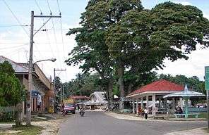
Poblacion
-

Basket market
-

Mag-Aso Falls
-

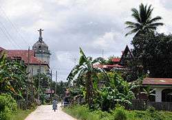
View of church
References
- ↑ "Municipality". Quezon City, Philippines: Department of the Interior and Local Government. Retrieved 31 May 2013.
- 1 2 "Municipal: Antequera, Bohol". PSA. Philippines: National Statistical Coordination Board. Retrieved 8 January 2016.
- 1 2 3 4 "Region VII (CENTRAL VISAYAS)". Census of Population (2015): Total Population by Province, City, Municipality and Barangay (Report). PSA. Retrieved 20 June 2016.
- 1 2 3 "2016 National and Local Elections Statistics". Commission on Elections. 2016.
- ↑ "Waterfalls you must see in Bohol". boholchronicle.com.ph. The Bohol Chronicle. April 26, 2015. Retrieved 13 May 2016.
- 1 2 3 Russell Glenn L. Lomotos. "History of Antequera". Municipality of Antequera. Retrieved 2012-09-07.
- 1 2 "Region VII (CENTRAL VISAYAS)". Census of Population and Housing (2010): Total Population by Province, City, Municipality and Barangay (Report). NSO. Retrieved 29 June 2016.
- ↑ "Region VII (CENTRAL VISAYAS)". Census of Population (1995, 2000 and 2007): Total Population by Province, City and Municipality (Report). NSO. Archived from the original on 24 June 2011.
- ↑ "Brief municipal profile". Municipality of Antequera. Retrieved 2012-09-07.
- ↑ "Antequera Mayors". Municipality of Antequera. Retrieved 7 September 2012.
External links
| Wikimedia Commons has media related to Antequera, Bohol. |
 |
Calape | San Isidro | Catigbian | | |
| Loon | |
Balilihan | ||
| ||||
| | ||||
| Maribojoc | Cortes |