Balilihan, Bohol
| Balilihan | ||
|---|---|---|
| Municipality | ||
|
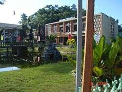
Balilihan municipal hall | ||
| ||
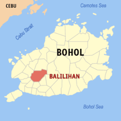 Map of Bohol with Balilihan highlighted | ||
.svg.png) Balilihan Location within the Philippines | ||
| Coordinates: 9°45′N 123°58′E / 9.75°N 123.97°ECoordinates: 9°45′N 123°58′E / 9.75°N 123.97°E | ||
| Country | Philippines | |
| Region | Central Visayas (Region VII) | |
| Province | Bohol | |
| District | 1st district of Bohol | |
| Founded | 29 September 1828 | |
| Barangay | 31 (see § Barangays) | |
| Government [1] | ||
| • Type | Sangguniang Bayan | |
| • Mayor | Ma Pureza Chatto (LP) | |
| • Vice mayor | Adonis Roy Olalo | |
| • Town Council |
Members
| |
| Area[2] | ||
| • Total | 127.27 km2 (49.14 sq mi) | |
| Elevation | 102 m (335 ft) | |
| Population (2015 census)[3] | ||
| • Total | 17,903 | |
| • Density | 140/km2 (360/sq mi) | |
| • Voter (2016)[4] | 11,556 | |
| Time zone | PST (UTC+8) | |
| ZIP code | 6342 | |
| IDD : area code | +63 (0)38 | |
| Income class | 4th class | |
| PSGC | 071206000 | |
| Website |
balilihan | |

Balilihan is a 4th municipal income class municipality in the province of Bohol, Philippines.[2] Balilihan is located 22 kilometres (14 mi) northeast of Tagbilaran through Cortes (via CPG North Avenue), or 20 kilometres (12 mi) northeast through Corella (via J.A. Clarin Street). It has the fourth largest land area of the province, with 150 square kilometres (58 sq mi) of land. According to the 2015 census, it has a population of 17,903.[3] In the 2016 election, it had 11,556 registered voters.[4]
History
The place is a panorama of verdant hills, rugged mountains and green fields. It is said to have been so named because of the grass "balili" which grew in abundance.
Before the beginning of the 19th century, Balilihan was a barrio of Baclayon and an old settlement where the families of Orig, Dangoy, Racho, Maniwang, Lacea and Pongase were the first inhabitants. When the Dagohoy revolt was suppressed by the Spaniards, the authorities established a garrison in Datag (one of its barrios) to discourage and stamp out further uprisings on the part of the natives. When Balilihan was separated from its mother town on 29 September 1828, the Spanish government formally established a settlement or pueblo in the sitio "Bay sa Iring" (named so for the network of caves where cats hide) which was about 2 kilometres (1.2 mi) from the Spanish garrison.
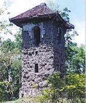
Later, due to the scarcity of water, the seat of government was transferred to its present site which is amply supplied with water from various springs. The elevated land also made a good viewing point to keep watch over all nearby towns. Thus the construction of a Spanish belfry similar to the watch towers of the shores atop the hill. This tower is made of adobe stones gathered from the rock deposits of Baclayon. It was erected in the year 1835. It was inaugurated in 1846 gobernadorcillo. In 1888, Friar Benito Grayoa, who at that time exercised control over local governments, ordered the transfer of the municipio to Cabad, a barrio 4 kilometres (2.5 mi) west of the poblacion. The padre's plan met vigorous opposition from the people and through the able leadership of Capitan Bartolome Racho, they filed the protest before the Spanish Military Governor Linares who disapproved the proposal causing Friar Grayoa's ire who then plotted for the consequent punishment of the captain by dragging him with the friar's horse through the streets causing his death in jail. Fearing reprisals from the clergy, some of the people migrated to Surigao, Leyte and Misamis. Not long afterwards, Friar Grayoa was transferred to Siquijor.
The Spanish era flourished with the construction of Spanish church at the foot of the Spanish watchtower where a large patio became the hall for social affairs and the friar's convent a school for the cartilla, with the municipio across. With the guidance of the local appointed leaders under the control of the Spanish friar, the town slowly progressed peacefully until the outbreak of the revolution in 1898.
On 12 November 1900, American soldiers were known to be coming from Antequera. All officials of the town led by Capitan Antonio Racho came out to meet the soldiers with a brass band, but when the Americans arrived, they gathered all the officials in the municipal hall building and placed them under guard, for the Americans had heard that the town officials had been supporting the insurgents. The supplications of spokesman Segundo Racho not to burn the town was of no avail and the sounds of the welcoming brass band turned into volleys of gunshots. The officials were ordered to move towards Sevilla while the civilians ran for safety to the outskirts of the town. The town was razed to the ground. The Americans burned the church, the convent, the municipal building, the school building for boys and girls as well as private houses. The only structure that was spared was the belfry on the top of the hill.
In 1904, there was a move to fuse Balilihan with Antequera in order to meet the requirements of a municipality under the American regime. The people objected to the plan, so the following year the Philippine Commission finally ruled in its Act. No. 350 abolishing the municipality of Catigbi‑an and instead annexing it to Balilihan as one of its barrios.
During World War II, the town residents went into hiding in their mountain hideouts for fear of the Japanese. Balilihan was a haven of refugees from other places who lived a life of privation in the mountains. Many innocent civilians were either tortured or put into death by the enemies on mere suspicions of guerilla activities. Ex-mayor Patricio Ibarra was put up by the people as war time mayor to defend them from their enemies.
The Japanese atrocities gave rise to the organizations of the guerrillas into full combat force under the supreme command of Mayor Ismael Ingeniero. The people helped the guerilla movement by feeding the troops in the front lines as well as those in the headquarters in Behind the Clouds, in Maitum which was the famous concentration camp of the war. Enemy collaborators were tried here and those found guilty of high crimes were liquidated. Those with slight offenses were imprisoned for the duration of the war. Another concentration camp was at Hanopol where prisoners were kept.
In 1948, Balilihan suffered a great loss of territory when the biggest barrio (Catigbi‑an) was given its town charter in spite of the strong representation against the move by town mayor Balbino Chatto and Gerardo Racho who personally went to Malacañang to see President Elpidio Quirino. Catigbian was the given away to be on its own.
Barangays
Balilihan comprises 31 barangays:
| PSGC | Name | Population | ±% p.a. | |
|---|---|---|---|---|
| (2015)[3] | (2010)[5] | |||
| 071206001 | Baucan Norte | 666 | 688 | −0.62% |
| 071206002 | Baucan Sur | 799 | 852 | −1.22% |
| 071206003 | Boctol | 1,322 | 1,094 | 3.67% |
| 071206004 | Boyog Norte | 227 | 212 | 1.31% |
| 071206005 | Boyog Proper | 281 | 199 | 6.79% |
| 071206006 | Boyog Sur | 348 | 329 | 1.07% |
| 071206007 | Cabad | 677 | 570 | 3.33% |
| 071206008 | Candasig | 609 | 591 | 0.57% |
| 071206009 | Cantalid | 400 | 387 | 0.63% |
| 071206010 | Cantomimbo | 539 | 537 | 0.07% |
| 071206011 | Cogon | 774 | 835 | −1.43% |
| 071206012 | Datag Norte | 604 | 540 | 2.16% |
| 071206013 | Datag Sur | 498 | 414 | 3.58% |
| 071206014 | Del Carmen Este (Pob.) | 669 | 672 | −0.09% |
| 071206015 | Del Carmen Norte (Pob.) | 746 | 720 | 0.68% |
| 071206017 | Del Carmen Sur (Pob.) | 615 | 600 | 0.47% |
| 071206016 | Del Carmen Weste (Pob.) | 827 | 865 | −0.85% |
| 071206018 | Del Rosario | 230 | 260 | −2.31% |
| 071206019 | Dorol | 746 | 751 | −0.13% |
| 071206020 | Haguilanan Grande | 686 | 836 | −3.70% |
| 071206021 | Hanopol Este | 345 | 337 | 0.45% |
| 071206022 | Hanopol Norte | 384 | 349 | 1.84% |
| 071206023 | Hanopol Weste | 245 | 272 | −1.97% |
| 071206024 | Magsija | 611 | 477 | 4.83% |
| 071206025 | Maslog | 524 | 428 | 3.93% |
| 071206026 | Sagasa | 613 | 512 | 3.49% |
| 071206027 | Sal‑ing | 672 | 697 | −0.69% |
| 071206028 | San Isidro | 455 | 458 | −0.13% |
| 071206029 | San Roque | 546 | 519 | 0.97% |
| 071206030 | Santo Niño | 532 | 494 | 3.28% |
| 071206031 | Tagustusan | 713 | 652 | 1.72% |
| TOTAL | 17,903 | 17,147 | 0.82% | |
Demographics
| Population census of Balilihan | |||||||||||||||||||||||||
|---|---|---|---|---|---|---|---|---|---|---|---|---|---|---|---|---|---|---|---|---|---|---|---|---|---|
|
| ||||||||||||||||||||||||
| Source: National Statistics Office[3][5][6] | |||||||||||||||||||||||||
In the 2016 election, it had 11,556 registered voters, meaning that 65% of the population are aged 18 and over.[4]
- Number of households: 3,101[7]
- Average household size: 5.8
Education
-
- Balilihan Central Elementary School
- Baucan Elementary School
- Boctol Elementary School
- Boyog Primary School
- Cabad‑Candasig Elementary School
- Cantomimbo Primary School
- Cogon‑Tagustusan Elementary School
- Datag Elementary School
- Dorol Elementary School
- Haguilanan Grande Elementary School
- Hanopol Elementary School
- Magsija‑Maslog Elementary School
- Sagasa Elementary School
- Sal‑ing Elementary School
- San Isidro Primary School
- San Roque Elementary School
-
- Congressman Pablo Malasarte National High School (CPMNHS)
- Carmel Academy (CA)
- Hanopol High School (HHS)
- San Roque Integrated School (SRIS)
-
- Bohol Island State University (BISU) – Balilihan Campus
Town festival
The municipality of Balilihan holds its annual town fiesta every 16 July in honor of Our Lady of Mount Carmel, however, other barangays (Hanopol - comprising 10 barangays) celebrate their fiesta in honor of their patron Santo Niño de Cebú on the 16 January. Balilihan holds its fiestas every 6 months. Another celebration takes place during the last week of September, this gives way for making 29 September of every year as a non-working holiday in Balilihan.
Galleries
-

Abatan River
-
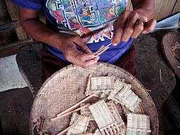
Making of baskets
-
_(14802959169).jpg)
Ceiling paintings of Balilihan Roman Catholic Church
-
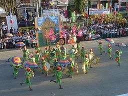
Festival in Balilihan, held every last week of September

References
- ↑ "Municipality". Quezon City, Philippines: Department of the Interior and Local Government. Retrieved 31 May 2013.
- 1 2 "Municipal: Balilihan, Bohol". PSA. Philippines: National Statistical Coordination Board. Retrieved 8 January 2016.
- 1 2 3 4 "Region VII (CENTRAL VISAYAS)". Census of Population (2015): Total Population by Province, City, Municipality and Barangay (Report). PSA. Retrieved 20 June 2016.
- 1 2 3 "2016 National and Local Elections Statistics". Commission on Elections. 2016.
- 1 2 "Region VII (CENTRAL VISAYAS)". Census of Population and Housing (2010): Total Population by Province, City, Municipality and Barangay (Report). NSO. Retrieved 29 June 2016.
- ↑ "Region VII (CENTRAL VISAYAS)". Census of Population (1995, 2000 and 2007): Total Population by Province, City and Municipality (Report). NSO. Archived from the original on 24 June 2011.
- ↑ "Municipality of Balilihan". Province of Bohol. Retrieved 2012-09-10.
External links
| Wikimedia Commons has media related to Balilihan. |
- Municipality of Balilihan
- Tirol, Jes. of Balilihan town The Bohol Chronicle
- Tirol, Jes. The Creation of the Municipality of Eva, Bohol (Janopol) The Bohol Chronicle
- Balilihan
 |
Catigbian | Batuan | | |
| Antequera | |
Bilar Sevilla | ||
| ||||
| | ||||
| Cortes | Corella | Sikatuna |