Trinidad, Bohol
| Trinidad | ||
|---|---|---|
| Municipality | ||
|
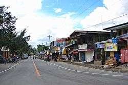
Poblacion, Trinidad highway | ||
| ||
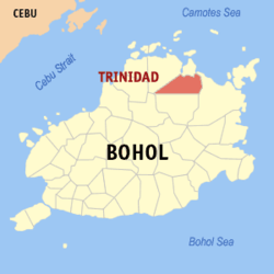 Map of Bohol with Trinidad highlighted | ||
.svg.png) Trinidad Location with the Philippines | ||
| Coordinates: 10°03′N 124°21′E / 10.05°N 124.35°ECoordinates: 10°03′N 124°21′E / 10.05°N 124.35°E | ||
| Country | Philippines | |
| Region | Central Visayas (Region VII) | |
| Province | Bohol | |
| District | 2nd district of Bohol | |
| Founded | 1947 | |
| Barangay | 20 (see § Barangays) | |
| Government [1] | ||
| • Type | Sangguniang Bayan | |
| • Mayor | Judith Cajes (LP) | |
| • Vice mayor | Manuel Garcia | |
| • Town Council |
Members
| |
| • Representative | Erico Aristotle Aumentado | |
| Area[2] | ||
| • Total | 195.3 km2 (75.4 sq mi) | |
| Population (2015 census)[3] | ||
| • Total | 31,956 | |
| • Density | 160/km2 (420/sq mi) | |
| • Voter (2016)[4] | 19,017 | |
| Time zone | PST (UTC+8) | |
| ZIP code | 6324 | |
| IDD : area code | +63 (0)38 | |
| Income class | 3rd class | |
| PSGC | 071244000 | |
| Website |
www | |
Trinidad is a 3rd municipal income class municipality in the province of Bohol, Philippines.[2] According to the 2015 census, it has a population of 31,956.[3] In the 2016 election, it had 19,017 registered voters.[4] The town was named after Trinidad Roxas, the wife of President Manuel Roxas, and the town is also known for Kawasan Falls and Batungay cave.
Barangays
Trinidad comprises 20 barangays:
| PSGC | Barangay | Population | ±% p.a. | Area[2] | PD 2015 | ||||
|---|---|---|---|---|---|---|---|---|---|
| 2015[3] | 2010[5] | ha | acre | /km2 | /sq mi | ||||
| 071244001 | Banlasan | 3.7% | 1,193 | 1,073 | +2.04% | 986 | 2,437 | 120 | 310 |
| 071244002 | Bongbong | 3.7% | 1,171 | 1,148 | +0.38% | 543 | 1,342 | 220 | 560 |
| 071244003 | Catoogan | 3.0% | 967 | 826 | +3.05% | 326 | 806 | 300 | 770 |
| 071244004 | Guinobatan | 6.4% | 2,038 | 2,011 | +0.25% | 560 | 1,384 | 360 | 940 |
| 071244005 | Hinlayagan Ilaud | 3.5% | 1,134 | 1,095 | +0.67% | 307 | 759 | 370 | 960 |
| 071244006 | Hinlayagan Ilaya | 6.8% | 2,175 | 1,825 | +3.40% | 441 | 1,090 | 490 | 1,300 |
| 071244007 | Kauswagan | 7.5% | 2,401 | 2,213 | +1.56% | 3,095 | 7,648 | 78 | 200 |
| 071244008 | Kinan‑oan | 4.6% | 1,462 | 1,311 | +2.10% | 446 | 1,102 | 330 | 850 |
| 071244009 | La Union | 6.2% | 1,995 | 1,747 | +2.56% | 708 | 1,750 | 280 | 730 |
| 071244010 | La Victoria | 5.0% | 1,611 | 1,518 | +1.14% | 559 | 1,381 | 290 | 750 |
| 071244012 | Mabuhay Cabiguhan | 3.8% | 1,211 | 1,133 | +1.28% | 303 | 749 | 400 | 1,000 |
| 071244013 | Mahagbu | 3.6% | 1,161 | 1,048 | +1.97% | 547 | 1,352 | 210 | 550 |
| 071244014 | Manuel A. Roxas | 3.6% | 1,138 | 1,017 | +2.16% | 624 | 1,542 | 180 | 470 |
| 071244015 | Poblacion | 11.2% | 3,576 | 2,936 | +3.83% | 762 | 1,883 | 470 | 1,200 |
| 071244016 | San Isidro | 1.6% | 501 | 629 | −4.24% | 615 | 1,520 | 81 | 210 |
| 071244017 | San Vicente | 6.1% | 1,958 | 1,799 | +1.63% | 2,294 | 5,669 | 85 | 220 |
| 071244018 | Santo Tomas | 3.4% | 1,100 | 1,013 | +1.58% | 650 | 1,606 | 170 | 440 |
| 071244019 | Soom | 6.2% | 1,991 | 1,716 | +2.87% | 411 | 1,016 | 480 | 1,300 |
| 071244020 | Tagum Norte | 5.1% | 1,614 | 1,358 | +3.34% | 462 | 1,142 | 350 | 900 |
| 071244021 | Tagum Sur | 5.0% | 1,599 | 1,412 | +2.40% | 570 | 1,409 | 280 | 730 |
| Total | 31,956 | 28,828 | +1.98% | ||||||
Demographics
| Population census of Trinidad | |||||||||||||||||||||||||
|---|---|---|---|---|---|---|---|---|---|---|---|---|---|---|---|---|---|---|---|---|---|---|---|---|---|
|
| ||||||||||||||||||||||||
| Source: Philippine Statistics Office[3][5][6] | |||||||||||||||||||||||||
In the 2016 election, it had 19,017 registered voters, meaning that 60% of the population are aged 18 and over.[4]
Gallery
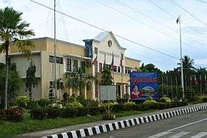 Town hall
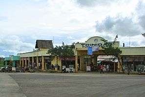 Public market
References
- ↑ "Municipality". Quezon City, Philippines: Department of the Interior and Local Government. Retrieved 31 May 2013.
- 1 2 3 "Municipal: Trinidad, Bohol". PSGC Interactive. Quezon City, Philippines: Philippine Statistics Authority. Retrieved 8 January 2016.
- 1 2 3 4 "Region VII (CENTRAL VISAYAS)". Census of Population (2015): Total Population by Province, City, Municipality and Barangay (Report). PSA. Retrieved 20 June 2016.
- 1 2 3 "2016 National and Local Elections Statistics". Commission on Elections. 2016.
- 1 2 "Region VII (CENTRAL VISAYAS)". Census of Population and Housing (2010): Total Population by Province, City, Municipality and Barangay (Report). NSO. Retrieved 29 June 2016.
- ↑ "Region VII (CENTRAL VISAYAS)". Census of Population (1995, 2000 and 2007): Total Population by Province, City and Municipality (Report). NSO. Archived from the original on 24 June 2011.
External links
 |
Bien Unido | | ||
| Talibon | |
Ubay | ||
| ||||
| | ||||
| San Miguel |
This article is issued from Wikipedia - version of the 8/7/2016. The text is available under the Creative Commons Attribution/Share Alike but additional terms may apply for the media files.