Calape, Bohol
| Calape | |
|---|---|
| Municipality | |
|
Center of Calape | |
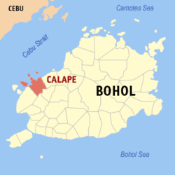 Map of Bohol with Calape highlighted | |
.svg.png) Calape Location within the Philippines | |
| Coordinates: 9°53′N 123°53′E / 9.88°N 123.88°ECoordinates: 9°53′N 123°53′E / 9.88°N 123.88°E | |
| Country | Philippines |
| Region | Central Visayas (Region VII) |
| Province | Bohol |
| District | 1st district of Bohol |
| Founded | 1802 |
| Barangay | 33 (see § Barangays) |
| Government [1] | |
| • Type | Sangguniang Bayan |
| • Mayor | Nelson Yu (LP) |
| • Vice mayor | Sulpicio Yu |
| • Town Council |
Members
|
| • Representative | Rene Relampagos |
| Area[2] | |
| • Total | 75.36 km2 (29.10 sq mi) |
| Elevation | 150 m (490 ft) |
| Population (2015 census)[3] | |
| • Total | 30,863 |
| • Density | 410/km2 (1,100/sq mi) |
| • Voter (2016)[4] | 20,449 |
| Time zone | PST (UTC+8) |
| ZIP code | 6328 |
| IDD : area code | +63 (0)38 |
| Income class | 3rd class |
| PSGC | 071210000 |
Calape is a 3rd municipal income class municipality in the province of Bohol, Philippines,[2] 41 kilometres (25 mi) north of Tagbilaran. According to the 2015 census, it has a population of 30,863.[3] In the 2016 election, it had 20,449 registered voters.[4] The first settlers of Calape were said to be migrants from Cebu, and from other municipalities of Bohol.
Its name is derived from cape, referring to either a species of rattan or to the local varietal of coffee, Kape Barako, both of which still grow abundantly there to this day.
History
By the time Spaniards arrived, there was already a native settlement in Calape. In 1802, the Spanish governor of Cebu established it as an independent municipality.
In 1957, Abucayan Norte was created from the sitios of Cabulihan and Cabinong, and Abucayan Sur from the sitios of Rama and Bino. The sitios of Binogawan, Masonoy, Bentig, Cahayag, and Lawis were also constituted into barrios.
Geography
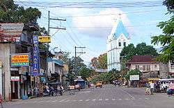
The town center faces the Cebu Strait on the western side of Bohol Island, about 41 kilometres (25 mi) from Tagbilaran. The jurisdiction of Calape includes the islands of Pangangan (eight barangays) and Mantatao, as well as two uninhabited islets, Poom Island and Basihan Island.
There are four rivers that flow through the territory: Tultugan and Liboron Rivers that drain into Calape Bay, and Calunasan and Abucayan Norte Rivers that drain into Tipcan Bay.
Most of the coastal area is a fairly level plain that gradually rises into rolling hills of coralline limestone. The highest point in Calape is Mount Candungao in the eastern portion of the town, with an elevation of 150 metres (500 ft) above sea level.[5]
Barangays
Calape comprises 33 barangays, of which 18 are coastal.
| PSGC | Barangay | Population | ±% p.a. | ||
|---|---|---|---|---|---|
| 2015[3] | 2010[6] | ||||
| 071210001 | Abucayan Norte | 4.5% | 1,402 | 1,326 | +1.07% |
| 071210002 | Abucayan Sur | 3.0% | 912 | 786 | +2.87% |
| 071210003 | Banlasan | 2.4% | 736 | 755 | −0.48% |
| 071210004 | Bentig | 6.3% | 1,949 | 1,797 | +1.56% |
| 071210005 | Binogawan | 1.4% | 428 | 466 | −1.61% |
| 071210006 | Bonbon | 4.2% | 1,296 | 1,222 | +1.13% |
| 071210007 | Cabayugan | 3.0% | 920 | 880 | +0.85% |
| 071210008 | Cabudburan | 1.6% | 507 | 548 | −1.47% |
| 071210009 | Calunasan | 2.3% | 718 | 798 | −1.99% |
| 071210010 | Camias | 1.5% | 468 | 505 | −1.44% |
| 071210011 | Canguha | 1.0% | 300 | 283 | +1.12% |
| 071210012 | Catmonan | 4.4% | 1,354 | 1,221 | +1.99% |
| 071210013 | Desamparados | 2.5% | 786 | 880 | −2.13% |
| 071210014 | Kahayag | 1.7% | 530 | 512 | +0.66% |
| 071210015 | Kinabag‑an | 2.1% | 639 | 511 | +4.35% |
| 071210016 | Labuon | 1.8% | 542 | 562 | −0.69% |
| 071210017 | Lawis | 2.1% | 635 | 617 | +0.55% |
| 071210018 | Liboron | 4.7% | 1,453 | 1,434 | +0.25% |
| 071210019 | Lo‑oc | 1.5% | 458 | 506 | −1.88% |
| 071210020 | Lomboy | 1.6% | 488 | 490 | −0.08% |
| 071210021 | Lucob | 4.6% | 1,431 | 1,330 | +1.40% |
| 071210022 | Madangog | 2.3% | 724 | 622 | +2.93% |
| 071210023 | Magtongtong | 2.1% | 639 | 404 | +9.12% |
| 071210024 | Mandaug | 4.4% | 1,358 | 1,451 | −1.25% |
| 071210025 | Mantatao | 2.8% | 849 | 967 | −2.45% |
| 071210027 | Sampoangon | 1.3% | 407 | 373 | +1.67% |
| 071210028 | San Isidro | 7.1% | 2,195 | 2,412 | −1.78% |
| 071210029 | Santa Cruz (Pob.) | 8.4% | 2,590 | 2,401 | +1.45% |
| 071210030 | Sohoton | 1.6% | 491 | 664 | −5.59% |
| 071210031 | Talisay | 1.5% | 470 | 415 | +2.40% |
| 071210032 | Tinibgan | 2.2% | 685 | 733 | −1.28% |
| 071210033 | Tultugan | 2.9% | 900 | 830 | +1.55% |
| 071210034 | Ulbujan | 5.2% | 1,603 | 1,445 | +2.00% |
| Total | 30,863 | 30,146 | +0.45% | ||
Demographics
| Population census of Calape | |||||||||||||||||||||||||
|---|---|---|---|---|---|---|---|---|---|---|---|---|---|---|---|---|---|---|---|---|---|---|---|---|---|
|
| ||||||||||||||||||||||||
| Source: Philippine Statistics Office[3][6][7] | |||||||||||||||||||||||||
In the 2016 election, it had 20,449 registered voters, meaning that 66% of the population are aged 18 and over.[4]
Religion
92% of Calape's population is Roman Catholic. The remaining 8% is divided among other religious groups.
Gallery
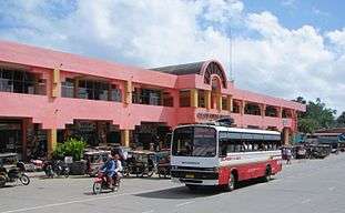 Public market
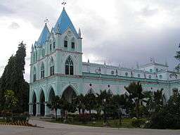 Catholic Church
Notable residents
- Yoyoy Villame, a novelty singer.
References
- ↑ "Municipality". Quezon City, Philippines: Department of the Interior and Local Government. Retrieved 31 May 2013.
- 1 2 "Municipal: Calape, Bohol". PSA. Philippines: National Statistical Coordination Board. Retrieved 8 January 2016.
- 1 2 3 4 "Region VII (CENTRAL VISAYAS)". Census of Population (2015): Total Population by Province, City, Municipality and Barangay (Report). PSA. Retrieved 20 June 2016.
- 1 2 3 "2016 National and Local Elections Statistics". Commission on Elections. 2016.
- ↑ "Topography". Municipality of Calape. Retrieved 3 October 2012.
- 1 2 "Region VII (CENTRAL VISAYAS)". Census of Population and Housing (2010): Total Population by Province, City, Municipality and Barangay (Report). NSO. Retrieved 29 June 2016.
- ↑ "Region VII (CENTRAL VISAYAS)". Census of Population (1995, 2000 and 2007): Total Population by Province, City and Municipality (Report). NSO. Archived from the original on 24 June 2011.
External links
| Wikimedia Commons has media related to Calape. |
 |
Cebu Strait | Tubigon | | |
| Cebu Strait | |
San Isidro | ||
| ||||
| | ||||
| Loon | Antequera |