Annapolis Park Historic District
|
Annapolis Park Historic District | |
|
Looking east on Hanover | |
  | |
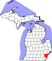
| Location | Julius, Matthew, Hanover, Farnum, Alan, and Paul, Westland, Michigan |
|---|---|
| Coordinates | 42°16′14″N 83°19′59″W / 42.27056°N 83.33306°WCoordinates: 42°16′14″N 83°19′59″W / 42.27056°N 83.33306°W |
| Area | 71 acres (29 ha) |
| Built | 1953 |
| Architectural style | Modern Movement |
| NRHP Reference # | 06000405[1] |
| Added to NRHP | May 18, 2006 |
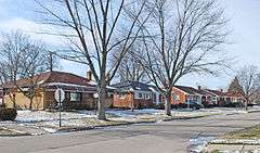
The Annapolis Park Historic District is a historic district located along Julius, Matthew, Hanover, Farnum, Alan, and Paul Streets in Westland, Michigan, covering 71 acres (290,000 m2) and 351 buildings.[1] It was listed on the National Register of Historic Places in 2006.[1]
History


During World War II, the African-American population in Detroit ballooned to 300,000 residents.[2] However, blacks were restricted in where they could live due to housing covenants, overpriced rent, and other forms of discrimination.[2] To alleviate the shortage of housing space, Julius and William Schwartz platted the Annapolis Park suburb in Westland in 1953 specifically for African-Americans.[2] The brothers also established the Franklin Mortgage Company to make loans to residents.[2] By 1957, all 354 lots in the subdivision had sold.[2]
References
- 1 2 3 National Park Service (2009-03-13). "National Register Information System". National Register of Historic Places. National Park Service.
- 1 2 3 4 5 State of Michigan historic marker from the state of Michigan, retrieved 1/18/10
| Lists by county |
|   |
|---|---|---|
| Other lists |
| |