Wyaralong Dam
| Wyaralong Dam | |
|---|---|
|
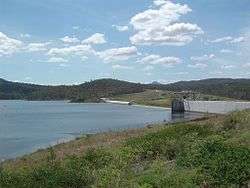
The dam wall, from the viewing platform. | |
 Location of the Wyaralong Dam in Queensland | |
| Country | Australia |
| Location | South East Queensland |
| Coordinates | 27°54′33″S 152°52′52″E / 27.90917°S 152.88111°ECoordinates: 27°54′33″S 152°52′52″E / 27.90917°S 152.88111°E |
| Purpose | Potable water supply[1][2] |
| Status | Operational |
| Construction began | 2010 |
| Opening date | 2011 |
| Construction cost | A$380 million |
| Operator(s) | SEQ Water |
| Dam and spillways | |
| Type of dam | Gravity dam |
| Impounds | Teviot Brook |
| Height | 48 m (157 ft)[1] |
| Length | 490 m (1,610 ft)[1][2] |
| Dam volume | 218,300×103 m3 (7,710×106 cu ft)[1] |
| Spillway type | Uncontrolled |
| Reservoir | |
| Total capacity | 102,883 ML (22,631×106 imp gal; 27,179×106 US gal)[2] |
| Catchment area | 546 km2 (211 sq mi)[1][2] |
| Surface area | 1,230 ha (3,000 acres)[1][2] |
|
Website www | |
The Wyaralong Dam is a mass concrete gravity dam with an un-gated spillway across the Teviot Brook that is located in the South East region of Queensland, Australia. The main purpose of the dam is for supply of potable water for the Scenic Rim region.[1] The impounded reservoir is also called Wyaralong Dam. The dam was initiated by the Queensland Government in 2006 as a result of a prolonged drought which saw the catchment areas of South East Queensland's dams receive record low rain.
Location and features
The dam is located approximately 14 kilometres (8.7 mi) north-west of Beaudesert.
The Wyaralong Dam was completed prior to the 2010–2011 Queensland floods. On January 11, during the flood period, the Mayors of both Logan City and Scenic Rim said they believed that Logan had been spared a great deal of flood damage because of the dam.[3]
The concrete dam structure is 48 metres (157 ft) high and 490 metres (1,610 ft) long. The dam wall is constructed from a medium cementitious mix roller compacted concrete.[4] The foundation is a sub horizontal dipping blocky sandstone. The dam is built with a 130-metre (430 ft) wide uncontrolled central primary spillway and an uncontrolled left bank secondary spillway which commences discharging at the 1:100 year flood level. The dam cross section is rather squat in order to provide sufficient resistance against potential sliding along foundation bedding planes. The 218,300-thousand-cubic-metre (7,710×106 cu ft) dam wall holds back the 103,000-megalitre (23×109 imp gal; 27×109 US gal) reservoir when at full capacity. From a catchment area of 546 square kilometres (211 sq mi) that includes much of the western portion of the McPherson Range, the dam creates an unnamed reservoir with a surface area of 1,230 hectares (3,000 acres). Teviot Brook and the surrounding land is a recognised Aboriginal Pathway with significant cultural heritage values.
The dam is managed by SEQ Water as part of a water security project in the South East Queensland region, known as the South East Queensland Water Grid.[5] The outlet is on the right bank and is capable of abstracting water from any level of the reservoir by the use of baulks. The outlet includes an innovative and operationally complex bidirectional fish lift, which uses a single hopper to transport fish in both upstream and downstream directions.
Conception
The site was identified in a 1990 study, Water Supply Sources in South-East Queensland, as a future source of water supply for the South East Queensland region. In this report, the site of Wyaralong Dam was ranked 13th out of 15 studied possible dam locations in the region. A location on the Albert River at Glendower, also near Beaudesert, was the preferred location and the government subsequently bought back all the land required for the Glendower Dam. A new dam was not expected to be required until 2060 or later and Glendower Dam remained the preferred dam site, the land already fully government owned.
In October 2005, in advance of the state election, the Queensland government announced Wyaralong Dam as the new preferred option, even after recent studies into possible dam locations found a location upstream on the Logan River to be a more reliable option. After a series of studies, a Senate Inquiry and much contested information, Federal Environment Minister Peter Garrett granted approval for the dam in November 2008.[6]
The dam is a storage and regulation facility. It does not discharge directly into the piped reticulation network, but rather discharges back into the natural drainage network of creeks and brooks. Water released from the dam flows downstream along Teviot Brook to Cedar Grove Weir, where it is diverted for treatment and use in the piped network.
Construction

The construction was tendered under an alliance contract. In this type of contract risks and rewards are shared by all the proponents including designers constructors and the owner. Queensland Dam Consortium won the tender for the dam's construction, and the Alliance was formed from their members which included Macmahon Construction as the lead contractor, Hydro Tasmania, Snowy Mountains Engineering Corporation, Paul Rizzo and Associates (USA), ASI Contractors (USA) and Queensland Water Infrastructure the special purpose vehicle created by the Queensland Government owner to deliver the project.[4] The Alliance contract for dam construction was for a little over A$100 million. However it was widely reported that the building costs for the dam would total A$333 million.[7] The latter figure includes the cost of the Bromelton Offpeak Storage Project, Cedar Grove Weir and the reconstruction of a length of the Boonah to Beaudesert Road.
Work on access roads began in early 2009 and construction of the dam wall began in early 2010.[7] The diversion channel was plugged on 17 December 2010, allowing the dam to begin to fill.[8] The dam site was opened to the public on 3 June 2011.[9] The 12 kilometres (7.5 mi) of new road between Boonah and Beaudesert were constructed under a separate contract by Fulton Hogan.[4]
The dam cost A$380 million to construct, including purchasing farmland flooded by the dam reservoir.[10]
Treatment
By late 2012 the dam still had not been connected to the SEQ Water Grid because it contains water so mineralised it is cheaper to produce desalinated water than to treat it.[10] The Wyaralong water treatment plant is expected to cost A$235 million to construct.[11] Funding for the plant is planned for the 2014/15 financial year.
January 2011 floods
As a result of rainfall during the 2010–2011 Queensland floods the dam filled to 100% capacity, just 25 days after the wall was plugged to hold water, but before its completion.[8] By 10 January during the flood period, the dam held 83,133 megalitres (18,287×106 imp gal; 21,961×106 US gal), 80.7 per cent of its 103,000 megalitres (23×109 imp gal; 27×109 US gal) capacity. Parts of the dam were still under construction, but its wall was plugged to hold water on 17 December 2010.[12] On 11 January the dam filled and began to overtop at 9:27am, Following the overtopping, in the first 24 hours over 17,300 megalitres (3,800×106 imp gal; 4,600×106 US gal) of water flowed over the primary spillway and entered the Logan River at Cedar Grove.[8]
See also
References
- 1 2 3 4 5 6 7 "Register of Large Dams in Australia" (Excel (requires download)). Dams information. Australian National Committee on Large Dams. 2010. Retrieved 5 July 2014.
- 1 2 3 4 5 "Wyaralong Dam". Water supply: Dams and weirs. Seqwater. 2014. Retrieved 5 July 2014.
- ↑ "On the road in Logan today". Logan West Leader. 11 January 2011. Retrieved 13 January 2011.
- 1 2 3 "Wyaralong Dam contractors announced". Queensland Water Infrastructure Pty Ltd. Retrieved 22 October 2009.
- ↑ Hurst, Daniel (7 July 2009). "Water funds slash debt". The Bayside Bulletin. Retrieved 21 April 2008.
- ↑ "Wyaralong dam decision 'devastating' for residents". ABC News. Australia. 26 November 2008. Retrieved 22 October 2009.
- 1 2 "Wyaralong Dam to boost jobs, economy: Lucas". ABC News. Australia. 21 January 2009. Retrieved 2009-10-22.
- 1 2 3 "Wyaralong Dam". Seqwater. Retrieved 27 November 2012.
- ↑ Maeseele, Melanie (4 June 2011). "Summer rains fill up dam". The Queensland Times. Retrieved 27 November 2012.
- 1 2 Thomson, Tuck (16 October 2012). "Bligh government-built Wyaralong Dam an expensive 'mistake'". The Courier-Mail. Queensland. Retrieved 16 October 2012.
- ↑ Lion, Patrick (19 June 2011). "Water wasted as State Government decides against tapping into $350m dam". The Sunday Mail. Queensland. Retrieved 27 November 2012.
- ↑ "Wivenhoe Dam hits record high". The Queensland Times. 11 January 2011. Retrieved 13 January 2011.
External links
| Wikimedia Commons has media related to Wyaralong Dam. |
Water supply in Queensland, Australia | |||||||||||||||||||||
|---|---|---|---|---|---|---|---|---|---|---|---|---|---|---|---|---|---|---|---|---|---|
| |||||||||||||||||||||
| |||||||||||||||||||||