Southedge Dam
| Southedge Dam | |
|---|---|
|
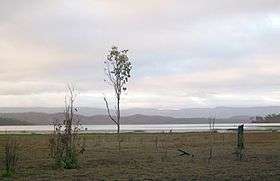
View of Lake Mitchell, created by Southedge Dam, from the Mulligan Highway, 2009. | |
 Location of the dam wall in Queensland | |
| Official name | Lake Mitchell Dam |
| Country | Australia |
| Location | Far North Queensland |
| Coordinates | 16°46′41″S 145°18′22″E / 16.77806°S 145.30611°ECoordinates: 16°46′41″S 145°18′22″E / 16.77806°S 145.30611°E |
| Purpose | Irrigation |
| Status | Operational |
| Construction began | 1986 |
| Opening date | 1987 |
| Owner(s) | Southedge Pastoral Pty Ltd |
| Dam and spillways | |
| Type of dam | Embankment dam |
| Impounds | Mitchell River |
| Height (foundation) | 16.5 metres (54 ft) |
| Length | 530 metres (1,740 ft) |
| Reservoir | |
| Creates | Lake Mitchell |
| Total capacity | 190,000 megalitres (42×109 imp gal; 50×109 US gal) |
| Active capacity | 129,000 megalitres (28×109 imp gal; 34×109 US gal) |
| Catchment area | 321 square kilometres (124 sq mi) |
| Surface area | 3,290 hectares (8,100 acres) |
The Southedge Dam, also known as the Lake Mitchell Dam,[1] is an earth filled embankment dam across the Mitchell River located in Far North Queensland, Australia. Opened in 1987 as an ornamental lake, the impoundment created by the dam is called Lake Mitchell and at full supply level has an active capacity of 129,000 megalitres (28×109 imp gal; 34×109 US gal).
Location and features
Commenced in 1986 and opened a year later, the Southedge Dam wall consists of an earth-fill embankment 530 metres (1,740 ft) in length and 16.5 metres (54 ft) high. The reservoir has a catchment area of 321 square kilometres (124 sq mi). The reservoir has a total capacity of 190,000 ML (42,000,000×103 imp gal; 50,000,000×103 US gal) of water; and covers an area of 3,290 ha (8,100 acres).[1][2] Southedge Dam has remained unused since it was opened in 1987;[3] constructed and owned by Southedge Pastoral Company.[4][5]
When the dam spills over it flows into the Mitchell River.
See also
References
- 1 2 "Register of Large Dams in Australia" (Excel (requires download)). Dams information. Australian National Committee on Large Dams. 2010. Retrieved 30 November 2015.
- ↑ MITCHELL RIVER (QLD)- Assessment
- ↑ Mitchell, draft water resource plan
- ↑ WATER REGULATION 2002 - SCHEDULE 12
- ↑ Queensland Environment Groups’ Submission
External links
Water supply in Queensland, Australia | |||||||||||||||||||||
|---|---|---|---|---|---|---|---|---|---|---|---|---|---|---|---|---|---|---|---|---|---|
| |||||||||||||||||||||
| |||||||||||||||||||||