Woodstock, New Brunswick
| Woodstock | ||
|---|---|---|
| Town | ||
|
On the Saint John River | ||
| ||
| Nickname(s): Service center of the valley | ||
| Motto: New Brunswick’s First Town | ||
 Location of Woodstock in New Brunswick | ||
| Coordinates: 46°09′42″N 67°35′11″W / 46.16176°N 67.58647°W | ||
| Country | Canada | |
| Province | New Brunswick | |
| County | Carleton County | |
| Parish | Woodstock Parish | |
| Incorporated | May 1, 1856 | |
| Government | ||
| • Type | Council–manager government | |
| • Mayor | Arthur L. Slipp | |
| • Councillors | Amy Anderson, Catherine L. Sutherland, Randy Leonard, Bill Hogan, Theresa E. Blackburn, Jeff G Bradbury | |
| • Chief Administrative Officer | Kenneth C. Harding | |
| Area | ||
| • Total | 13.41 km2 (5.18 sq mi) | |
| Elevation | 36 to 85 m (118 to 279 ft) | |
| Population (2011) | ||
| • Total | 5,254 | |
| • Density | 391.7/km2 (1,014/sq mi) | |
| • Change 2006-11 |
| |
| Time zone | AST (UTC-4) | |
| • Summer (DST) | ADT (UTC-3) | |
| Canadian Postal code | E7M | |
| Area code(s) | 506 | |
| Telephone Exchange(s) | 328, 325, 324, 612, 594 | |
| NTS Map | 021J04 | |
| GNBC Code | DAWNW | |
| Website | http://town.woodstock.nb.ca | |
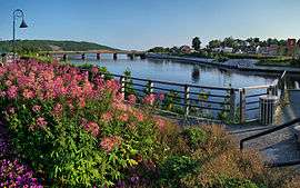
Woodstock is a town in Carleton County, New Brunswick, Canada. It is located on the west bank of the Saint John River at the mouth of the Meduxnekeag River, 92 km north-west of Fredericton and close to the Canada–United States border and Houlton, Maine. The town is the administrative headquarters of the Woodstock Maliseet First Nation band government.[1]
History
| Historical population | ||
|---|---|---|
| Year | Pop. | ±% p.a. |
| 1847 | 600 | — |
| 1857 | 1,581 | +10.17% |
| 1867 | 4,300 | +10.52% |
| 1881 | 3,000 | −2.54% |
| 1901 | 3,644 | +0.98% |
| 1911 | 3,856 | +0.57% |
| 1921 | 3,380 | −1.31% |
| 1931 | 3,259 | −0.36% |
| 1941 | 3,593 | +0.98% |
| 1951 | 3,996 | +1.07% |
| 1961 | 4,305 | +0.75% |
| 1971 | 4,846 | +1.19% |
| 1981 | 4,649 | −0.41% |
| 1986 | 4,549 | −0.43% |
| 1991 | 4,782 | +1.00% |
| 1996 | 5,092 | +1.26% |
| 1999 | 4,631 | −3.11% |
| 2001 | 5,231 | +6.28% |
| 2004 | 5,100 | −0.84% |
| 2006 | 5,113 | +0.13% |
| 2011 | 5,254 | +0.55% |
Woodstock was settled by Loyalists following the American War of Independence. It was named for Woodstock Parish, established in 1786, which in turn was named for William Cavendish-Bentinck, 3rd Duke of Portland and Viscount Woodstock, who was briefly British Prime Minister in 1783.
The upper limit of Loyalist grants on the river fell to members of Colonel De Lancey's Brigade who fought successfully in the Siege of Ninety-Six and at the Battle of Eutaw Springs.[2] They accepted the land and moved there early in the summer of 1784.[3] Three small settlements were formed in this new area named Woodstock and they were: the Upper Corner; the Creek Village; and Lower Woodstock.
When Carleton County first came into being in 1832, Upper Woodstock was made the shiretown due to the influence of Colonel Richard Ketchum who donated land for construction of public buildings. The Old Carleton County Court House is now an historic site, having been restored under the Carleton County Historical Society. However, after a bridge was built across the Meduxnekeag River, there was rapid growth of the Creek Village and this resulted in its being chosen as the Town of Woodstock.
Woodstock, incorporated in 1856, is the oldest incorporated town in New Brunswick. The first mayor was L.P. Fisher, who held office until his voluntary retirement some 24 years later. Being a great benefactor, he made provisions in his will for the building of several educational institutions, among them the first Agricultural and Vocational School in Canada, and the L. P. Fisher Public Library.
The headquarters for the New Brunswick Railway were here from 1870 until it ceased functioning.
Charles Connell (1810 – June 28, 1873) was a Canadian politician from Woodstock, now remembered mainly for placing his image on a 5-cent postage stamp. His house, known as the Charles Connell House is now a museum run by the Carleton County Historical Society.
Another important landmark of Woodstock from as early as the 40s and 50s was the Capital Theatre which was run by one-time Woodstock mayor Edgar Neal. It was located on Queen Street which is now known as Capital Square, home of a residence area for community college students. When the theatre was first opened, someone had to be paid to play the piano during the silent films. It was also used for boxing matches and magic shows among many other things.
The first dam at the mouth of the Meduxnekeag River was built in 1886, and activated on December 1, 1886. It provided electric power for the town; inviting the beginning of industrial activity that included tanneries, carriage factories, a wool mill, sawmills and gristmills, two foundries producing stoves; furnaces and agricultural machinery, etc. Others followed.
The last one, the Hayden[4] dam and its powerhouse[5] was destroyed by an unusually high spring freshet, exacerbating the spring flood of May 1, 1923, which also washed out the bridge that crossed the Meduxnekeag.[6]
Another unusually high spring freshet on April 1, 1987 resulted in major damage to the Canadian Pacific Railway's trackage and a railway bridge in Upper Woodstock lost two spans. This hastened CPR's decision to abandon rail service to the area. Today the former railway right-of-way is one of Woodstock's walking trails.
On October 22, 1966, the New Brunswick Youth Orchestra made its debut in Woodstock.
Presently, Woodstock is the shopping centre for the surrounding area, being the closest town to the border. Downtown Woodstock remains the heart of the town. It has a number of new boutiques such as Miss Fancy Pants and Made You Blush. Uptown consists of several fast food chains, Carleton Mall and Atlantic Cinemas.
A campus of the New Brunswick Community College is located here. Woodstock is also home to the Woodstock Airport, a small public airport located in Grafton. This small community overlooks the Saint John River, allowing people to get a view of Woodstock.
In 1995 the Town of Woodstock opened the Carleton Civic Centre. The multipurpose complexes houses 25 metre indoor pool, an 846-seat arena, a fitness centre, and community meeting rooms. The Woodstock Slammers of the Maritime Junior Hockey League play at the Civic Centre.
Woodstock is also the home to the annual Old Home Week fair, usually held at the fair grounds at Connell Park. During this time Woodstock traditionally hosts the Miss New Brunswick Pageant.[7]
In 2009, the River Valley Arts Alliance (RiVA) began hosting the Dooryard Arts Festival in downtown Woodstock. It has now been held in August of every summer since and is currently planning the 8th Annual Dooryard Arts Festival for 2016.[8]
Disasters
A "hurricane" swept through on July 27, 1836.[9] An Orange riot occurred in the town on July 12, 1847.[10][11] The riot occurred at the corner of Victoria and Boyne streets, adjacent to the site of the now vanished Orange Hall[12] (built 1848).[13] Nearly 300 Orangemen and 300 Irish Catholics rioted there, with ten deaths. Only the Irish were blamed.[14]
Cholera struck in 1854. 15 died.[15]
A portion of Woodstock was burned on April 16, 1860.[16][17]
In 1861, the newly built railway between St. Andrews and Woodstock was seized by several hundred navvies, angry at not being paid.[18] A peaceful settlement was later made personally by Arthur Hamilton-Gordon.[19]
Six acres of the town were consumed by fire on May 17, 1877. 85 buildings, mostly businesses were destroyed at a loss of $275,000.[20] In November 1881, fires started by Irish agitators[21] burned 80 buildings.[22]
A fire swept the town on January 30, 1911. A sawmill and factory were destroyed, but rebuilt soon after.[23]
Government
Mayor and council
Woodstock elects a Mayor and a Town Council every four years. All councilors are elected at-large. The last election was May 2012.[24]
Chief administrative officer
The administration of Woodstock is overseen by the Chief Administrative Officer (CAO). The CAO and the Administration Department is responsible for the town financial matters, record keeping, implementation of policies and directives, and providing support to all other departments and the Town Council. The position of Chief Administrative Officer was formerly known as Town Manager. Woodstock was the first town in New Brunswick to have a Manager-Council form of government.[25]
| Town Managers/Chief Administrative Officers[26] | ||
|---|---|---|
| # | Manager/CAO | Term |
| 1st | R. Fraser Armstrong | 1919–1923 |
| 2nd | Michael J. Rutledge | 1923–1927 |
| 3rd | Blake Allen | 1927–1929 |
| 4th | Gordon MacPhail | 1929–1931 |
| 5th | A. Gordon Bailey | 1931–1941 |
| 6th | George B. Kilpatrick | 1941–1944 |
| 7th | Carl W. Groman | 1944–1946 |
| 8th | Douglas MacBride | 1946–1947 |
| 9th | Avard J. Bird | 1947–1947 |
| 10th | Oliver H. Manuel | 1947–1949 |
| 11th | Wesley H. Steeves | 1949–1952 |
| 12th | James R. Calkin | 1952–1959 |
| 13th | George B. Kilpatrick | 1959–1966 |
| 14th | Thomas L. Everett | 1967–1983 |
| 15th | Edward L. Dickinson | 1983–1996 |
| 16th | Kenneth C. Harding | 1996–present |
Other departments
The Woodstock's other town departments are, Business Development, Development & Inspectional Services, Fire, Police, Public Works, Recreation, and Tourism.[25]
Climate
Woodstock experiences a humid continental climate. The highest temperature ever recorded in Woodstock was 39.4 °C (103 °F) on 18 August 1935. Woodstock, along with Rexton and Nepisiguit Falls share the record for New Brunswick's highest recorded temperature.
| Climate data for Woodstock, 1981–2010 normals, extremes 1886–present | |||||||||||||
|---|---|---|---|---|---|---|---|---|---|---|---|---|---|
| Month | Jan | Feb | Mar | Apr | May | Jun | Jul | Aug | Sep | Oct | Nov | Dec | Year |
| Record high °C (°F) | 13.5 (56.3) |
16.5 (61.7) |
26.0 (78.8) |
31.5 (88.7) |
35.6 (96.1) |
35.6 (96.1) |
36.7 (98.1) |
39.4 (102.9) |
34.4 (93.9) |
30.0 (86) |
22.8 (73) |
16.1 (61) |
39.4 (102.9) |
| Average high °C (°F) | −6.0 (21.2) |
−3.3 (26.1) |
2.2 (36) |
9.4 (48.9) |
17.6 (63.7) |
22.9 (73.2) |
25.3 (77.5) |
24.7 (76.5) |
19.4 (66.9) |
12.0 (53.6) |
4.4 (39.9) |
−2.3 (27.9) |
10.5 (50.9) |
| Daily mean °C (°F) | −11.5 (11.3) |
−9.5 (14.9) |
−3.4 (25.9) |
3.7 (38.7) |
10.9 (51.6) |
16.3 (61.3) |
19.0 (66.2) |
18.4 (65.1) |
13.2 (55.8) |
6.6 (43.9) |
0.3 (32.5) |
−7.0 (19.4) |
4.8 (40.6) |
| Average low °C (°F) | −17.0 (1.4) |
−15.6 (3.9) |
−8.9 (16) |
−2.0 (28.4) |
4.1 (39.4) |
9.6 (49.3) |
12.6 (54.7) |
12.0 (53.6) |
6.9 (44.4) |
1.1 (34) |
−3.9 (25) |
−11.7 (10.9) |
−1.1 (30) |
| Record low °C (°F) | −43.5 (−46.3) |
−43.9 (−47) |
−37.2 (−35) |
−23.3 (−9.9) |
−9.4 (15.1) |
−6.7 (19.9) |
−1.1 (30) |
−1.0 (30.2) |
−6.7 (19.9) |
−13.3 (8.1) |
−25.0 (−13) |
−40.6 (−41.1) |
−43.9 (−47) |
| Average precipitation mm (inches) | 104.0 (4.094) |
71.6 (2.819) |
91.2 (3.591) |
80.4 (3.165) |
94.2 (3.709) |
91.0 (3.583) |
100.2 (3.945) |
100.6 (3.961) |
95.7 (3.768) |
95.3 (3.752) |
103.2 (4.063) |
103.2 (4.063) |
1,130.6 (44.512) |
| Source: Environment Canada[27][28] | |||||||||||||
Transportation
Woodstock is located on New Brunswick Route 2, an alignment of the Trans-Canada Highway. The shorter New Brunswick Route 95 extends westward from Woodstock to the Houlton/Woodstock Border Crossing, where it continues into the United States as Interstate 95.
Media
Woodstock has a small set of media, consisting of a radio station and a newspaper, The Bugle-Observer. The community is also served by WAGM-TV in Presque Isle, Maine in addition to regional Global, CTV and CBC Television newsrooms in Fredericton and Saint John.
Radio
Woodstock's current radio station is 104.1 FM CJCJ, branded as CJ 104. In May 2009, the station name was changed to CJ 104, to reflect a shift in the type of music being played by the station, from light rock to contemporary.[29]
Woodstock has had at least 22 newspapers operating at one time or another. The first was the Carleton Sentinel, beginning in July 1848 and ending in March 1943, merging with The Press to form the Sentinel Press. The Sentinel Press ended publication on June 1971.
The Bugle-Observer is the town's biweekly newspaper, which is owned by the Irving family's Brunswick News. The paper went by the name of The Bugle for several years until it was sold to Brunswick News in 2003. Shortly thereafter, Brunswick News also bought the weekly paper in neighbouring town of Hartland, The Observer. The staff of the two papers were combined into one office in Woodstock, at first producing two separate issues. Later, the papers were combined under one name, Bugle-Observer, which publishes twice weekly on Tuesday and Friday.
An independent paper, the Carleton Free Press was launched on October 31, 2007. The paper was published by the former publisher of the Bugle-Observer, Kenneth Langdon, until its cessation on October 28, 2008.
Notable people
- Edwin Tappan Adney, artist, writer, and photographer. Credited with saving the art of birch bark canoe construction.
- William Teel Baird, a pharmacist and militia officer
- Bartholomew Crannell Beardsley, lawyer, judge and political figure in Upper Canada and New Brunswick.
- Dalton Camp, Canadian journalist, politician, political strategist and commentator. Supporter of the Progressive Conservative Party of Canada and a central figure in Red Toryism.
- Frank Broadstreet Carvell, Canadian lawyer, businessman, and politician.
- Charles Connell, Canadian politician, now remembered mainly for placing his image on a 5-cent postage stamp.
- Harold Culbert, Member of the Canadian House of Commons from 1993 to 1997.
- H.V. Dalling (1854-1931), watchmaker, jeweller, inventor. Made and installed a homemade telephone whose wires ran between his home and shop. Bell Telephone later opened a small exchange in his store.[30]
- Lewis P. Fisher, Woodstock's first mayor, served from the town's incorporation in 1856 until 1880
- James Kidd Flemming, Premier of New Brunswick from 1911 to 1914.
- George Gee, The first person to be hanged in Woodstock
- Myles Goodwyn, Guitarist, lead vocalist, main songwriter and founding member of the veteran Canadian hard rock band April Wine. Goodwyn was born in Woodstock, but did not live there. This was confirmed by Goodwyn himself during April Wine's 2005 concert at the Carleton Civic Center.
- Richard Hatfield, New Brunswick politician and long time Premier of the province (1970–1987).
- Marcel Mason, Canadian Blogger and political activist
- Lindsay G. Merrithew is Canadian entrepreneur, executive producer, producer, and actor.
- Charlie Russell, former country music DJ for CJCJ. Member of the Canadian Country Music Hall of Fame
- Minnie Bell Sharp, Conducted the Woodstock School of Music for several years and ran for Federal office as a Conservative in 1919 and 1925. Successfully sued the Woodstock school board after her arrest for non-payment of taxes.
- A. Edison Stairs, Canadian businessman and politician.
- Sid Veysey, Retired professional ice hockey centre who played 1 game in the National Hockey League in 1977
- George Frederick Clarke, novelist, poet, historian, angler, amateur archaeologist, conservationist.
- Eastside #1 Alpha
Mining
The region has been the past center of iron working and mining.
Rock containing iron was discovered here in 1820,[31] and in 1826 there was a report of low-grade iron ore. In 1848 operations began on some iron-manganese deposits, continuing until 1884.
Zinc, copper,[32] and lead have also been mined here.
Surassite has been found in the nearby Strategic Manganese Mine, beginning in 1836.[33][34][35]
Obsidian and other volcanic debris have been found in the area.
References
- ↑ http://www.woodstockfirstnation.com/
- ↑ W. O. Raymond (January 1902). "Brave Soldier of the Revolution". In David Russell Jack. Acadiensis; a quarterly devoted to the interests of the maritime provinces of Canada. II. p. 241. Retrieved 2014-03-14.
- ↑ Wright, Esther Clark (February 1972). "The Process of Possession". The Loyalists of New Brunswick (2nd. ed.). Canada: Moncton Pub. Co. Ltd. pp. 180–181.
Block 8, Woodstock, 1st DeLancey's, grant to Robert Brown and 119 others, October 15, 1784
- ↑ "Causes of Flooding". The Flooding Problem in the Saint John River Basin. Inland Water Directorate. December 1973. p. 34.
- ↑ Campbell, John. "Power House and Dam". Retrieved 25 June 2012.
- ↑ Campbell, John. "1923 Flood". Retrieved 25 June 2012.
- ↑ "Miss New Brunswick - Our History". Retrieved 1 October 2010.
- ↑ "Dooryard Arts Festival".
- ↑ "Terrifick Hurricane at Woodstock". The Evening Post. New-York. 25 Aug 1836. p. 2 – via newspapers.com.
- ↑ Baird, William T. (1978). Seventy years of New Brunswick life: autobiographical sketches (Reprint ed.). St. Annes Point Press. pp. 156–162. ISBN 978-0-920762-00-4. Retrieved 28 March 2013.
- ↑ Bell, D. G. "The Battle of Woodstock". Carleton County Historical Society. Retrieved 3 November 2010.
- ↑ Campbell, John. "Orange Hall - Woodstock". Retrieved 25 June 2012.
- ↑ Connell, Allison (1988). A view of Woodstock : historic homes of the nineteenth century. Fredericton, N.B.: New Ireland Press. p. 19. ISBN 0920483194.
- ↑ "Orange Riot Site". Canada's Historic Places. Retrieved 25 June 2012.
- ↑ Seventy Years. pp.188-192
- ↑ Seventy Years. pp.195-199
- ↑ "Destructive Conflagration". Nashville Union and American. 19 Apr 1860.
- ↑ New Brunswick. House of Assembly (1863). Journals of the House of Assembly of the Province of New Brunswick. G.E. Fenety. pp. 114–116.
- ↑ Seventy Years. pp.217-218
- ↑ Seventy Years. pp.271-272
- ↑ "Fiendish Designs". Arizona Weekly Citizen. Tucson, Arizona. 11 Dec 1881. p. 2.
Two of his men burned Woodstock, New Brunswick recently.
- ↑ "The conflagration at Woodstock". The Record-Union. Sacramento, California. 12 Nov 1881. p. 8.
- ↑ Campbell, John. "Hayden's Saw Mill". Retrieved 25 June 2012.
- ↑ "Mayor & Council". Woodstock. Town of Woodstock. Retrieved January 24, 2015.
- 1 2 "Administration". Woodstock. Town of Woodstock. Retrieved January 24, 2015.
- ↑ "List of Past Town Managers" (PDF). Town of Woodstock. Retrieved 2015-01-24.
- ↑ "Woodstock". 1981–2010 Canadian Climate Normals. Environment Canada. Retrieved 29 May 2016.
- ↑ "March 2012". Canadian Climate Data. Environment Canada. Retrieved 29 May 2016.
- ↑ Dean, Katelin (May 1, 2009). "What's in a name". Bugle-Observer (Weekend). p. A3.
- ↑ Thompson, Colleen Whitney (1994). Roads to Remember: The Insider's Guide to New Brunswick. p. 58. ISBN 0-86492-160-8.
- ↑ Gesner, F.G.S., Provincial Geologist, Araham (1842). Report on the Geological Survey of the Province of New Brunswick, Issue 4. H. Chubb. p. 46.
- ↑ Atlantic Geoscience Society (2001). "From Rocks to Riches". The Last Billion Years. p. 155. ISBN 1-55109-351-0.
- ↑ "MOODY HILL & IRON ORE HILL (Also known as JACKSONVILLE FE-MN, WOODSTOCK FE-MN)". New Brunswick Mineral Occurrence Database. Retrieved 25 June 2012.
- ↑ "Strategic Manganese Mine, Woodstock, New Brunswick, Canada". Mindat.org. 2013-12-27. Retrieved 2014-03-14.
- ↑ Sursassite Image Mineral News
External links
| Wikimedia Commons has media related to Woodstock, New Brunswick. |
| Wikivoyage has a travel guide for Woodstock (New Brunswick). |
Coordinates: 46°09′08″N 67°35′54″W / 46.152222°N 67.598333°W
| Subdivisions | |
|---|---|
| Cities | |
| Towns | |
| |