Saint John River (Bay of Fundy)

| Designations | |
|---|---|
| Official name | Wolastoq National Historic Site of Canada |
| Designated | 2011 |
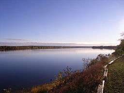
The Saint John River (French: Fleuve Saint-Jean) is a river, approximately 418 miles (673 km) long, located principally in the Canadian province of New Brunswick but also in and arising from the province of Quebec and the U.S. state of Maine. It forms part of the Canada–United States border in two different places along its length. The river drains an area of approximately 55,000 square kilometres (21,000 sq mi), of which slightly more than half is located in New Brunswick. Along that portion of the Atlantic shoreline of North America that lies between the St. Lawrence River and the Mississippi River, the Saint John River is the second longest waterway; only the Susquehanna is longer. It has been nicknamed the "Rhine of North America".[1] The river is regulated by hydro power dams located at Mactaquac, Beechwood, and Grand Falls, New Brunswick.
Description
The Baker Branch of the Saint John River rises in the Saint John Ponds of Somerset County in northwestern Maine. The Southwest Branch of the Saint John River originates in Little Saint John Lake on the Maine–Quebec border near Saint-Zacharie, Quebec, and forms the international boundary between Maine and Quebec as it flows northeasterly to join the Baker Branch in northern Somerset County. The Northwest Branch of the Saint John River rises from Lac Frontière in Montmagny Regional County Municipality near the southeastern Quebec border and flows southerly through Maine to a confluence with the Daaquam River and then easterly to a confluence with the Southwest Branch.
The branches combine to form the main river flowing northeastward through western Aroostook County (46°33′47″N 69°53′06″W / 46.5630°N 69.8850°W). The Lacroix road built in 1923 from Lac-Frontière crosses the river at Ninemile Bridge.[2] Near Seven Islands the river was crossed by an 18th century trail from the St. Lawrence River.[3] There is an Abenaki burial site containing a large number of graves where the Big Black River joins the Saint John in township 18, range 13, WELS. Local legend maintains the confluence is haunted by the spirits of Abenaki killed by an epidemic of European disease.[4]
Near Allagash, the Saint John is joined by the Allagash River. The whole portion of the Saint John River that lies entirely in Maine is essentially a wilderness waterway, although many smoothly weathered granite boulders within the channel were broken by blasting during the early 20th century log driving.[5] Below St. Francis, the Saint John begins to form part of the international boundary between Maine and New Brunswick.
Continuing its northeasterly course, the river passes Fort Kent, Maine, and then flows between Edmundston, New Brunswick, and Madawaska, Maine, where it turns southeast, passing between Van Buren, Maine, and Saint-Léonard, New Brunswick. Near Grand Falls, New Brunswick, the river enters entirely into New Brunswick, and changes direction to flow due south through the fertile Upper Saint John River Valley, framed by the rising hills of the Appalachian range in Victoria and Carleton counties. At Perth-Andover, the river is joined by the Aroostook and the Tobique rivers. At Hartland, it is crossed by the longest covered bridge in the world.
Further south at Woodstock, the river leaves the Upper Valley and turns east, heading away from the border region. It is joined by Nackawic Stream at Nackawic and passes small communities such as Bear Island. The Maliseet capital of Meductic was located along the Saint John River in the 17th and into the mid-18th century. This site was flooded in 1965 after completion of the Mactaquac Dam with the waterline level 133 feet (41 m) above sea level. The river continues eastward until it reaches New Brunswick's capital city Fredericton (where it becomes navigable, at an elevation of 6 feet (1.8 m) above sea level) and then the military town of Oromocto. Turning south from Oromocto, the river is joined by the short Jemseg River which empties New Brunswick's largest lake, Grand Lake. This part of the river valley becomes broad and shallow. The river is dotted by many low islands used for pastureland during dry periods in the summer and fall.
South of the Jemseg, the Saint John River is surrounded by the low hills of the St. Croix Highlands. It is joined by several lateral bays, including Belleisle Bay, the Nerepis River and the Kennebecasis River. The Saint John River finally discharges into the Bay of Fundy at the industrial city of Saint John. Near the river's mouth is the site of the Reversing Falls, caused by the high tides of the Bay of Fundy. These tides are the highest in the world and cause the river to reverse its flow twice a day in a narrow gorge in the city's centre.
The Saint John River has a maximum depth of 50 metres above the Mactaquac Dam.
History
Members of the Wolastoqiyuk Nation, known also as the Maliseet, whose lands and culture have been and still are centered on the Saint John River, have historically called the river Wolastoq, translating to "good and beautiful river". This early historic connection between the Maliseet people and the Saint John River is embodied in their native name itself, and as the Wolastoqiyuk name translates to mean the people of the Wolastoq, the very cultural identity of the Maliseet was deeply tied to the river. The Saint John River, with its islands, shorelines and tributaries, was the homeland of the Maliseet, and these places were marked with the graves of their ancestors, village campsites, and symbolic place-names and origin stories which were a testament to the long historic presence of the Maliseet people on the river.[6]
In 1604, parts of the lower river were explored by Samuel de Champlain and Sieur de Monts. Champlain named the river after John the Baptist because he reached the river's mouth on the saint's feast day of June 24. The Maliseet, from their village of Meductic on the Saint John River, served as allies of the French and conducted numerous raids against the New Englanders below the Kennebec River, Maine (i.e., the Acadia/New England border) throughout the French and Indian Wars as well as Father Rale's War.
French colonists developed the lower river valley as an important part of their colony of Acadia. Acadian settlements along the lower river during the 17th and 18th centuries included Fort La Tour (Saint John) and Pointe Sainte-Anne (Fredericton).
In 1758, during the French and Indian War, the North American front of the Seven Years' War, Colonel Robert Monckton began the St. John River Campaign. The British burned the Acadian villages along the river, forcing the inhabitants to flee, or taking them prisoner prior to deportation. The entire area fell under English control after their capture of Fort Sainte-Anne in Fredericton at the end of the St. John River Campaign (1759).
The Royal Proclamation of 1763 had a direct impact on the Maliseet Nation along the Saint John River, or as it was first named by the indigenous peoples of the area, the Wəlastəkok. The proclamation stated that no British settlers could purchase lands belonging to the indigenous inhabitants. Land purchases could only be negotiated by the Crown. All the lands belonging to the "Indians", communities as well as hunting and fishing grounds, were to be left for their continued use.[7] The land on the Wəlastəkok was desirable to settlers, as it was a waterway connection between the Atlantic coast and Quebec, farming land, fishing grounds, and had mineral wealth. The proclamation did not stop settlers from obtaining the land they wanted. Organizations such as the St. John River Society were formed shortly after the proclamation was issued, in order to determine how to get around the new laws. Soon after, new survey maps were drafted, with First Nations deliberately left off, and many indigenous place names changed or Anglicized. By doing this, the land appeared empty, and now fell under a category of adopted Roman law called Terra Nullius. This law allows any unoccupied land to be taken over by the finder.
In her chapter from Shaping an Agenda for Atlantic Canada, Andrea Bear Nicholas writes, "With a map that represented the land as empty and two proclamations inviting English settlers to 'vacated' lands, Nova Scotia [included New Brunswick during this time] authorities began actively recruiting speculators and settlers to the region."[8]
In 1784, many Loyalist refugees from the American Revolutionary War were resettled in Saint John, Fredericton, and along the river at other settlements such as Queensbury and Woodstock. The arrival of the Loyalists was the catalyst for organization of the new British colony of New Brunswick. Saint John was named the capital, but it was moved to Fredericton some 60 miles (97 km) up river during the War of 1812 in fear of capture by the Americans. During that time a Martello tower was constructed to protect the Saint John harbour. British settlement of the fertile Upper River Valley did not take place until the early-to-mid-19th century. An immigrant Danish community (New Denmark) was established in the late 19th century.
In 1785, Acadians returning from the deportation settled in the Upper Saint John River valley, near what is now Edmundston. Somewhat later in the mid-19th century, francophone Quebecers also settled the Madwaska region, travelling southwards along traditional portage routes from the Saint Lawrence River valley. They joined the Acadians. The Madawaska section of the river valley is still strongly francophone in the 21st century.
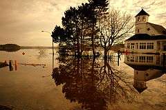
The river was an important trade route for French, English and First Nations traders throughout the 17th and 18th centuries. The tremendous flow rate of the river and its tributaries during the spring freshet aided the development of the timber industry in western New Brunswick, and the river became a conduit for log drives to sawmills and pulp mills in the south. The spring freshet can prove disastrous to property owners along portions of the river, particularly when ice jams cause extensive flooding during the spring break-up.

With the development of lumbering and agricultural resources, the upper river valley area, by the 1820s and 1830s, became increasingly economically important. Both American and British citizens settled the area and, since the international boundary in this area was poorly defined, conflict between the British colony of New Brunswick and the state of Maine inevitably erupted. The Aroostook War developed when the respective state and colonial militias were called out. At the height of the tensions brought on by the Aroostook War, the positioning of the Maine militia on the Aroostook and Fish rivers while British troops were north and east of the Saint John River would eventually become the officially established boundary line between Maine and New Brunswick. During the boundary negotiations led by Lord Ashburton between 1839 and 1842, Maine wanted to retain the Aroostook River valley as well as the right to freely navigate the Saint John River. American surveyors had actually ventured up through a lot of the poorly drained land north of the Saint John River to realize its value was of little significance. A positive compromise that came out of the Aroostook war was the third article of the Webster–Ashburton Treaty which stated that navigation on the Saint John River would be completely free and open to both New Brunswick and Maine.[9] The border was ultimately defined by the Webster-Ashburton Treaty of 1842, but land disputes carried on for many years among settlers and lumbermen with legitimate claims.[10]
The Saint John River in the 19th century was integral to the development of western New Brunswick. As it had for thousands of years, it served as the principal transportation artery to the region, particularly prior to the era of rail transport, when paddle wheelers plied its waterways.

New Brunswick industrialist Alexander Gibson commissioned a survey in 1866 for a railway line extending from his mill facilities in South Devon at the river junction with the Nashwaak River opposite Fredericton, north to Edmundston to service timber lands which he leased from the Crown. A charter for the railway was received from the provincial government in 1870, and the New Brunswick Land and Railway Company (NBR) was formed. Part of the charter provided for additional timber land based upon construction performance, thereby making Gibson one of the largest landowners in the province. Andrew George Blair, while Minister of Railways and Canals in the government of Wilfrid Laurier, was instrumental in forging the railway line further onwards to its junction with the rest of Canada in Quebec City. The entire NBR was sold in 1941 by Canadian Pacific Railways, which operated the railway in the first half of the 20th century, to forestry operator J. D. Irving Limited.
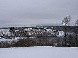
During the 1950s and 1960s, the river was developed as a major source of hydroelectric power with the construction of the Beechwood Dam in 1955 and the Mactaquac Dam in 1965. Large reservoirs were created behind the dams. These massive projects followed the construction of a smaller dam at Grand Falls in 1925, where the river descends in a steep cataract. Construction of the latter two dams has caused a severe decline in migrating Atlantic salmon, and resource authorities have developed fish ladders and other measures to try to revive the migration. In addition, much fertile farmland was flooded to create the headponds.
In recent years, the river has been a destination for recreational boating and ecotourism. The rich soil of the Upper Saint John River Valley in Carleton and Victoria counties in New Brunswick and Aroostook County in Maine continues to be cultivated for potatoes.
In 2011, the river was designated a National Historic Site of Canada and is noted for its importance to the Wolastoq First Nation.[11]
Water flow
- See also 2008 Saint John River Flood
The United States Geological Survey maintains three gauges on the river to measure water flow on the portion running through its territory. The furthest upstream gauge is located in an unnamed township at (46°42′00″N 69°42′59″W / 46.70000°N 69.71639°W) where the rivershed is 1,341 square miles (3,470 km2). A second gauge is located at Dickey, Maine (47°06′44″N 69°05′25″W / 47.11222°N 69.09028°W) where the rivershed is 2,680 square miles (6,900 km2). The third gauge is maintained in cooperation with the Water Survey of Canada (WSC) on the Canadian bank in Clair, New Brunswick, at (47°15′35″N 68°35′45″W / 47.25972°N 68.59583°W) where the rivershed is 5,665 square miles (14,670 km2).
WSC also maintains its own gauges on the river in New Brunswick at Edmundston, Grand Falls, Fredericton, Maugerville, Upper Gagetown, Gagetown, Oak Point, and Saint John.
At the most upstream gauge the riverflow has ranged from 44,400 cubic feet per second (1,260 m3/s) to 59 cubic feet per second (1.7 m3/s). At the Dickey gauge flow has ranged from 91,700 cubic feet per second (2,600 m3/s) to 129 cubic feet per second (3.7 m3/s). At the Clair gauge flow has ranged from 151,000 cubic feet per second (4,300 m3/s) to 510 cubic feet per second (14 m3/s). Water flow is highest during the spring freshet and lowest in the fall. In early spring, upper sections of the river can experience ice jams causing flooding,[12] while in the lower sections in the broader floodplain, flooding may occur during late spring from the sheer volume of water which must make its way through the narrow gorge at the Reversing Falls.
Literary works relating to the Saint John River
The Building of the Bridge: An Idyl of the River Saint John written by Barry Straton is a poem that reflects on the bridge that was being built over the Saint John River in Fredericton in the 1880s.[13] The 19-page poem was published in 1887. The Fredericton Bridge was a wooden pedestrian and wagon bridge commissioned in 1884 in order to connect the growing the communities along the river. The region was flourishing in part due to the railway system. The bridge was completed the next year and officially opened on November 27, 1885.[14]
The last stanza on page 10 references the fears people had of the choice of building materials, wood rather than steel or concrete. Because of the regional climate, flooding can be extensive and bring large chunks of ice, washed away trees, and other debris at high speed. People were unsure if the wooden bridge would withstand the temperament of the river.
"Called from the eloquent solitudes
of fair New Brunswick's wealthy woods,
Tough birch, outlasting years of years,
shall form foundations for the piers.
Jointed and bolted, and hemmed around
By ponderous piles which pierce the ground,
And filled with anchoring tons of rocks,
Deep in the stream the stout cribs lie,
And stem the tide which rushes by
And bravely bear the ice-floe's shocks.
O, builders! lay them true and strong;
For if the humbler work go wrong
The finer parts ye rear in vain:
Even so the social life of a man,
Which national strength may ne'er attain..."[1]
- ^ Straton, Barry. "The Building of the Bridge: An Idyl of the River Saint John". Archive. J&A McMillan, Printers and Publishers. Retrieved May 7, 2015.
Despite fears of the chosen building materials the bridge lasted 10 years, only failing after catching on fire and burning down.[15][16]
"The keel of Lake Dickey", written by John McPhee and published in The New Yorker in 1976, chronicles a canoe trip from the headwaters of the Saint John River to the confluence with the Allagash. In the essay, McPhee documents the wild state of the river at a time when a hydroelectric dam project at Dickey was gaining political traction.[17]
See also
- List of crossings of the Saint John River
- List of longest rivers of Canada
- List of rivers of Maine
- List of bodies of water of New Brunswick
- Port of Saint John
Notes
- ↑ "Geography". About New Brunswick. Government of New Brunswick. Retrieved 25 June 2015.
- ↑ Jackson (2007) p. 123
- ↑ Jackson (2007) p. 120
- ↑ Jackson (2007) p. 139
- ↑ Jackson (2007) p. 194
- ↑ Nicholas, Andrea Bear. "Settler Imperialism and the Dispossession of the Maliseet, 1758-1765" in Reid, John G., and Donald J. Savoie eds. Shaping an Agenda for Atlantic Canada. Winnipeg: Fernwood Pub, 2011. p. 23, 27
- ↑ https://primarydocuments.ca/documents/RoyalProc11763Oct7
- ↑ Nicholas, Andrea Bear. "Settler Imperialism and the Dispossesstion of the Maliseet, 1758-1765" in Reid, John G., and Donald J. Savoie eds. Shaping an Agenda for Atlantic Canada. Winnipeg: Fernwood Pub, 2011
- ↑ Judd, Richard William, and Patricia A. Judd. "Forging an International Economy." In Aroostook: A Century of Logging in Northern Maine. Orono: University of Maine Press, 1988. p. 33, 37, 38
- ↑ Judd (1988)p.32
- ↑ Wolastoq. Directory of Federal Heritage Designations. Parks Canada. Retrieved 4 May 2012.
- ↑ G.J. Stewart; J.P. Nielsen; J.M. Caldwell; A.R. Cloutier (2002). "Water Resources Data - Maine, Water Year 2001" (PDF). Water Resources Data - Maine, Water Year 2001. Archived from the original (PDF) on 2005-11-18. Retrieved 2006-05-07.
- ↑ Straton, Barry. "The Building of the Bridge: An Idyl of the River Saint John". Archive. J&A McMillan, Printers and Publishers. Retrieved May 7, 2015.
- ↑ http://www.canadianpoetry.ca/architexts/building_bridge/introduction.htm
- ↑ http://www.canadianpoetry.ca/architexts/building_bridge/introduction.htm
- ↑ Image of Fredericton Bridge c. 1902
- ↑ McPhee, John (3 May 1976). "The keel of Lake Dickey". The New Yorker: 43. Retrieved 6 March 2016.
References
- Jackson, Annette (2007). My Life in the Maine Woods. Islandport Press. ISBN 0-9763231-9-2.
- Judd, Richard (1988). "Forging an International Economy" in Aroostook, a century of logging in Northern Maine. University of Maine Press.
External links
![]() Media related to Saint John River at Wikimedia Commons
Media related to Saint John River at Wikimedia Commons
- Voici the Valley Audio Story and Guide information and excerpts
- St. John River watershed map and information
- Oceanographic study of the salt and fresh water exchange in the lower St. John River
- Real-time river flow at the upstream most gage, Dickey, Maine, or St. Clair, New Brunswick
- The Upper St. John River Valley history and genealogy
- Live WebCam courtesy of the Maine Department of Transportation
- Saint John River, Geographical Names Board of Canada
| Provinces | |
|---|---|
| Territories | |
| Other countries | |
| |