Wonalancet, New Hampshire
| Wonalancet, New Hampshire | |
|---|---|
| Unincorporated community | |
|
Wonalancet Union Chapel in the center of the village | |
 Wonalancet  Wonalancet | |
| Coordinates: 43°54′26″N 71°21′2″W / 43.90722°N 71.35056°WCoordinates: 43°54′26″N 71°21′2″W / 43.90722°N 71.35056°W | |
| Country | United States |
| State | New Hampshire |
| County | Carroll |
| Town | Tamworth |
| Elevation | 1,099 ft (335 m) |
| Time zone | Eastern (EST) (UTC-5) |
| • Summer (DST) | EDT (UTC-4) |
| ZIP code | 03897 |
| Area code(s) | 603 |
| GNIS feature ID | 872963[1] |
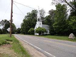
Wonalancet is an unincorporated community in the northwestern corner of the town of Tamworth in Carroll County, New Hampshire, United States.[1] Many popular hiking trails into the Sandwich Range of the White Mountains have trailheads in the area, particularly in the locale known as Ferncroft, up a short spur road from Wonalancet.
The village is named for the Pennacook Indian leader Wonalancet.
Wonalancet has a separate ZIP code (03897) from the rest of Tamworth.
References
External links
Municipalities and communities of Carroll County, New Hampshire, United States | ||
|---|---|---|
| Towns | 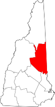 | |
| Township | ||
| CDPs | ||
| Other villages | ||
This article is issued from Wikipedia - version of the 7/10/2016. The text is available under the Creative Commons Attribution/Share Alike but additional terms may apply for the media files.