South Tamworth, New Hampshire
| South Tamworth, New Hampshire | |
|---|---|
| Unincorporated community | |
|
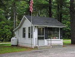
South Tamworth Post Office | |
 South Tamworth  South Tamworth | |
| Coordinates: 43°49′29″N 71°18′11″W / 43.82472°N 71.30306°WCoordinates: 43°49′29″N 71°18′11″W / 43.82472°N 71.30306°W | |
| Country | United States |
| State | New Hampshire |
| County | Carroll |
| Town | Tamworth |
| Elevation | 577 ft (176 m) |
| Time zone | Eastern (EST) (UTC-5) |
| • Summer (DST) | EDT (UTC-4) |
| ZIP code | 03883 |
| Area code(s) | 603 |
| GNIS feature ID | 870062[1] |
South Tamworth is an unincorporated community in the town of Tamworth in Carroll County, New Hampshire, United States. It is located along New Hampshire Route 25, next to the Bearcamp River. Route 25 continues east past the village of Whittier to West Ossipee, where it intersects New Hampshire Route 16. To the west, Route 25 leads to Moultonborough, Center Harbor, and Meredith.
South Tamworth has a separate ZIP code (03883) from the rest of Tamworth.
References
Municipalities and communities of Carroll County, New Hampshire, United States | ||
|---|---|---|
| Towns | 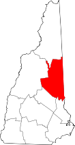 | |
| Township | ||
| CDPs | ||
| Other villages | ||
This article is issued from Wikipedia - version of the 7/10/2016. The text is available under the Creative Commons Attribution/Share Alike but additional terms may apply for the media files.