Wollomombi Falls
| Wollomombi Falls | |
|---|---|
|
Wollomombi Falls | |
 | |
| Location | New England, New South Wales, Australia |
| Coordinates | 30°31′55″S 152°02′05″E / 30.53194°S 152.03472°ECoordinates: 30°31′55″S 152°02′05″E / 30.53194°S 152.03472°E[1][2] |
| Type | Plunge |
| Elevation | 907 metres (2,976 ft) AHD |
| Total height | 150–230 metres (490–750 ft) |
| Number of drops | 1 |
| Longest drop | 100 metres (330 ft)[3] |
| Watercourse | Wollomombi River |
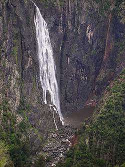
The Wollomombi Falls (/hwɒlˈlɑːˈmʌmˈbiː/, from an Aboriginal word), is a plunge waterfall on the Wollomombi River located in the New England region of New South Wales, Australia.
Location and features
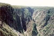

Located in the Oxley Wild Rivers National Park approximately 40 kilometres (25 mi) due east of Armidale and 1.45 kilometres (0.90 mi) off the Waterfall Way,[4] the Wollomombi Falls are situated atop the Wollomombi Gorge near the confluence of the Wollomombi River with the Chandler River. The Chandler Falls are located on the Chandler River, adjacent to the Wollomombi Falls. The falls descend from an elevation of 907 metres (2,976 ft) above sea level in one drop of 100 metres (330 ft),[3] with a total descend that ranges in height between 150–230 metres (490–750 ft) depending on the flow of the river.[4]
At one time they were believed to be the tallest in Australia. However, recent geographical revisions place them at second or third tallest, depending on the source, after the Tin Mine Falls in the Snowy Mountains and the Wallaman Falls, near Ingham, Queensland.[3]
Hiking tracks and campground
Several camp grounds and walking tracks are located adjacent to the Wollomombi Falls and provide access to see the waterfall. Constructed by the National Parks and Wildlife Service are the Wollomombi Gorge and Falls Picnic Area, the 4-kilometre (2.5 mi) long, three-hour return Wollomombi Walking Track, the 2.5-kilometre (1.6 mi) long, 90 minute return Chandler Walking Track, and the Wollomombi Campground.[5] The Chandler Walk route passes Checks Lookout before reaching the Chandler Lookout and then winding down to the bottom of the gorge downstream from the falls. Checks Lookout is about a third of the way along this walk with a view back along the gorge to the falls. At the end of the track 400 metres (1,300 ft) below the top of the gorge, hikers can explore the river or swim in one of the many deeper pools. The Wollomombi Walk takes the walker upstream past a lookout platform and across the Wollomombi River on a long steel bridge. The river can be explored at this point. The track continues to another lookout platform which looks down on the falls from the opposite side of the gorge. A further extension of the track ends at a platform with spectacular views into the Chandler River gorge which joins the Wollomombi Gorge.[6]
Edgars Lookout provides an easily accessible view of the gorge on the western side of the falls lookouts.
Facilities include drinking water, pit toilets, shelter shed, fireplace and bush camping sites are available for overnight stays. An information display is also provided.
See also
References
- ↑ "Wollomombi Falls". Geographical Names Register (GNR) of NSW. Geographical Names Board of New South Wales. Retrieved 12 May 2014.
- ↑ "Wollomombi Falls (NSW)". Gazetteer of Australia online. Geoscience Australia, Australian Government.
- 1 2 3 "Tallest waterfalls in Australia". Geoscience Australia (Press release). Government of Australia. 3 July 2002. Retrieved 14 May 2014.
- 1 2 "Map of Wollomombi Falls, NSW". Bonzle Digital Atlas of Australia. Retrieved 12 May 2014.
- ↑ "Wollomombi Gorge, Oxley Wild Rivers National Park". Waterfall Way parks: Visitor Guide (PDF). National Parks and Wildlife Service. April 2014. pp. 7–8. Retrieved 14 May 2014.
- ↑ "Wollomombi Falls". Short Walks. Chris Hann. 2008.
External links
- Northern Rivers Geology Blog - Wollomombi
- "Wollomombi Gorge and Falls picnic area". Parks: Oxley Wild Rivers National Park. National Parks and Wildlife Service.
- "Wollomombi Falls - Armidale". Destination NSW. Government of New South Wales.
- "Information about Wollomombi Falls". Your information guide to Northern NSW, Australia. November 1999.