West Union Covered Bridge (Indiana)
| West Union Covered Bridge | |
| National Register of Historic Places | |
 West Union Covered Bridge | |
| Official name: West Union Covered Bridge | |
| Named for: West Union, Indiana | |
| Country | |
|---|---|
| State | |
| County | Parke |
| Township | Reserve |
| Road | Tow Path Road (C.R. 525W) Road bypasses bridge, bridge closed to vehicular traffic. |
| Crosses | Sugar Creek, Parke County, Indiana |
| Coordinates | 39°51′17.75″N 87°20′8.75″W / 39.8549306°N 87.3357639°WCoordinates: 39°51′17.75″N 87°20′8.75″W / 39.8549306°N 87.3357639°W |
| Length | 337 ft (103 m) 310ft +10ft +17ft overhangs on each end |
| Width | 17 ft (5 m) [1] |
| Clearance | 14.5 ft (4 m) |
| Builder | Daniels, J.J. |
| Design | Double Burr Arch truss double span bridge |
| Material | Wood |
| Built | 1876 Original Cost $16,125 or $8,900 |
| - Repaired abutments | 1913 and 1931 |
| Owned and Maintained by | Parke County |
| WGCB Number | #14-61-27 [2] |
| Added to NRHP | Dec 22, 1978 |
| NRHP Ref# | 78000414 [3] |
| MPS | Parke County Covered Bridges TR |
 Location of the West Union Bridge in Indiana | |
 Location of Indiana in the United States | |
The West Union Covered Bridge is north-northeast of Montezuma, Indiana. The two-span Burr Arch Truss covered bridge structure was built by Joseph J. Daniels in 1876. It is notable for being the longest standing covered bridge in Parke County.[4][5]
It was added to the National Register of Historic Places in 1978.[3]
History
The West Union Covered Bridge is the third bridge to stand at this location. The Star Mill Covered Bridge was the first and then the Harrison Covered Bridge replaced it but was damaged in 1876 prompting the West Union Covered Bridge to be built. The bridge was finished in September 1876. The road was originally part of the "Indiana State Highway", established with Legislature in 1827, which connected Fort Wayne with Terre Haute. Along with the Armiesburg Covered Bridge it hosted stage coach traffic to Lafayette.
Not much is left of West Union today, only a handful of houses. Gone are the school, post office, and the railroad. The Wabash Erie Canal ran just west of town with a feeder canal running south of Sugar Creek and connecting to the west of the bridge. The Chicago & Eastern Illinois Railroad crossed Sugar Creek to the east of the bridge and past West Union on the west side. Little is left of evidence of the railroad or the canal today. Farmers reclaimed the land and farm most of it today.
Gallery
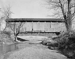
 View of Northwest portal.
 Detail of Southeast abutment with view of double Burr Arch rings bearing on abutment and lower truss details.
 Interior view of double Burr Arches, Kings Posts, and upper truss.
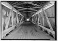 View looking Southeast of interior of bridge.
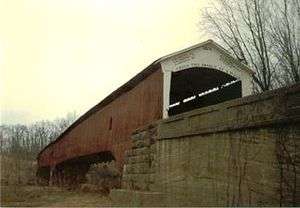
 View of Southeast portal. (Note new bridge to far left)
 View out of east window looking east.
 Detail of Southeast of abutment.
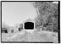 View of Southeast portal.
 View of center abutment from Southeast abutment.
 View of Southwest side of bridge from South.
- Detail of wall inscription showing 1914 date and names of county officials at time of building.
- View of wall, built in 1914 after flood damaged original walls, and Southeast portal.
See also
- List of Registered Historic Places in Indiana
- Parke County Covered Bridges
- Parke County Covered Bridge Festival
References
- ↑ "West Union Covered Bridge (#26).". Parke County Convention & Visitors Commission. Retrieved 16 January 2015.
- ↑ http://www.indianacrossings.org/bridgeLinks/14-61-27.html
- 1 2 National Park Service (2007-01-23). "National Register Information System". National Register of Historic Places. National Park Service.
- ↑ "West Union Covered Bridge". Parke County Incorporated / Parke County Convention and Visitors Commission. Retrieved 2012-10-18.
- ↑ "Indiana State Historic Architectural and Archaeological Research Database (SHAARD)" (Searchable database). Department of Natural Resources, Division of Historic Preservation and Archaeology. Retrieved 2016-06-01. Note: This includes Charles Felkner (December 1977). "National Register of Historic Places Inventory Nomination Form: Parke County Covered Bridge Historic District" (PDF). Retrieved 2016-06-01. and Site map.
External links
|
|
- Historic American Engineering Record (HAER) No. IN-105, "West Union Bridge, Spanning Sugar Creek, CR 525W, West Union, Parke County, IN"