| [3] |
Name on the Register[4] |
Image |
Date listed[5] |
Location |
City or town |
Description |
|---|
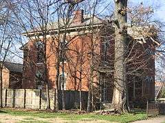
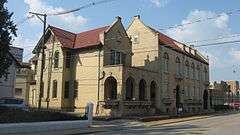
| 1 |
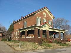
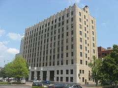
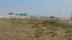
Albion Flats |
|
000000001982-07-01-0000July 1, 1982
(#82000093) |
701 Court St.
37°58′33″N 87°34′10″W / 37.975833°N 87.569444°W / 37.975833; -87.569444 (Albion Flats) |
Evansville |
|
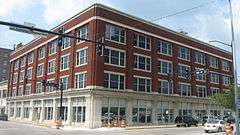
| 2 |
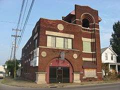
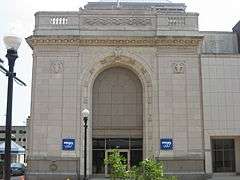
Alhambra Theatorium |
|
000000001979-10-01-0000October 1, 1979
(#79000047) |
50 Adams Ave.
37°57′44″N 87°33′57″W / 37.962222°N 87.565833°W / 37.962222; -87.565833 (Alhambra Theatorium) |
Evansville |
|
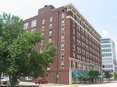
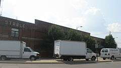
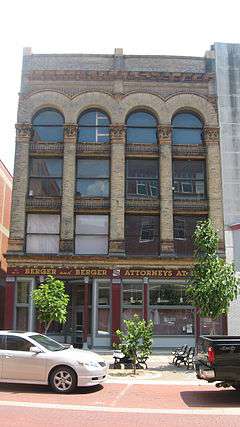
| 3 |
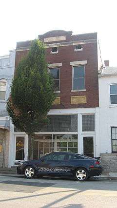
American Trust and Savings Bank (Indiana Bank) |
|
000000001982-07-01-0000July 1, 1982
(#82000094) |
524-530 Main St.
37°58′22″N 87°34′09″W / 37.972778°N 87.569167°W / 37.972778; -87.569167 (American Trust and Savings Bank (Indiana Bank)) |
Evansville |
|
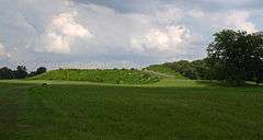
| 4 |
Angel Mounds |
|
000000001966-10-15-0000October 15, 1966
(#66000124) |
8215 Pollack Ave.[6]
37°56′31″N 87°27′35″W / 37.941944°N 87.459722°W / 37.941944; -87.459722 (Angel Mounds) |
Knight Township |
Extends into Warrick County
|
| 5 |
Auto Hotel Building |
|
000000001984-04-06-0000April 6, 1984
(#84001673) |
111-115 SE. 3rd St.
37°58′10″N 87°34′18″W / 37.969444°N 87.571667°W / 37.969444; -87.571667 (Auto Hotel Building) |
Evansville |
|
| 6 |
Barrett's Britz Building |
|
000000001984-04-06-0000April 6, 1984
(#84001679) |
415 Main St.
37°58′18″N 87°34′14″W / 37.971667°N 87.570556°W / 37.971667; -87.570556 (Barrett's Britz Building) |
Evansville |
|
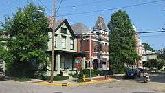
| 7 |
Bayard Park Historic District |
|
000000001985-06-27-0000June 27, 1985
(#85001373) |
Roughly bounded by Gum, Kentucky, Blackford, and Garvin Sts.
37°57′56″N 87°33′06″W / 37.965556°N 87.551667°W / 37.965556; -87.551667 (Bayard Park Historic District) |
Evansville |
|
| 8 |
William Bedford Sr. House |
|
000000001978-11-28-0000November 28, 1978
(#78000056) |
838 Washington Ave.
37°57′49″N 87°33′03″W / 37.963611°N 87.550833°W / 37.963611; -87.550833 (William Bedford Sr. House) |
Evansville |
|
| 9 |
Bernardin-Johnson House |
|
000000001989-06-27-0000June 27, 1989
(#89000238) |
17 Johnson Pl.
37°58′15″N 87°31′24″W / 37.970833°N 87.523333°W / 37.970833; -87.523333 (Bernardin-Johnson House) |
Evansville |
|
| 10 |
Bitterman Building |
|
000000001980-09-22-0000September 22, 1980
(#80000068) |
202-204 Main St.
37°58′14″N 87°34′23″W / 37.970694°N 87.573194°W / 37.970694; -87.573194 (Bitterman Building) |
Evansville |
|
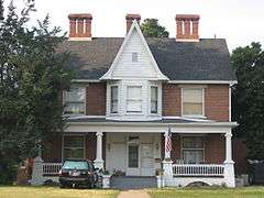
| 11 |
Glenn A. Black House |
|
000000002011-12-21-0000December 21, 2011
(#11000660) |
8215 Pollack Ave., southeast of Evansville
37°56′51″N 87°27′10″W / 37.947500°N 87.452778°W / 37.947500; -87.452778 (Glenn A. Black House) |
Knight Township |
|
| 12 |
John W. Boehne House |
|
000000001983-02-17-0000February 17, 1983
(#83000105) |
1119 Lincoln Ave.
37°58′10″N 87°32′42″W / 37.969444°N 87.545°W / 37.969444; -87.545 (John W. Boehne House) |
Evansville |
|
| 13 |
Building at 223 Main Street |
|
000000001982-07-01-0000July 1, 1982
(#82000083) |
223 Main St.
37°58′15″N 87°34′21″W / 37.970778°N 87.572389°W / 37.970778; -87.572389 (Building at 223 Main Street) |
Evansville |
|
| 14 |
Busse House |
|
000000001982-07-01-0000July 1, 1982
(#82000084) |
120 SE 1st St.
37°58′07″N 87°34′23″W / 37.968611°N 87.573056°W / 37.968611; -87.573056 (Busse House) |
Evansville |
|
| 15 |
Cadick Apartments (Plaza Building) |
|
000000001982-07-01-0000July 1, 1982
(#82000085) |
118 SE. 1st St.
37°58′08″N 87°34′23″W / 37.96875°N 87.573056°W / 37.96875; -87.573056 (Cadick Apartments (Plaza Building)) |
Evansville |
|
| 16 |
Willard Carpenter House |
|
000000001978-02-10-0000February 10, 1978
(#78000057) |
405 Carpenter St.
37°58′30″N 87°34′32″W / 37.975000°N 87.575556°W / 37.975000; -87.575556 (Willard Carpenter House) |
Evansville |
|
| 17 |
Central Library |
|
000000001982-07-01-0000July 1, 1982
(#82000086) |
22 SE. 5th St.
37°58′17″N 87°34′09″W / 37.971389°N 87.569167°W / 37.971389; -87.569167 (Central Library) |
Evansville |
|
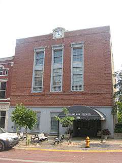
| 18 |
Citizens National Bank |
|
000000001982-07-01-0000July 1, 1982
(#82000087) |
329 Main St.
37°58′17″N 87°34′16″W / 37.971389°N 87.571111°W / 37.971389; -87.571111 (Citizens National Bank) |
Evansville |
Now Hilliard-Lyons Building
|
| 19 |
Conner's Bookstore |
|
000000001984-04-06-0000April 6, 1984
(#84001684) |
611-613 Main St.
37°58′22″N 87°34′08″W / 37.972778°N 87.568889°W / 37.972778; -87.568889 (Conner's Bookstore) |
Evansville |
|
| 20 |
Court Building (Furniture Building) |
|
000000001982-07-01-0000July 1, 1982
(#82000088) |
123-125 NW. 4th St.
37°58′23″N 87°34′20″W / 37.973194°N 87.572222°W / 37.973194; -87.572222 (Court Building (Furniture Building)) |
Evansville |
|
| 21 |
Culver Historic District |
|
000000001984-06-01-0000June 1, 1984
(#84001691) |
Roughly bounded by Madison Ave., Riverside Dr., and Emmett and Venice Sts.
37°57′31″N 87°33′52″W / 37.958611°N 87.564444°W / 37.958611; -87.564444 (Culver Historic District) |
Evansville |
|
| 22 |
Eagles Home |
|
000000001982-07-01-0000July 1, 1982
(#82000090) |
221 NW. 5th St.
37°58′28″N 87°34′18″W / 37.974444°N 87.571667°W / 37.974444; -87.571667 (Eagles Home) |
Evansville |
|
| 23 |
Evansville Brewing Company |
|
000000001982-07-01-0000July 1, 1982
(#82000091) |
401 NW. 4th St.
37°58′32″N 87°34′24″W / 37.975556°N 87.573333°W / 37.975556; -87.573333 (Evansville Brewing Company) |
Evansville |
|
| 24 |
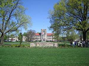
Evansville College |
|
000000001983-02-03-0000February 3, 1983
(#83000106) |
1800 Lincoln Ave.
37°58′17″N 87°31′54″W / 37.971389°N 87.531667°W / 37.971389; -87.531667 (Evansville College) |
Evansville |
|
| 25 |
Evansville Journal News |
|
000000001982-07-01-0000July 1, 1982
(#82000092) |
7-11 NW. 5th St.
37°58′21″N 87°34′13″W / 37.972500°N 87.570139°W / 37.972500; -87.570139 (Evansville Journal News) |
Evansville |
|
| 26 |
Evansville Municipal Market |
|
000000001983-12-22-0000December 22, 1983
(#83003771) |
813 Pennsylvania St.
37°58′41″N 87°34′33″W / 37.978056°N 87.575833°W / 37.978056; -87.575833 (Evansville Municipal Market) |
Evansville |
|
| 27 |
Evansville Post Office |
|
000000001971-07-02-0000July 2, 1971
(#71000010) |
100 block of NW. 2nd St.
37°58′18″N 87°34′28″W / 37.971667°N 87.574444°W / 37.971667; -87.574444 (Evansville Post Office) |
Evansville |
|
| 28 |
Fellwock Garage |
|
000000001984-04-06-0000April 6, 1984
(#84001701) |
315 Court St.
37°58′25″N 87°34′24″W / 37.973611°N 87.573333°W / 37.973611; -87.573333 (Fellwock Garage) |
Evansville |
|
| 29 |
Firestone Tire and Rubber Store |
|
000000001984-04-06-0000April 6, 1984
(#84001702) |
900 Main St.
37°58′30″N 87°33′57″W / 37.975°N 87.565972°W / 37.975; -87.565972 (Firestone Tire and Rubber Store) |
Evansville |
|
| 30 |
Former Vanderburgh County Sheriff's Residence |
|
000000001970-10-06-0000October 6, 1970
(#70000009) |
4th St. between Vine and Court Sts.
37°58′24″N 87°34′22″W / 37.973472°N 87.572778°W / 37.973472; -87.572778 (Former Vanderburgh County Sheriff's Residence) |
Evansville |
|
| 31 |
Garvin Park |
|
000000001980-08-29-0000August 29, 1980
(#80000069) |
N. Main St. and Morgan Ave.
37°59′43″N 87°33′50″W / 37.995278°N 87.563889°W / 37.995278; -87.563889 (Garvin Park) |
Evansville |
|
| 32 |
Fred Geiger and Sons National Biscuit Company |
|
000000001982-07-01-0000July 1, 1982
(#82000096) |
401 NW. 2nd St.
37°58′26″N 87°34′33″W / 37.973889°N 87.575833°W / 37.973889; -87.575833 (Fred Geiger and Sons National Biscuit Company) |
Evansville |
|
| 33 |
Gemcraft-Wittmer Building |
|
000000001984-04-06-0000April 6, 1984
(#84001704) |
609 Main St.
37°58′22″N 87°34′07″W / 37.972778°N 87.568611°W / 37.972778; -87.568611 (Gemcraft-Wittmer Building) |
Evansville |
|
| 34 |
General Cigar Company |
|
000000002000-03-15-0000March 15, 2000
(#00000212) |
223 NW. 2nd St.
37°58′22″N 87°34′30″W / 37.972778°N 87.575°W / 37.972778; -87.575 (General Cigar Company) |
Evansville |
|
| 35 |
German Bank |
|
000000001982-07-01-0000July 1, 1982
(#82000097) |
301-303 Main St.
37°58′15″N 87°34′19″W / 37.970833°N 87.571944°W / 37.970833; -87.571944 (German Bank) |
Evansville |
|
| 36 |
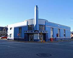
Greyhound Bus Terminal |
|
000000001979-10-01-0000October 1, 1979
(#79000048) |
102 NW. 3rd St.
37°58′19″N 87°34′24″W / 37.971944°N 87.573333°W / 37.971944; -87.573333 (Greyhound Bus Terminal) |
Evansville |
|
| 37 |
Harding and Miller Music Company |
|
000000001982-07-01-0000July 1, 1982
(#82000098) |
518-520 Main St.
37°58′21″N 87°34′10″W / 37.972583°N 87.569444°W / 37.972583; -87.569444 (Harding and Miller Music Company) |
Evansville |
|
| 38 |
Michael D. Helfrich House |
|
000000001984-05-24-0000May 24, 1984
(#84001710) |
700 Helfrich Lane
37°59′05″N 87°36′23″W / 37.984722°N 87.606389°W / 37.984722; -87.606389 (Michael D. Helfrich House) |
Evansville |
|
| 39 |
Hooker-Ensle-Pierce House |
|
000000001977-04-28-0000April 28, 1977
(#77000022) |
6531 Oak Hill Rd., north of Evansville
38°02′13″N 87°30′32″W / 38.036944°N 87.508889°W / 38.036944; -87.508889 (Hooker-Ensle-Pierce House) |
Center Township |
|
| 40 |
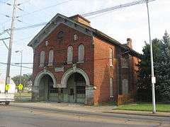
Hose House No. 10 |
|
000000001982-02-11-0000February 11, 1982
(#82000099) |
119 E. Columbia St.
37°59′04″N 87°33′41″W / 37.984444°N 87.561389°W / 37.984444; -87.561389 (Hose House No. 10) |
Evansville |
|
| 41 |
Hose House No. 12 |
|
000000001982-06-17-0000June 17, 1982
(#82000100) |
1409 1st Ave.
37°59′28″N 87°34′28″W / 37.991111°N 87.574444°W / 37.991111; -87.574444 (Hose House No. 12) |
Evansville |
|
| 42 |
Huber Motor Sales Building |
|
000000001984-04-06-0000April 6, 1984
(#84001715) |
215-219 SE. 4th St.
37°58′09″N 87°34′10″W / 37.969167°N 87.569444°W / 37.969167; -87.569444 (Huber Motor Sales Building) |
Evansville |
|
| 43 |
Edgar A. Igleheart House |
|
000000001990-12-18-0000December 18, 1990
(#90001930) |
5500 Lincoln Ave.
37°58′13″N 87°29′01″W / 37.970278°N 87.483611°W / 37.970278; -87.483611 (Edgar A. Igleheart House) |
Evansville |
|
| 44 |
Independence Historic District |
|
000000001982-02-01-0000February 1, 1982
(#82000102) |
W. Franklin St. and Wabash Ave.
37°58′52″N 87°35′46″W / 37.981111°N 87.596111°W / 37.981111; -87.596111 (Independence Historic District) |
Evansville |
|
| 45 |
Indiana Bell Building |
|
000000001982-07-01-0000July 1, 1982
(#82000103) |
129-133 NW. 5th St.
37°58′25″N 87°34′16″W / 37.973611°N 87.571111°W / 37.973611; -87.571111 (Indiana Bell Building) |
Evansville |
|
| 46 |
Ingle Terrace |
|
000000001982-07-01-0000July 1, 1982
(#82000104) |
609-619 Ingle St.
37°58′34″N 87°34′16″W / 37.976111°N 87.571111°W / 37.976111; -87.571111 (Ingle Terrace) |
Evansville |
|
| 47 |
Koester/Patburg House |
|
000000001983-03-03-0000March 3, 1983
(#83000151) |
504 Herndon Dr.
37°59′49″N 87°33′25″W / 37.996944°N 87.556944°W / 37.996944; -87.556944 (Koester/Patburg House) |
Evansville |
|
| 48 |
Kuebler-Artes Building |
|
000000001984-04-06-0000April 6, 1984
(#84002895) |
327 Main St.
37°58′17″N 87°34′16″W / 37.971333°N 87.571222°W / 37.971333; -87.571222 (Kuebler-Artes Building) |
Evansville |
|
| 49 |
August Kuehn House |
|
000000001982-07-01-0000July 1, 1982
(#82000105) |
608-610 Ingle St.
37°58′36″N 87°34′17″W / 37.976667°N 87.571389°W / 37.976667; -87.571389 (August Kuehn House) |
Evansville |
|
| 50 |
Charles Leich and Company |
|
000000001982-07-01-0000July 1, 1982
(#82000106) |
420 NW. 5th St.
37°58′34″N 87°34′25″W / 37.976111°N 87.573611°W / 37.976111; -87.573611 (Charles Leich and Company) |
Evansville |
|
| 51 |
Liberty Baptist Church |
|
000000001978-12-08-0000December 8, 1978
(#78000058) |
701 Oak St.
37°58′08″N 87°33′51″W / 37.968889°N 87.564167°W / 37.968889; -87.564167 (Liberty Baptist Church) |
Evansville |
|
| 52 |
Lincolnshire Historic District |
|
000000001989-10-02-0000October 2, 1989
(#89001426) |
Roughly bounded by Lincoln, Bennighof, Bellemeade, Lodge, Washington, Harlan, E. Chandler, and College
37°58′01″N 87°32′24″W / 37.966944°N 87.54°W / 37.966944; -87.54 (Lincolnshire Historic District) |
Evansville |
|
| 53 |
Lockyear College |
|
000000001984-04-06-0000April 6, 1984
(#84001729) |
209 NW. 5th St.
37°58′28″N 87°34′17″W / 37.974444°N 87.571389°W / 37.974444; -87.571389 (Lockyear College) |
Evansville |
|
| 54 |
Peter Augustus Maier House |
|
000000001982-10-29-0000October 29, 1982
(#82000107) |
707 S. 6th St.
37°57′59″N 87°33′51″W / 37.966389°N 87.564167°W / 37.966389; -87.564167 (Peter Augustus Maier House) |
Evansville |
|
| 55 |
Masonic Temple |
|
000000001982-07-01-0000July 1, 1982
(#82000108) |
301 Chestnut St.
37°58′07″N 87°34′11″W / 37.968611°N 87.569722°W / 37.968611; -87.569722 (Masonic Temple) |
Evansville |
|
| 56 |
McCurdy Building (Sears, Roebuck and Company Building) |
|
000000001979-10-01-0000October 1, 1979
(#79000050) |
101 NW. 4th St.
37°58′22″N 87°34′19″W / 37.972778°N 87.571944°W / 37.972778; -87.571944 (McCurdy Building (Sears, Roebuck and Company Building)) |
Evansville |
|
| 57 |
McCurdy Hotel |
|
000000001982-07-01-0000July 1, 1982
(#82000109) |
101-111 SE. 1st St.
37°58′08″N 87°34′25″W / 37.968889°N 87.573611°W / 37.968889; -87.573611 (McCurdy Hotel) |
Evansville |
|
| 58 |
McJohnston Chapel and Cemetery |
|
000000001979-01-18-0000January 18, 1979
(#79000051) |
Kansas Rd. and Erskine Lane at McCutchanville
38°03′51″N 87°31′23″W / 38.064167°N 87.523056°W / 38.064167; -87.523056 (McJohnston Chapel and Cemetery) |
Center Township |
|
| 59 |
Mead Johnson River-Rail-Truck Terminal and Warehouse |
|
000000001984-12-27-0000December 27, 1984
(#84000495) |
1830 W. Ohio St.
37°58′35″N 87°35′31″W / 37.976389°N 87.591944°W / 37.976389; -87.591944 (Mead Johnson River-Rail-Truck Terminal and Warehouse) |
Evansville |
|
| 60 |
Montgomery Ward Building |
|
000000001982-10-06-0000October 6, 1982
(#82000110) |
517 Main St.
37°58′20″N 87°34′09″W / 37.972222°N 87.569167°W / 37.972222; -87.569167 (Montgomery Ward Building) |
Evansville |
|
| 61 |
Morris Plan (Central Union Bank) |
|
000000001982-07-01-0000July 1, 1982
(#82000111) |
20 NW 4th St.
37°58′20″N 87°34′19″W / 37.972222°N 87.571944°W / 37.972222; -87.571944 (Morris Plan (Central Union Bank)) |
Evansville |
|
| 62 |
National City Bank |
|
000000001982-07-01-0000July 1, 1982
(#82000112) |
227 Main St.
37°58′15″N 87°34′20″W / 37.970833°N 87.572222°W / 37.970833; -87.572222 (National City Bank) |
Evansville |
|
| 63 |
M.G. Newman Building |
|
000000001982-07-01-0000July 1, 1982
(#82000113) |
211-213 SE. 4th St.
37°58′10″N 87°34′10″W / 37.969444°N 87.569583°W / 37.969444; -87.569583 (M.G. Newman Building) |
Evansville |
|
| 64 |
O'Donnell Building |
|
000000001982-07-01-0000July 1, 1982
(#82000115) |
22 NW. 6th St.
37°58′24″N 87°34′10″W / 37.973333°N 87.569583°W / 37.973333; -87.569583 (O'Donnell Building) |
Evansville |
|
| 65 |
Oak Hill Cemetery |
|
000000002004-03-22-0000March 22, 2004
(#04000205) |
1400 E. Virginia St.
37°59′17″N 87°32′14″W / 37.988056°N 87.537222°W / 37.988056; -87.537222 (Oak Hill Cemetery) |
Evansville |
|
| 66 |
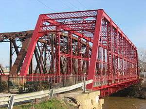
Ohio Street Bridge |
|
000000001998-12-17-0000December 17, 1998
(#98001523) |
Ohio St. over Pigeon Creek
37°58′34″N 87°35′16″W / 37.976111°N 87.587778°W / 37.976111; -87.587778 (Ohio Street Bridge) |
Evansville |
|
| 67 |
Old Bittermann Building |
|
000000001980-09-22-0000September 22, 1980
(#80000070) |
200 Main St.
37°58′14″N 87°34′24″W / 37.970694°N 87.573333°W / 37.970694; -87.573333 (Old Bittermann Building) |
Evansville |
|
| 68 |
Old Fellwock Auto Company |
|
000000001984-04-06-0000April 6, 1984
(#84001735) |
214 NW. 4th St.
37°58′25″N 87°34′23″W / 37.973611°N 87.573056°W / 37.973611; -87.573056 (Old Fellwock Auto Company) |
Evansville |
|
| 69 |
Old Vanderburgh County Courthouse |
|
000000001970-09-04-0000September 4, 1970
(#70000010) |
Entire block bounded by Vine, 4th, Court, and 5th Sts.
37°58′26″N 87°34′20″W / 37.973889°N 87.572222°W / 37.973889; -87.572222 (Old Vanderburgh County Courthouse) |
Evansville |
|
| 70 |
Orr Iron Company |
|
000000001982-07-01-0000July 1, 1982
(#82000116) |
1100 Pennsylvania St.
37°58′37″N 87°34′51″W / 37.976944°N 87.580833°W / 37.976944; -87.580833 (Orr Iron Company) |
Evansville |
|
| 71 |
Parson and Scoville Building |
|
000000001982-07-01-0000July 1, 1982
(#82000117) |
915 Main St.
37°58′30″N 87°33′53″W / 37.975°N 87.564722°W / 37.975; -87.564722 (Parson and Scoville Building) |
Evansville |
|
| 72 |
Pearl Steam Laundry |
|
000000001984-04-06-0000April 6, 1984
(#84001738) |
428 Market St.
37°58′31″N 87°34′30″W / 37.975278°N 87.575°W / 37.975278; -87.575 (Pearl Steam Laundry) |
Evansville |
|
| 73 |
L. Puster and Company Furniture Manufactory |
|
000000001982-07-01-0000July 1, 1982
(#82000118) |
326 NW. 6th St.
37°58′33″N 87°34′18″W / 37.975833°N 87.571667°W / 37.975833; -87.571667 (L. Puster and Company Furniture Manufactory) |
Evansville |
|
| 74 |
John Augustus Reitz House |
|
000000001973-10-15-0000October 15, 1973
(#73000047) |
224 SE. 1st St.
37°58′04″N 87°34′20″W / 37.967778°N 87.572222°W / 37.967778; -87.572222 (John Augustus Reitz House) |
Evansville |
|
| 75 |
Ridgway Building |
|
000000001980-01-03-0000January 3, 1980
(#80000071) |
313-315 Main St.
37°58′16″N 87°34′18″W / 37.971111°N 87.571667°W / 37.971111; -87.571667 (Ridgway Building) |
Evansville |
|
| 76 |
Riverside Historic District |
|
000000001978-11-14-0000November 14, 1978
(#78000059) |
Roughly bounded by Southlane Dr. and Walnut, 3rd., and Parrett Sts.
37°57′50″N 87°34′10″W / 37.963889°N 87.569444°W / 37.963889; -87.569444 (Riverside Historic District) |
Evansville |
|
| 77 |
John H. Roelker House |
|
000000001984-04-06-0000April 6, 1984
(#84001741) |
555 Sycamore St.
37°58′24″N 87°34′11″W / 37.973333°N 87.569722°W / 37.973333; -87.569722 (John H. Roelker House) |
Evansville |
|
| 78 |
Rose Terrace |
|
000000001982-07-01-0000July 1, 1982
(#82000120) |
301-313 NW. 7th St.
37°58′34″N 87°34′12″W / 37.976111°N 87.57°W / 37.976111; -87.57 (Rose Terrace) |
Evansville |
|
| 79 |
St. John's Evangelical Protestant Church |
|
000000001982-07-01-0000July 1, 1982
(#82000123) |
314 Market St.
37°58′28″N 87°34′28″W / 37.974444°N 87.574444°W / 37.974444; -87.574444 (St. John's Evangelical Protestant Church) |
Evansville |
|
| 80 |
Salem's Baptist Church |
|
000000001982-07-01-0000July 1, 1982
(#82000121) |
728 Court St.
37°58′35″N 87°34′09″W / 37.976389°N 87.569167°W / 37.976389; -87.569167 (Salem's Baptist Church) |
Evansville |
|
| 81 |
Michael Schaeffer House |
|
000000001982-02-11-0000February 11, 1982
(#82001854) |
118 E. Chandler St.
37°57′58″N 87°33′47″W / 37.966111°N 87.563056°W / 37.966111; -87.563056 (Michael Schaeffer House) |
Evansville |
|
| 82 |
Siegel's Department Store |
|
000000001982-07-04-0000July 4, 1982
(#82000122) |
101-105 SE. 4th St.
37°58′14″N 87°34′14″W / 37.970556°N 87.570556°W / 37.970556; -87.570556 (Siegel's Department Store) |
Evansville |
|
| 83 |
Robert Smith Mortuary |
|
000000001980-09-22-0000September 22, 1980
(#80000072) |
118-120 Walnut St.
37°58′08″N 87°34′20″W / 37.968889°N 87.572222°W / 37.968889; -87.572222 (Robert Smith Mortuary) |
Evansville |
|
| 84 |
Soldiers and Sailors Memorial Coliseum |
|
000000001979-05-10-0000May 10, 1979
(#79000052) |
350 Court St.
37°58′27″N 87°34′24″W / 37.974167°N 87.573333°W / 37.974167; -87.573333 (Soldiers and Sailors Memorial Coliseum) |
Evansville |
|
| 85 |
Sunset Park Pavilion |
|
000000001992-06-17-0000June 17, 1992
(#92000673) |
411 SE. Riverside Dr. in Sunset Park
37°57′57″N 87°34′26″W / 37.965833°N 87.573889°W / 37.965833; -87.573889 (Sunset Park Pavilion) |
Evansville |
|
| 86 |
Charles Sweeton House |
|
000000002005-03-25-0000March 25, 2005
(#05000196) |
8700 Old State Rd., north of Evansville
38°03′30″N 87°33′42″W / 38.058333°N 87.561667°W / 38.058333; -87.561667 (Charles Sweeton House) |
Center Township |
|
| 87 |
USS LST 325 (tank landing ship) |
|
000000002009-06-24-0000June 24, 2009
(#09000434) |
840 LST Drive, south of Evansville
37°57′11″N 87°34′36″W / 37.953056°N 87.576667°W / 37.953056; -87.576667 (USS LST 325 (tank landing ship)) |
Pigeon Township |
|
| 88 |
Van Cleave Flats |
|
000000001982-07-01-0000July 1, 1982
(#82000125) |
704-708 Court St.
37°58′33″N 87°34′11″W / 37.975972°N 87.569722°W / 37.975972; -87.569722 (Van Cleave Flats) |
Evansville |
|
| 89 |
Victory Theater and Hotel Sonntag |
|
000000001982-07-01-0000July 1, 1982
(#82000124) |
600-614 Main St.
37°58′22″N 87°34′08″W / 37.972778°N 87.568889°W / 37.972778; -87.568889 (Victory Theater and Hotel Sonntag) |
Evansville |
|
| 90 |
Washington Avenue Historic District |
|
000000001980-11-28-0000November 28, 1980
(#80000073) |
Roughly bounded by Madison and Grand Aves., E. Gum and Parret Sts.
37°57′51″N 87°33′27″W / 37.964167°N 87.5575°W / 37.964167; -87.5575 (Washington Avenue Historic District) |
Evansville |
|
| 91 |
Willard Library |
|
000000001972-09-28-0000September 28, 1972
(#72000014) |
21 1st Ave.
37°58′42″N 87°34′27″W / 37.978333°N 87.574167°W / 37.978333; -87.574167 (Willard Library) |
Evansville |
|
| 92 |
YMCA |
|
000000001982-07-01-0000July 1, 1982
(#82000128) |
203 NW. 5th St.
37°58′27″N 87°34′17″W / 37.974167°N 87.571389°W / 37.974167; -87.571389 (YMCA) |
Evansville |
|
| 93 |
YWCA |
|
000000001982-07-01-0000July 1, 1982
(#82001853) |
118 Vine St.
37°58′20″N 87°34′31″W / 37.972222°N 87.575278°W / 37.972222; -87.575278 (YWCA) |
Evansville |
|
| 94 |
Zion Evangelical Church |
|
000000001982-07-01-0000July 1, 1982
(#82000129) |
415 NW. 5th St.
37°58′34″N 87°34′23″W / 37.976111°N 87.573056°W / 37.976111; -87.573056 (Zion Evangelical Church) |
Evansville |
|