Mansfield Covered Bridge
| Mansfield Covered Bridge | |
| National Register of Historic Places | |
.jpg) Mansfield Covered Bridge | |
| Official name: Mansfield Covered Bridge | |
| Named for: Mansfield, Indiana | |
| Country | |
|---|---|
| State | |
| County | Parke |
| Township | Jackson |
| Road | Martin Road (C.R. 145) |
| City | Mansfield, Indiana |
| Crosses | Big Raccoon Creek |
| Coordinates | 39°40′32.25″N 87°6′6.4″W / 39.6756250°N 87.101778°WCoordinates: 39°40′32.25″N 87°6′6.4″W / 39.6756250°N 87.101778°W |
| Length | 279 ft (85 m) 247ft +16ft overhangs on each end |
| Width | 16 ft (5 m) [1] |
| Clearance | 14 ft (4 m) |
| Load | 10 tons |
| Builder | Daniels, J.J. |
| Design | Double Burr Arch truss double span bridge |
| Material | Wood |
| Built | September 4, 1867 Original cost $12,200 |
| - Rebuilt | 1990 |
| Owned and Maintained by | Parke County |
| NBI Number | 6100089[2] |
| WGCB Number | #14-61-20 [3] |
| Added to NRHP | Dec 22, 1978 |
| NRHP Ref# | 78000399[4] |
| MPS | Parke County Covered Bridges TR |
 Location of the Mansfield Bridge in Indiana | |
 Location of Indiana in the United States | |
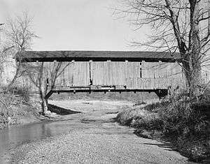
The Mansfield Covered Bridge is a Double Burr Arch double span truss bridge located on Mansfield Road (historic) and Big Raccoon Creek in Mansfield southeast of Rockville in Parke County, Indiana. Built by Joseph J. Daniels in 1867 at a cost of $12,200. At 279 ft (85 m) it is the longest covered bridge left in Parke County. [1][5]
History
Built for a time where only wagons, horses and pedestrians whould have used the bridge the Mansfield Bridge has a 10-short-ton (9.1 t) load limit. The bridge had been used for State Route 59 and in one recorded story, three loaded oil trucks approached the bridge together. The first truck stalled out just before leaving the bridge, and all three trucks came to a stop on the two spans. There was no apparent damage to the strong structure. The arches combined with the truss are able to support more weight than needed so the limit is in the decking and material used for it.[3]
Mansfield Bridge was closed in 1980 for repair to the abutments, roof and decking. The roof and decks were replaced again in October 1990 by the Parke County Highway Department.
It was added to the National Register of Historic Places in 1978.[4]
Gallery
The Mansfield Covered Bridge
|
_P4230017_Mansfield_CB_(Parke_Cty).jpg)
_P4230125_Mansfield_CB_(Parke_Cty).jpg)
See also
- Big Rocky Fork Covered Bridge
- Mansfield Roller Mill
- Pleasant Valley Cemetery
- Parke County Covered Bridges
- List of Registered Historic Places in Indiana
- Parke County Covered Bridge Festival
References
- 1 2 "Mansfield Covered Bridge (#5)". coveredbridges.com. Parke County Incorporated / Parke County Convention and Visitors Commission. Retrieved 21 September 2016.
- ↑ http://nationalbridges.com/
- 1 2 http://www.indianacrossings.org/bridgeLinks/14-61-20.html
- 1 2 National Park Service (2007-01-23). "National Register Information System". National Register of Historic Places. National Park Service.
- ↑ "Indiana State Historic Architectural and Archaeological Research Database (SHAARD)" (Searchable database). Department of Natural Resources, Division of Historic Preservation and Archaeology. Retrieved 2016-06-01. Note: This includes Charles Felkner (December 1977). "National Register of Historic Places Inventory Nomination Form: Parke County Covered Bridge Historic District" (PDF). Retrieved 2016-06-01. and Site map.
External links
 Media related to Mansfield Covered Bridge at Wikimedia Commons
- Historic American Engineering Record (HAER) No. IN-44, "Mansfield Covered Bridge, Spanning Big Raccoon Creek, Mansfield, Parke County, IN"
- Parke County Covered Bridge Festival
- Official website