| [3] |
Name on the Register[4] |
Image |
Date listed[5] |
Location |
City or town |
Description |
|---|
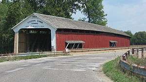
| 1 |
Arch in the Town of Marshall |
|
000000001985-12-26-0000December 26, 1985
(#85003127) |
Main and Guion Sts.
39°50′51″N 87°11′15″W / 39.847500°N 87.187500°W / 39.847500; -87.187500 (Arch in the Town of Marshall) |
Marshall |
|
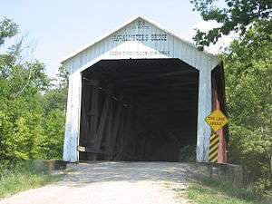
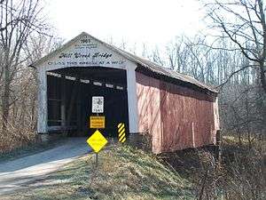
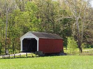
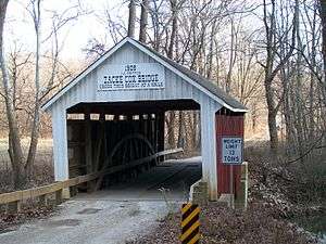
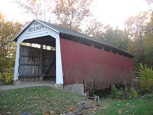
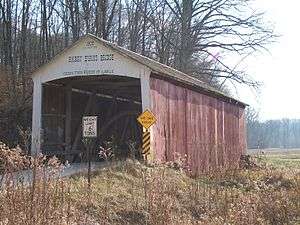
| 2 |
Beeson Bridge |
|
000000001978-12-22-0000December 22, 1978
(#78003447) |
East of Rockville at Billie Creek Village
39°45′48″N 87°12′23″W / 39.763222°N 87.206389°W / 39.763222; -87.206389 (Beeson Bridge) |
Adams Township |
|
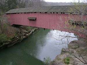
| 3 |
Big Rocky Fork Bridge |
|
000000001978-12-22-0000December 22, 1978
(#78000383) |
Southeast of Mansfield on Greencastle Rd.
39°40′32″N 87°06′06″W / 39.675556°N 87.101667°W / 39.675556; -87.101667 (Big Rocky Fork Bridge) |
Jackson Township |
|
| 4 |
Billie Creek Bridge |
|
000000001978-12-22-0000December 22, 1978
(#78000384) |
East of Rockville off U.S. Route 36 at Billie Creek Village
39°45′41″N 87°12′23″W / 39.761389°N 87.206389°W / 39.761389; -87.206389 (Billie Creek Bridge) |
Adams Township |
|
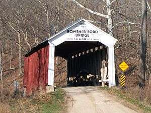
| 5 |
Bowsher Ford Bridge |
|
000000001978-12-22-0000December 22, 1978
(#78000385) |
North of Rockville
39°55′47″N 87°21′06″W / 39.929722°N 87.351667°W / 39.929722; -87.351667 (Bowsher Ford Bridge) |
Liberty Township |
|
| 6 |
Bridgeton Bridge |
|
000000001978-12-22-0000December 22, 1978
(#78000386) |
North of Bridgeton
39°38′58″N 87°10′34″W / 39.649444°N 87.176111°W / 39.649444; -87.176111 (Bridgeton Bridge) |
Raccoon Township |
Arsoned in 2005
|
| 7 |
Bridgeton Historic District |
|
000000001992-09-04-0000September 4, 1992
(#92001167) |
Roughly bounded by the northern bank of Big Raccoon Creek, George and Clark Sts., Mill Alley, and the alley east of Main St. at Bridgeton
39°38′54″N 87°10′35″W / 39.648333°N 87.176389°W / 39.648333; -87.176389 (Bridgeton Historic District) |
Raccoon Township |
|
| 8 |
Catlin Bridge |
|
000000001978-12-22-0000December 22, 1978
(#78000387) |
North of Rockville off U.S. Route 41
39°47′30″N 87°14′18″W / 39.791667°N 87.238333°W / 39.791667; -87.238333 (Catlin Bridge) |
Adams Township |
|
| 9 |
Conley's Ford Bridge |
|
000000001978-12-22-0000December 22, 1978
(#78000388) |
East of Bridgeton
39°39′34″N 87°07′59″W / 39.659444°N 87.133056°W / 39.659444; -87.133056 (Conley's Ford Bridge) |
Raccoon Township |
|
| 10 |
Cox Ford Bridge |
|
000000001978-12-22-0000December 22, 1978
(#78000390) |
North of Rockville off U.S. Route 41
39°53′07″N 87°13′25″W / 39.885278°N 87.223611°W / 39.885278; -87.223611 (Cox Ford Bridge) |
Penn Township |
|
| 11 |
Crooks Bridge |
|
000000001978-12-22-0000December 22, 1978
(#78000391) |
North of Bridgeton
39°43′26″N 87°11′22″W / 39.723889°N 87.189444°W / 39.723889; -87.189444 (Crooks Bridge) |
Adams Township |
|
| 12 |
Lancelot C. Ewbank House |
|
000000001988-09-26-0000September 26, 1988
(#88001578) |
County Road 102E between 1200N and 300E, east of Tangier
39°55′24″N 87°12′58″W / 39.923333°N 87.216111°W / 39.923333; -87.216111 (Lancelot C. Ewbank House) |
Sugar Creek Township |
|
| 13 |
Joseph Finney House |
|
000000002002-12-20-0000December 20, 2002
(#02001564) |
County Road 217, northwest of Bloomingdale
39°51′35″N 87°16′18″W / 39.859722°N 87.271667°W / 39.859722; -87.271667 (Joseph Finney House) |
Penn Township |
|
| 14 |
Harry Evans Bridge |
|
000000001978-12-22-0000December 22, 1978
(#78000392) |
Southeast of Mecca off Old Greencastle Rd.
39°39′43″N 87°17′40″W / 39.661944°N 87.294444°W / 39.661944; -87.294444 (Harry Evans Bridge) |
Florida Township |
|
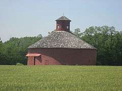
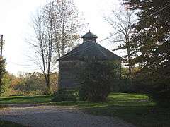
| 15 |
William Hill Polygonal Barn |
|
000000001993-04-02-0000April 2, 1993
(#93000186) |
Academy St.
39°49′48″N 87°15′05″W / 39.830000°N 87.251389°W / 39.830000; -87.251389 (William Hill Polygonal Barn) |
Bloomingdale |
|
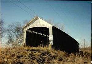
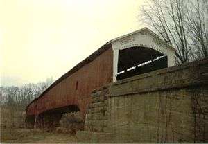
| 16 |
Jackson Bridge |
|
000000001978-12-22-0000December 22, 1978
(#78000393) |
North of Rockville
39°52′48″N 87°16′57″W / 39.88°N 87.2825°W / 39.88; -87.2825 (Jackson Bridge) |
Penn Township |
Longest single span covered bridge in Indiana
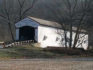
|
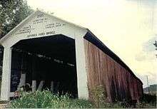
| 17 |
Jeffries Ford Bridge |
|
000000001978-12-22-0000December 22, 1978
(#78000394) |
Southwest of Bridgeton
39°37′49″N 87°12′30″W / 39.630278°N 87.208333°W / 39.630278; -87.208333 (Jeffries Ford Bridge) |
Raccoon Township |
|
| 18 |
Leatherwood Station Bridge |
|
000000001978-12-22-0000December 22, 1978
(#78000397) |
East of Rockville at Billie Creek Village
39°48′54″N 87°17′56″W / 39.815°N 87.298889°W / 39.815; -87.298889 (Leatherwood Station Bridge) |
Adams Township |
|
| 19 |
Richard Lieber Log Cabin |
|
000000002001-05-04-0000May 4, 2001
(#01000403) |
Turkey Run State Park, north of Marshall
39°53′06″N 87°12′25″W / 39.885000°N 87.206944°W / 39.885000; -87.206944 (Richard Lieber Log Cabin) |
Sugar Creek Township |
|
| 20 |
Lusk Home and Mill Site |
|
000000001974-10-29-0000October 29, 1974
(#74000017) |
Off State Road 47 in Turkey Run State Park, north of Marshall
39°53′29″N 87°11′08″W / 39.891389°N 87.185556°W / 39.891389; -87.185556 (Lusk Home and Mill Site) |
Sugar Creek Township |
|
| 21 |
Mansfield Bridge |
|
000000001978-12-22-0000December 22, 1978
(#78000399) |
Off State Road 59 at Mansfield
39°40′32″N 87°06′06″W / 39.675556°N 87.101667°W / 39.675556; -87.101667 (Mansfield Bridge) |
Jackson Township |
|
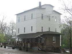
| 22 |
Mansfield Roller Mill |
|
000000001990-12-07-0000December 7, 1990
(#90001788) |
Mansfield Rd. at Big Raccoon Creek at Mansfield
39°40′37″N 87°06′06″W / 39.676944°N 87.101667°W / 39.676944; -87.101667 (Mansfield Roller Mill) |
Jackson Township |
|
| 23 |
Marshall Bridge |
|
000000001978-12-22-0000December 22, 1978
(#78000400) |
North of Rockville
39°53′00″N 87°19′35″W / 39.883333°N 87.326389°W / 39.883333; -87.326389 (Marshall Bridge) |
Liberty Township |
|
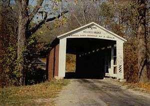
| 24 |
McAllister Bridge |
|
000000001978-12-22-0000December 22, 1978
(#78000398) |
North of Bridgeton
39°42′34″N 87°11′30″W / 39.709444°N 87.191667°W / 39.709444; -87.191667 (McAllister Bridge) |
Adams Township |
|
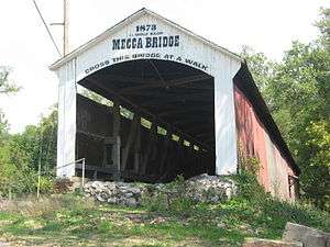
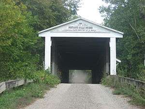
| 25 |
Mecca Bridge |
|
000000001978-12-22-0000December 22, 1978
(#78000401) |
Off U.S. Route 41
39°43′45″N 87°19′29″W / 39.729167°N 87.324722°W / 39.729167; -87.324722 (Mecca Bridge) |
Mecca |
|
| 26 |
Melcher Bridge |
|
000000001978-12-22-0000December 22, 1978
(#78000402) |
East of Montezuma
39°47′20″N 87°20′06″W / 39.788889°N 87.335°W / 39.788889; -87.335 (Melcher Bridge) |
Reserve Township |
|
| 27 |
Mill Creek Bridge |
|
000000001978-12-22-0000December 22, 1978
(#78000403) |
North of Rockville
39°54′30″N 87°21′38″W / 39.908333°N 87.360556°W / 39.908333; -87.360556 (Mill Creek Bridge) |
Liberty Township |
|
| 28 |
Narrows Bridge |
|
000000001978-12-22-0000December 22, 1978
(#78000404) |
North of Rockville off State Road 47
39°53′28″N 87°11′07″W / 39.891111°N 87.185278°W / 39.891111; -87.185278 (Narrows Bridge) |
Sugar Creek Township |
|
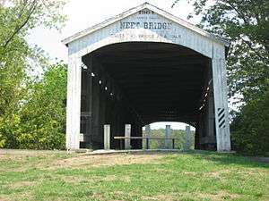
| 29 |
Neet Bridge |
|
000000001978-12-22-0000December 22, 1978
(#78000405) |
North of Bridgeton
39°42′06″N 87°11′52″W / 39.701667°N 87.197778°W / 39.701667; -87.197778 (Neet Bridge) |
Adams Township |
|
| 30 |
Nevins Bridge |
|
000000001978-12-22-0000December 22, 1978
(#78000406) |
Northwest of Bridgeton
39°41′04″N 87°12′45″W / 39.684444°N 87.2125°W / 39.684444; -87.2125 (Nevins Bridge) |
Raccoon Township |
|
| 31 |
Phillips Bridge |
|
000000001978-12-22-0000December 22, 1978
(#78000407) |
Southeast of Montezuma off U.S. Route 36
39°46′20″N 87°19′21″W / 39.772222°N 87.3225°W / 39.772222; -87.3225 (Phillips Bridge) |
Wabash Township |
|
| 32 |
Portland Mills Bridge |
|
000000001978-12-22-0000December 22, 1978
(#78000408) |
East of Marshall off State Road 47
39°51′39″N 87°05′20″W / 39.860750°N 87.088889°W / 39.860750; -87.088889 (Portland Mills Bridge) |
Greene Townshuip |
Oldest covered bridge in Parke County
|
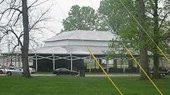
| 33 |
Rockville Chautauqua Pavilion |
|
000000001999-03-12-0000March 12, 1999
(#99000301) |
College St. and Mecca Rd.
39°45′35″N 87°14′06″W / 39.759722°N 87.235°W / 39.759722; -87.235 (Rockville Chautauqua Pavilion) |
Rockville |
|
| 34 |
Rockville Historic District |
|
000000001993-05-27-0000May 27, 1993
(#93000471) |
Roughly bounded by Howard Ave. and Jefferson, High, and College Sts.
39°45′47″N 87°13′51″W / 39.763056°N 87.230833°W / 39.763056; -87.230833 (Rockville Historic District) |
Rockville |
|
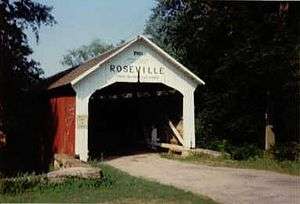
| 35 |
Roseville Bridge |
|
000000001978-12-22-0000December 22, 1978
(#78000409) |
Southeast of Mecca off Old Greencastle Rd.
39°39′09″N 87°17′37″W / 39.6525°N 87.293611°W / 39.6525; -87.293611 (Roseville Bridge) |
Florida Township |
|
| 36 |
Rush Creek Bridge |
|
000000001978-12-22-0000December 22, 1978
(#78000410) |
North of Rockville
39°53′56″N 87°18′53″W / 39.898889°N 87.314722°W / 39.898889; -87.314722 (Rush Creek Bridge) |
Liberty Township |
|
| 37 |
Sim Smith Bridge |
|
000000001978-12-22-0000December 22, 1978
(#78000411) |
Southeast of Montezuma off U.S. Route 36
39°46′24″N 87°19′52″W / 39.773333°N 87.331111°W / 39.773333; -87.331111 (Sim Smith Bridge) |
Wabash Township |
|
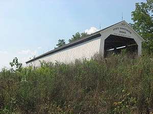
| 38 |
State Sanitorium Bridge |
|
000000001978-12-22-0000December 22, 1978
(#78000412) |
East of Rockville off U.S. Route 36
39°46′52″N 87°08′42″W / 39.781111°N 87.145000°W / 39.781111; -87.145000 (State Sanitorium Bridge) |
Adams and Washington Townships |
|
| 39 |
Thorpe Ford Bridge |
|
000000001978-12-22-0000December 22, 1978
(#78000413) |
Southeast of Mecca on Rosedale Catlin Rd.
39°38′13″N 87°15′59″W / 39.636944°N 87.266389°W / 39.636944; -87.266389 (Thorpe Ford Bridge) |
Florida Township |
|
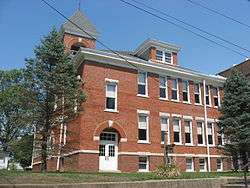
| 40 |
Wabash Township Graded School |
|
000000001987-06-22-0000June 22, 1987
(#87000950) |
S. Montezuma St.
39°43′30″N 87°19′54″W / 39.725000°N 87.331667°W / 39.725000; -87.331667 (Wabash Township Graded School) |
Mecca |
|
| 41 |
West Union Bridge |
|
000000001978-12-22-0000December 22, 1978
(#78000414) |
North of Montezuma
39°51′18″N 87°20′09″W / 39.855°N 87.335833°W / 39.855; -87.335833 (West Union Bridge) |
Union Township |
|
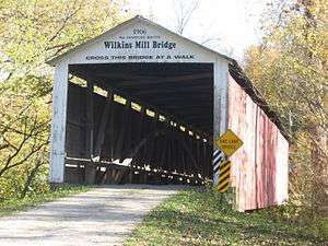
| 42 |
Wilkins Mill Bridge |
|
000000001978-12-22-0000December 22, 1978
(#78000415) |
North of Rockville off U.S. Route 41
39°53′54″N 87°13′59″W / 39.898333°N 87.233056°W / 39.898333; -87.233056 (Wilkins Mill Bridge) |
Sugar Creek Township |
|
| 43 |
W.H. York Round Barn |
|
000000001993-09-16-0000September 16, 1993
(#93000949) |
County Road 249, 0.5 miles southeast of Lodi
39°56′39″N 87°23′44″W / 39.944167°N 87.395556°W / 39.944167; -87.395556 (W.H. York Round Barn) |
Liberty |
|
| 44 |
Zacke Cox Bridge |
|
000000001978-12-22-0000December 22, 1978
(#78000416) |
Southeast of Mecca off U.S. Route 41
39°41′43″N 87°17′09″W / 39.695278°N 87.285833°W / 39.695278; -87.285833 (Zacke Cox Bridge) |
Florida Township |
|

_S_side.JPG)


.jpg)