Gatton, Queensland
| Gatton Queensland | |||||||||||||
|---|---|---|---|---|---|---|---|---|---|---|---|---|---|
 A Landsat montage of Gatton township | |||||||||||||
 Gatton | |||||||||||||
| Coordinates | 27°33′32″S 152°16′34″E / 27.55889°S 152.27611°ECoordinates: 27°33′32″S 152°16′34″E / 27.55889°S 152.27611°E | ||||||||||||
| Population | 6,869 (2011 census)[1] | ||||||||||||
| Established | 1855 | ||||||||||||
| Postcode(s) | 4343 | ||||||||||||
| Elevation | 94 m (308 ft)[2] | ||||||||||||
| Time zone | AEST (UTC+10) | ||||||||||||
| Location | |||||||||||||
| LGA(s) | Lockyer Valley Region | ||||||||||||
| County | Churchill | ||||||||||||
| Parish | Gatton | ||||||||||||
| State electorate(s) | Electoral district of Lockyer | ||||||||||||
| Federal Division(s) | Division of Wright | ||||||||||||
| |||||||||||||
| |||||||||||||
Gatton is a town and the administrative centre of the Lockyer Valley local government area situated in the Lockyer Valley of South East Queensland, Australia. At the 2006 census, Gatton had a population of 6,869.[1]
Over recent years, the rural tranquility of the Gatton area has started to be encroached on by the suburban sprawl of metropolitan Brisbane and Ipswich in the east and Toowoomba in the west. The Warrego Highway, which runs east-west through the Shire, has also experienced increasing strip development, with fuel outlets and commercial properties gradually spreading along the highway.
History

The Gatton area was explored by Major Edmund Lockyer in 1825. A settlement known as Gatton was gazetted in 1855.[3] The post office opened 1 January 1866, with Frederick Lloyd, a dairyman, as the first postmaster.[4] The small village did not experience significant growth until the mid-1870s, after the railway to Grandchester attracted people to the area.[5]
The Queensland Agricultural College opened an agricultural college and experimental farm in 1897 at Gatton.[6]
In December 1898 three local youths from nearby Blackfellow’s Creek were murdered. The crime, known as the Gatton murders, has never been solved.[7]
The Star is a free, local, community newspaper which began publishing in 1956.[8]
Heritage listings
Gatton has a number of heritage-listed sites, including:
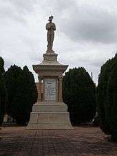
- Crescent Street: Boer War Memorial[9]
- Hickey Street: Weeping Mother Memorial[10]
- Warrego Highway: University of Queensland Gatton Campus[11]
Industry

As part of the "Salad Bowl" of the Lockyer Valley, the area is primarily agricultural, with vegetables making up the majority of crops. Fruit was grown extensively in the area until the 1990s, when economic conditions changed and many of the orchards were removed. There is also significant beef and dairy cattle farming, (Stanbroke Beef operates its abattoir at nearby Grantham) along with a growing equine industry, and the town is also a noted producer of fodder crops, particularly prime lucerne hay.
Gatton Bus Services
Edna Linning and her husband started up Gatton Bus Services in 1957 when they heard a high school was being built in town. Originally, the business only had one bus travelling to the college and back; as of the mid 1980s, the business had 14 buses, eight of which were used for school children. The buses travelled to Flagstone Creek, Buaraba, Esk, and Forest Hill to get students. The company also organized tours of Gatton for schoolchildren that lived in the city, so they could understand farm life and see how produce is grown and harvested. In its early days it also ran tours to Brisbane.
Education
The University of Queensland has a campus on the former Queensland Agricultural College site at Lawes, just to the east of the town of Gatton. This campus is now the base for much of the university's rural focused research and teaching.[12]
Memorials
The town has a number of war memorials:
- The Boer War Memorial was dedicated on 3 August 1908.[13]
- The Weeping Mother Memorial is an unusual depiction of the role of women in war. The foundation stone was laid on 22 April 1922 by the Australian Attorney-General, Littleton Groom and was unveiled on 14 November 1922 by Queensland Governor, Matthew Nathan.[14][15]
- The Gatton Shire War Memorial Pool was dedicated on 1 December 1959 to commemorate those who served in war.[16]
- The National Servicemen's Memorial was erected in November 1996 and commemorates those that served during the national service period of 1951 to 1972.[17]
- The Gatton Agricultural College War Memorial was dedicated on 25 April 1997 to commemorate the staff and students who died in war during the college's first century.[18]
- The Lone Pine Memorial is a tree planted from seeds whose lineage can be traced back to the Lone Pine at Gallipoli. It was dedicated on 19 May 2005.[19] Another Lone Pine Memorial at Gatton Campus also traces its lineage back to Gallipoli.[20]
The Lights on the Hill Truck and Coach Drivers' Memorial is located at Lake Apex Park on the outskirts of Gatton.[21]
See also
References
- 1 2 Australian Bureau of Statistics (31 October 2012). "Gatton (State Suburb)". 2011 Census QuickStats. Retrieved 4 July 2013.
- ↑ "University of Queensland Gatton". Climate Averages for Australian Sites. Bureau of Meteorology. Retrieved 27 November 2009.
- ↑ "Historical Towns Directory". Australian Heritage. Retrieved 4 January 2008.
- ↑ Frew, Joan (1981). Queensland Post Offices 1842–1980 and Receiving Offices 1869–1927, p. 277. Fortitude Valley, Queensland: published by the author, ISBN 0-9593973-0-2
- ↑ Queensland Environmental Protection Agency (2000). Heritage Trails of the Great South East. State of Queensland. p. 62. ISBN 0-7345-1008-X.
- ↑ "Gatton". Lockyer Valley Visitor Information Centre. Retrieved 4 July 2013.
- ↑ Whiticker, Alan J. (2005). Twelve Crimes That Shocked the Nation. ISBN 1-74110-110-7
- ↑ "About Us". Gatton Star. Retrieved 4 July 2013.
- ↑ "Boer War Memorial (entry 600510)". Queensland Heritage Register. Queensland Heritage Council. Retrieved 10 July 2013.
- ↑ "Weeping Mother Memorial (entry 600511)". Queensland Heritage Register. Queensland Heritage Council. Retrieved 10 July 2013.
- ↑ "University of Queensland Gatton Campus (Queensland University) (entry 601672)". Queensland Heritage Register. Queensland Heritage Council. Retrieved 10 July 2013.
- ↑ "About UQ Gatton". The University of Queensland. Retrieved 4 July 2013.
- ↑ "Boer War Memorial". Monument Australia. Retrieved 5 April 2014.
- ↑ Gibson, Lisanne; Joanna Besley (2004). Monumental Queensland: Signposts On A Cultural Landscape. University of Queensland Press. p. 102. ISBN 0702234656. Retrieved 4 July 2013.
- ↑ "Weeping Mother Memorial". Monument Australia. Retrieved 5 April 2014.
- ↑ "http://monumentaustralia.org.au/search/display/91442-gatton-shire-war-memorial-pool". Monument Australia. Retrieved 5 April 2014. External link in
|title=(help) - ↑ "National Servicemen's Memorial". Monument Australia. Retrieved 5 April 2014.
- ↑ "Gatton Agricultural College War Memorial". Monument Australia. Retrieved 5 April 2014.
- ↑ "Lone Pine Memorial". Monument Australia. Retrieved 5 April 2014.
- ↑ "Lone Pine Memorial- Gatton Campus". Monument Australia. Retrieved 5 April 2014.
- ↑ "Lights on the Hill Monument". Monument Australia. Retrieved 5 April 2014.
External links
| Wikimedia Commons has media related to Gatton, Queensland. |
- University of Queensland: Queensland Places: Gatton
- Lights on the Hill Truck & Coach Drivers' Memorial official website