Violet, Louisiana
| Violet | |
| Census-designated place | |
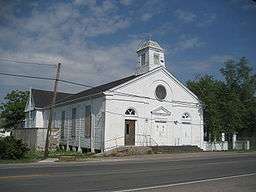 Old Our Lady of Lourdes Church Building, Violet | |
| Country | United States |
|---|---|
| State | Louisiana |
| Parish | St. Bernard |
| Elevation | 3 ft (0.9 m) |
| Coordinates | 29°54′04″N 89°53′49″W / 29.90111°N 89.89694°WCoordinates: 29°54′04″N 89°53′49″W / 29.90111°N 89.89694°W |
| Area | 4.5 sq mi (11.7 km2) |
| - land | 4.1 sq mi (11 km2) |
| - water | 0.5 sq mi (1 km2), 11.11% |
| Population | 8,555 (2000) |
| Density | 2,108.4/sq mi (814.1/km2) |
| Timezone | CST (UTC-6) |
| - summer (DST) | CDT (UTC-5) |
| Area code | 504 |
 Location in St. Bernard Parish and the state of Louisiana. | |
 Location of Louisiana in the United States | |
Violet is a census-designated place (CDP) in St. Bernard Parish, Louisiana, United States. The population was 8,555 at the 2000 census. Violet is located on the east bank of the Mississippi River, about 7.5 miles (12.1 km) southeast of New Orleans and is part of the New Orleans–Metairie–Kenner Metropolitan Statistical Area.
History
The area now known as Violet was originally part of the Livaudais Plantation. Violet sprang up after the development of the Violet Canal. It was named by canal booster Albert Covington Janin, after his wife Violet Blair Janin, a Washington, D.C. socialite and part of the influential Blair family for whom the Blair House across from the White House in Washington D.C. is named.[1] Albert Janin spent his youth in St. Bernard Parish in the large Janin family home. His father, Louis Janin, Sr., a prominent lawyer who had immigrated from France to New Orleans in 1828, sent his sons to Europe for their education, including Albert. Albert was a partner with his father's law firm, including the office in Washington, D. C., where he remained after marrying into the Blair family. His and Violet's life together is told in Virginia Jean Laas's book, Love and Power in the Nineteenth Century, the Marriage of Violet Blair.
Hurricane Katrina
On August 29, 2005, the community was devastated by storm surge and wind associated with Hurricane Katrina which topped the Hurricane Protection Levee and destroyed the Mississippi River-Gulf Outlet Canal (MRGO) levee.
Camp Hope housed volunteers assisting residents of St. Bernard Parish in their recovery from Hurricane Katrina. It was located at the W. Smith Elementary School, 6701 E. St. Bernard Highway.
Geography
Violet is located at 29°54′4″N 89°53′49″W / 29.90111°N 89.89694°W (29.901244, -89.896860).[2]
According to the United States Census Bureau, the CDP has a total area of 4.5 square miles (11.8 km²), of which, 4.1 square miles (10.5 km²) of it is land and 0.5 square miles (1.2 km²) of it (10.57%) is water.
Demographics
As of the census[3] of 2000, there were 8,555 people, 2,744 households, and 2,266 families residing in the CDP. The population density was 2,108.4 people per square mile (813.6/km²). There were 2,918 housing units at an average density of 719.1 per square mile (277.5/km²). The racial makeup of the CDP was 58.29% White, 38.77% African American, 0.48% Native American, 0.58% Asian, 0.01% Pacific Islander, 0.37% from other races, and 1.48% from two or more races. Hispanic or Latino of any race were 4.29% of the population.
There were 2,744 households out of which 45.5% had children under the age of 18 living with them, 54.7% were married couples living together, 21.9% had a female householder with no husband present, and 17.4% were non-families. 14.8% of all households were made up of individuals and 4.2% had someone living alone who was 65 years of age or older. The average household size was 3.10 and the average family size was 3.41.
In the CDP the population was spread out with 32.4% under the age of 18, 9.5% from 18 to 24, 31.5% from 25 to 44, 19.8% from 45 to 64, and 6.8% who were 65 years of age or older. The median age was 31 years. For every 100 females there were 93.3 males. For every 100 females age 18 and over, there were 90.2 males.
The median income for a household in the CDP was $32,993, and the median income for a family was $36,616. Males had a median income of $32,012 versus $24,799 for females. The per capita income for the CDP was $13,894. About 18.5% of families and 21.7% of the population were below the poverty line, including 29.7% of those under age 18 and 26.6% of those age 65 or over.
Notable people
- Elmer R. Tapper, former member of the Louisiana House of Representatives
References
- ↑ Cannizaro, Steve (April 17, 2005). "The name game; Local communities steeped in history, lore". Times-Picayune/St. Bernard Picayune. p. 24.
- ↑ "US Gazetteer files: 2010, 2000, and 1990". United States Census Bureau. 2011-02-12. Retrieved 2011-04-23.
- ↑ "American FactFinder". United States Census Bureau. Retrieved 2008-01-31.
External links
| Wikimedia Commons has media related to Violet, Louisiana. |
Municipalities and communities of St. Bernard Parish, Louisiana, United States | ||
|---|---|---|
| CDPs | 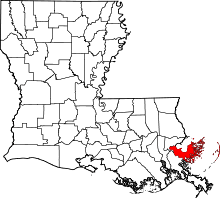 | |
| Unincorporated communities |
| |
| Ghost towns | ||