Florida Parishes
| Florida Parishes | |
|---|---|
 |
The Florida Parishes (Spanish: Parroquias de Florida, French: Paroisses de Floride), the eastern side of Mississippi River which is also known as the Northshore region or the Northlake region, are eight parishes in the southeastern part of the U.S. state of Louisiana, which were part of West Florida in the 18th and early 19th centuries. Unlike most of Louisiana, this region was not part of the 1803 Louisiana Purchase, as it had been under British and then Spanish control for the prior forty years. The parishes are East Baton Rouge, East Feliciana, Livingston, St. Helena, St. Tammany, Tangipahoa, Washington, and West Feliciana.
The United States annexed most of West Florida in 1810. It quickly incorporated the area that became the Florida Parishes into the Territory of Orleans, which became the U.S. state of Louisiana in 1812.
In 1990, the state of Louisiana formally designated the region "the Republic of West Florida Historic Region, or the Florida Parishes."[1]
History

The area that became the Florida Parishes was at one time part of French Louisiana. Following the French and Indian War, however, the region, like most of the rest of French Louisiana east of the Mississippi River (excepting New Orleans), was transferred to Great Britain. The region became part of the British colonial province of West Florida.
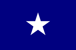
Following the American Revolutionary War, West Florida was the subject of a border dispute between the newly formed United States and Spain, which acquired West and East Florida from the British after the war. The dispute led American and British settlers in the part of West Florida west of the Perdido River to declare an independent Republic of West Florida in 1810 and elected their leader, Fulwar Skipwith, as president. The Republic was quickly annexed by the United States, and the present-day Florida Parishes were incorporated into the Territory of Orleans, which joined the Union as the State of Louisiana in 1812. The flag of the Republic of West Florida, which is often identified with the Bonnie Blue Flag of the Civil War era, flies on many public buildings in the Florida Parishes. In 2006 the state legislature designated it the "official flag of the Republic of West Florida Historic Region."[2]
The Florida Parishes of Louisiana stretch from the Mississippi state line on its eastern and northern borders, to the Mississippi River on its western border, and Lake Pontchartrain on its southern border. The most populated community is the Baton Rouge metropolitan area. St. Tammany Parish is part of the New Orleans metropolitan area.
The Parishes have a land area of 4,685.184 square miles (12,134.57 km²), or 10.755 percent of the state's land area. Its population at the 2000 census was 887,444 residents, or 19.858 percent of the state's population at that time.[3] Its largest communities are, in descending order of population (2000 census), Baton Rouge, Slidell, Hammond, Shenandoah (CDP), Baker, Bogalusa, Zachary, Mandeville, Merrydale (CDP), Gardere (CDP), Denham Springs, Covington, Oak Hills Place (CDP), and Lacombe (CDP).
Interstate 12, which runs east and west through the Northshore region, has been officially designated as the Republic of West Florida Parkway, since 1993.
Parishes
- East Baton Rouge Parish
- East Feliciana Parish
- Livingston Parish
- St. Helena Parish
- St. Tammany Parish
- Tangipahoa Parish
- Washington Parish
- West Feliciana Parish
See also
References
- ↑ "LA Rev Stat § 25:701 Republic of West Florida Historic Region". Justia US Law. Retrieved 2 Aug 2012.
- ↑ "2006 Louisiana Laws - RS 25:705 — Bonnie blue flag adopted". Justia US Law. Retrieved 2 Aug 2012.
- ↑