Unionville, Centre County, Pennsylvania
| Unionville, Centre County, Pennsylvania | |
|---|---|
| Borough | |
|
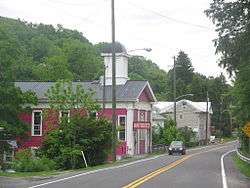
Looking northeast into Unionville along ALT US 220 | |
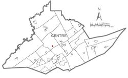 Map showing Unionville in Centre County | |
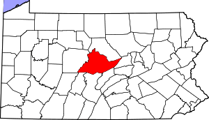 Map showing Centre County in Pennsylvania | |
 Unionville Map showing Unionville in Centre County | |
| Coordinates: 40°54′25″N 77°52′31″W / 40.90694°N 77.87528°WCoordinates: 40°54′25″N 77°52′31″W / 40.90694°N 77.87528°W | |
| Country | United States |
| State | Pennsylvania |
| County | Centre |
| Settled | 1848 |
| Incorporated (borough) | 1859 |
| Area | |
| • Total | 0.3 sq mi (0.7 km2) |
| Elevation | 787 ft (240 m) |
| Population (2010) | |
| • Total | 291 |
| • Density | 1,099.3/sq mi (424.5/km2) |
| Time zone | Eastern (EST) |
| • Summer (DST) | EDT (UTC) |
| Area code(s) | 814 |
Unionville is a borough in Centre County, Pennsylvania, United States. It is part of the State College, Pennsylvania Metropolitan Statistical Area. As of the 2010 census, the borough had a total population of 291.
History
A Late Woodland village, now known as the Fisher Farm Site, is located along Bald Eagle Creek on Unionville's western edge.[1]
In 1979, the Unionville Historic District was listed on the National Register of Historic Places.[2] The district, which includes virtually all of Unionville, was added to the Register for its high quality of preservation since before World War I. Nearly two hundred buildings in the borough qualified as contributing properties. The well known Ridge Soaring Gliderport is located nearby.
Herman Fisher, founder of the Fisher Price toy and game corporation, was born in Unionville.
Geography
Unionville is located at 40°54′25.16″N 77°52′31.80″W / 40.9069889°N 77.8755000°W (40.90698, -77.87550).[3]
According to the United States Census Bureau, the borough has a total area of 0.3 square miles (0.7 km²), all land.
Demographics
| Historical population | |||
|---|---|---|---|
| Census | Pop. | %± | |
| 1870 | 320 | — | |
| 1880 | 399 | 24.7% | |
| 1890 | 348 | −12.8% | |
| 1900 | 360 | 3.4% | |
| 1910 | 343 | −4.7% | |
| 1920 | 311 | −9.3% | |
| 1930 | 304 | −2.3% | |
| 1940 | 321 | 5.6% | |
| 1950 | 341 | 6.2% | |
| 1960 | 371 | 8.8% | |
| 1970 | 375 | 1.1% | |
| 1980 | 361 | −3.7% | |
| 1990 | 284 | −21.3% | |
| 2000 | 313 | 10.2% | |
| 2010 | 291 | −7.0% | |
| Est. 2015 | 282 | [4] | −3.1% |
| Sources:[5][6][7] | |||
As of the census[6] of 2010, there were 291 people, 123 households, and 83 families residing in the borough. The population density was 1,099.3 people per square mile (424.5/km²). There were 130 housing units at an average density of 491.1 per square mile (189.6/km²). The racial makeup of the borough was 97.6% White, 0.3% Black or African American, 0.7% Asian, 0.7% from other races, and 0.7% from two or more races. Hispanic or Latino of any race were 0.7% of the population.
There were 123 households, out of which 26.8% had children under the age of 18 living with them, 53.7% were married couples living together, 2.4% had a male householder with no wife present, 11.4% had a female householder with no husband present, and 32.5% were non-families. 26.8% of all households were made up of individuals, and 10.6% had someone living alone who was 65 years of age or older. The average household size was 2.37 and the average family size was 2.84.
In the borough the population was spread out, with 19.2% under the age of 18, 8.7% from 18 to 24, 26.5% from 25 to 44, 31.2% from 45 to 64, and 14.4% who were 65 years of age or older. The median age was 42 years. For every 100 females there were 87.7 males. For every 100 females age 18 and over, there were 85.0 males.
The median income for a household in the borough was $34,792, and the median income for a family was $31,964. The per capita income for the borough was $21,735. About 21.7% of families and 22.9% of the population were below the poverty line, including 44.4% of those under the age of 18 and 6.7% of those 65 and older.
References
- ↑ Stevenson, Christopher M. and Conran Hay. National Register of Historic Places Inventory/Nomination: Fisher Farm Site. National Park Service, 1980-06-05.
- ↑ National Park Service (2009-03-13). "National Register Information System". National Register of Historic Places. National Park Service.
- ↑ "US Gazetteer files: 2010, 2000, and 1990". United States Census Bureau. 2011-02-12. Retrieved 2011-04-23.
- ↑ "Annual Estimates of the Resident Population for Incorporated Places: April 1, 2010 to July 1, 2015". Retrieved July 2, 2016.
- ↑ "Census of Population and Housing". U.S. Census Bureau. Archived from the original on May 11, 2015. Retrieved 11 December 2013.
- 1 2 "American FactFinder". United States Census Bureau. Archived from the original on September 11, 2013. Retrieved 2008-01-31.
- ↑ "Incorporated Places and Minor Civil Divisions Datasets: Subcounty Resident Population Estimates: April 1, 2010 to July 1, 2012". Population Estimates. U.S. Census Bureau. Archived from the original on June 17, 2013. Retrieved 11 December 2013.