Howard, Pennsylvania
| Howard, Pennsylvania | |
|---|---|
| Borough | |
|
1902 building across from Borough Park | |
 Howard | |
| Coordinates: 41°00′50″N 77°39′17″W / 41.01389°N 77.65472°WCoordinates: 41°00′50″N 77°39′17″W / 41.01389°N 77.65472°W | |
| Country | United States |
| State | Pennsylvania |
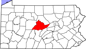
| County | Centre |
| Settled | 1770 |
| Incorporated (borough) | 1864 |
| Area | |
| • Total | 0.3 sq mi (0.9 km2) |
| Elevation | 696 ft (212 m) |
| Population (2010) | |
| • Total | 720 |
| • Density | 2,083.1/sq mi (804.5/km2) |
| Time zone | Eastern (EST) |
| • Summer (DST) | EDT (UTC) |
| Zip code | 16841 |
| Area code(s) | 814 |

Howard is a borough in Centre County, Pennsylvania, United States. It is part of the State College, Pennsylvania Metropolitan Statistical Area. The population was 720 at the 2010 census.
Geography
Howard is located at 41°0′50″N 77°39′17″W / 41.01389°N 77.65472°W (41.013857, -77.654809).[1]
According to the United States Census Bureau, the borough has a total area of 0.3 square miles (0.78 km2), all of it land.
Demographics
| Historical population | |||
|---|---|---|---|
| Census | Pop. | %± | |
| 1870 | 334 | — | |
| 1880 | 498 | 49.1% | |
| 1890 | 554 | 11.2% | |
| 1900 | 563 | 1.6% | |
| 1910 | 667 | 18.5% | |
| 1920 | 621 | −6.9% | |
| 1930 | 664 | 6.9% | |
| 1940 | 726 | 9.3% | |
| 1950 | 754 | 3.9% | |
| 1960 | 770 | 2.1% | |
| 1970 | 751 | −2.5% | |
| 1980 | 838 | 11.6% | |
| 1990 | 749 | −10.6% | |
| 2000 | 699 | −6.7% | |
| 2010 | 720 | 3.0% | |
| Est. 2015 | 722 | [2] | 0.3% |
| Sources:[3][4][5] | |||
As of the census[4] of 2010, there were 720 people, 290 households, and 204 families residing in the borough. The population density was 2,083.1 people per square mile (804.5/km²). There were 311 housing units at an average density of 899.8 per square mile (347.5/km²). The racial makeup of the borough was 97.5% White, 0.4% Black or African American, 0.3% Asian, 0.7% other, and 1.1% of two or more races. Hispanic or Latino of any race were 1.4% of the population.
There were 290 households, out of which 33.1% had children under the age of 18 living with them, 56.2% were married couples living together, 3.4% had a male householder with no wife present, 10.7% had a female householder with no husband present, and 29.7% were non-families. 22.4% of all households were made up of individuals, and 11.0% had someone living alone who was 65 years of age or older. The average household size was 2.48 and the average family size was 2.89.
In the borough the population was spread out, with 23.2% under the age of 18, 6.9% from 18 to 24, 28.4% from 25 to 44, 27.5% from 45 to 64, and 14.0% who were 65 years of age or older. The median age was 40 years. For every 100 females there were 105.1 males. For every 100 females age 18 and over, there were 99.6 males.
The median income for a household in the borough was $51,548, and the median income for a family was $54,107. The per capita income for the borough was $25,304. About 5.9% of families and 8.0% of the population were below the poverty line, including 7.4% of those under age 18 and 13.6% of those age 65 or over.
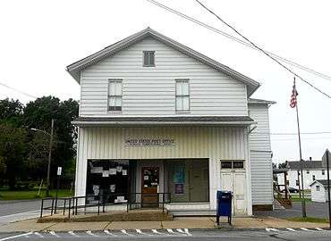 Post office
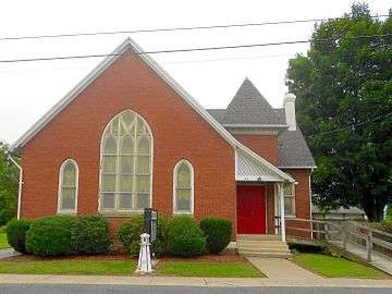 Lighthouse Reformed Church
 Howard Borough Hall across from the Borough Park
References
- ↑ "US Gazetteer files: 2010, 2000, and 1990". United States Census Bureau. 2011-02-12. Retrieved 2011-04-23.
- ↑ "Annual Estimates of the Resident Population for Incorporated Places: April 1, 2010 to July 1, 2015". Retrieved July 2, 2016.
- ↑ "Census of Population and Housing". U.S. Census Bureau. Retrieved 11 December 2013.
- 1 2 "American FactFinder". United States Census Bureau. Retrieved 2008-01-31.
- ↑ "Incorporated Places and Minor Civil Divisions Datasets: Subcounty Resident Population Estimates: April 1, 2010 to July 1, 2012". Population Estimates. U.S. Census Bureau. Retrieved 11 December 2013.