Ridge Soaring Gliderport
| Ridge Soaring Gliderport | |||||||||||
|---|---|---|---|---|---|---|---|---|---|---|---|
 | |||||||||||
| IATA: none – ICAO: none – FAA LID: 79N | |||||||||||
| Summary | |||||||||||
| Airport type | Public | ||||||||||
| Owner | Knauff & Grove, Inc | ||||||||||
| Serves | Unionville, Centre County, Pennsylvania | ||||||||||
| Location | Julian, Pennsylvania | ||||||||||
| Elevation AMSL | 815 ft / 248 m | ||||||||||
| Coordinates | 40°53′02″N 077°54′26″W / 40.88389°N 77.90722°W | ||||||||||
| Runways | |||||||||||
| |||||||||||
| Statistics (2006) | |||||||||||
| |||||||||||

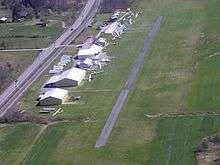
Ridge Soaring Gliderport (FAA LID: 79N) is a public-use glider airport located two nautical miles (4 km) southwest of the central business district of Unionville, in Centre County, Pennsylvania, United States. It is privately owned by Knauff & Grove, Inc.[1]
This FBO airport is world-famous for ridge, thermal and wave soaring. It is located on U.S. Route 220 (alternate) 8 miles south of Interstate 80, between Unionville and Julian, at the base of the Bald Eagle Mountain ridge. It is approximately 10 miles from State College and approximately midway between Altoona and Lock Haven in the Bald Eagle Valley. Visitors can look at an entire wall of U.S. National and World records that have been set from this airfield.
Facilities and aircraft
Ridge Soaring Gliderport covers an area of 90 acres (36 ha) at an elevation of 815 feet (248 m) above mean sea level. It has one runway designated 7/25 with a 3,322 x 150 ft (1,013 x 46 m) asphalt and turf surface.[1]
For the 12-month period ending June 30, 2006, the airport had 18,000 general aviation aircraft operations, an average of 49 per day. At that time there were 34 aircraft based at this airport: 88% glider and 12% single-engine.[1]
At the airport there is a bunkhouse with showers, small kitchen, pilots lounge, motorhome facilities, aircraft hangars and protected storage for glider trailers.
A repair shop with an A&P mechanic and inspector is also on the field.
Airport facts
- Portions of the 1999 movie The Thomas Crown Affair were filmed here.
- Co-owner Thomas L. Knauff set five FAI world records, and over 50 NAA national records flying from this airport.
- Co-owner Doris Grove set three FAI feminine world records flying from this airport, and was the first woman to fly a glider more than 1000 km.
References
External links
- Official web site
- Centre Daily Times, Jun. 28, 2006, A different kind of bird, feature article
- A New Pilot’s Primer To Flying At ‘‘The Ridge'’
- Resources for this airport:
- FAA airport information for 79N
- AirNav airport information for 79N
- FlightAware airport information and live flight tracker
- SkyVector aeronautical chart for 79N