U.S. Route 19 in North Carolina
| ||||
|---|---|---|---|---|
|
Route of US 19 in North Carolina highlighted in red | ||||
| Route information | ||||
| Maintained by NCDOT | ||||
| Length: | 145.0 mi[1] (233.4 km) | |||
| Existed: | 1927 – present | |||
| Tourist routes: |
| |||
| Major junctions | ||||
| South end: |
| |||
|
| ||||
| North end: |
| |||
| Location | ||||
| Counties: | Cherokee, Graham, Swain, Jackson, Haywood, Buncombe, Madison, Yancey | |||
| Highway system | ||||
| ||||

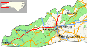
U.S. Route 19 (US 19) traverses 145 miles (233 km) across Western North Carolina; from the Georgia state line, at the community of Bellview, to Cane River, where US 19 splits into US 19E and US 19W, which take separate routes into Tennessee
Route description

US 19 begins at the Georgia state line overlapped with US 129; 4 miles (6.4 km) into North Carolina, it joins with US 64/US 74 in Ranger. From Ranger to Andrews, the highway is a four-lane expressway that bypasses all the towns and communities along its route. After Andrews, US 19 reverts to two-lane through the Nantahala Gorge, which both scenic and somewhat curvy 21 miles (34 km) drive till Almond.
At the start of the Great Smoky Mountains Expressway, US 19 exits off towards the towns of Bryson City and Cherokee. At Cherokee, travelers may go north on US 441 to the Great Smoky Mountains National Park or to the Blue Ridge Parkway before traveling through the rest of the Qualla Boundary.
The highway expands back into a four-lane expressway in Maggie Valley, where it then merges with the Great Smoky Mountains Expressway for 3 miles (4.8 km) before exiting back off towards Clyde. From here, US 19 parallels with I-40 to Asheville. US 19 joins other highways in Asheville crossing over the French Broad River, then follows I-26 to Mars Hill, North Carolina. At exit 9, US 19 splits from I-26/US 23; after 10 miles (16 km), US 19 splits into US 19E and US 19W at Cane River. US 19 travels a total of 145 miles (233 km) from the Georgia state line to Cane River.[1]
US 19 also make up part of Corridor A, Corridor B and Corridor K in the Appalachian Development Highway System (ADHS). Corridor A connects I-285, in Sandy Springs, Georgia, to I-40, near Clyde, North Carolina, it overlaps 2.5 miles (4.0 km) of US 19. Corridor B connects I-40, in Asheville, North Carolina, with US 23, near Lucasville, Ohio, it overlaps 19 miles (31 km) of US 19. Corridor K connects I-75, in Cleveland, Tennessee, with US 23, in Dillsboro, North Carolina, overlapping 49 miles (79 km) of US 19. ADHS provides additional funds, as authorized by the U.S. Congress, which have enabled US 19 to benefit from the successive improvements along its routing through each corridor. The white-on-blue banner "Appalachian Highway" is used to mark the ADHS corridor.[2]
Dedicated and memorial names
US 19 in North Carolina has three dedicated or memorialized sections of highway.
- Great Smoky Mountains Expressway - official name of US 19, on sections that overlap with US 74 in Haywood County. (approved on September 16, 1983).[3]
- Liston B. Ramsey Freeway - official name of US 19, on the section that overlaps with I-26 in Madison.[3]
- Morris L. McGough Freeway – official name of I-26/US 19/US 23 from I-240 to the Buncombe/Madison county line (approved on April 4, 2002).[3]
Scenic byways
US 19 is part of two scenic byways in the state (indicated by a Scenic Byways sign).[4]
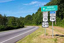
Nantahala Byway is an 43-mile (69 km) byway from Marble to Whittier; it traverses along the Nantahala River and Tuckasegee River. US 19 overlaps almost the entire route, except south and east of Bryson City. This byway also connects to the Indian Lakes Scenic Byway (at Topton and Almond via US 129 and NC 28).[4]
Mount Mitchell Scenic Drive is an 52-mile (84 km) byway from Interstate 26, through Burnsville, to the summit of Mount Mitchell State Park. It is known for its vistas in and around the Black Mountains. US 19 overlaps from Interstate 26 to Micaville.[4]
History
Established in 1927, US 19 traversed from the Georgia state line (at Bellview) to the Tennessee state line (at Elk Park), roughly similar to the route seen today. In 1930, US 19 was truncated at Cane River, where it was split into US 19E and US 19W; US 19E follows the original US 19 routing north. In 1932, it was rerouted in Asheville from Haywood Road to Clingman Avenue, to Hilliard Avenue to Biltmore AVenue towards Broadway Street. In 1937, US 19 was rerouted south of Almond to its current alignment today; while it was rerouted through downtown Asheville again: from Haywood Road to Clingman Avenue to Patton Avenue to College Avenue to Biltmore Avenue towards Broadway Street.[5]
In the 1940s, additional construction work on US 19 was assured by a compromise made with the Eastern Band of Cherokee Indians in return for right-of-way through the Qualla Boundary for the Blue Ridge Parkway.
In 1947, US 19 was rerouted from Ela, traversing through Dillsboro, Sylva, and Waynesville, to Lake Junaluska. The old route, through Cherokee and Maggie Valley became US 19A. In 1948, it was switched, having US 19 back along the original route and US 19A going south to Lake Junaluska.[5]
In 1949, US 19 was moved onto the Smokey Park Highway/Patton Avenue as a bypass in West Asheville. The old alignment became US 19A (today's US 19 Business). In 1952, US 19 was rerouted off Martins Creek Road and onto Blairsville Highway, near Ranger. In 1954, US 19 was realigned to its current route from Lake Junaluska to Clyde and Canton; .5 miles (0.80 km) of the old route was replaced by NC 209. Between 1955-57, US 19 was split onto one-way streets in downtown Asheville: Northbound used Patton, to Market, to Woodfin, to Broadway; southbound used Broadway to College, to Patton. In 1961, US 19 removed from downtown Asheville and put on the East-West Expressway, north at Marrimon Avenue. Between 1963-68, US 19 was split onto one-way streets in downtown Canton (Park Street and Main Street). In 1961, US 19 was moved onto new freeway west of Weaverville; the old route became US 19 Business.[5]
In 1973, US 19 was removed from Marrimon Avenue to its current alignment north of Asheville. In 1975, the freeway, US 19 traversed, was extended from Weaverville to Mars Hill. In 1979, US 19 bypassed Andrews, US 19 Business replaced old route. In 1980, US 19 bypassed Murphy, US 19 Business replaced old route. In 1984, US 19 was realigned in Yancey County to its current routing, US 19W was extended .4 miles (0.64 km) south.[5]
On November 2, 2012, US 19/US 19E was widened from I-26 to Jacks Creek Road, just west of Burnsville. At $107.9 million, the 13.6 miles (21.9 km) two-lane mountain road was upgraded to a four-lane highway, and the first for Yancey County. Governor Bev Perdue was on hand at the ribbon cutting ceremony opening the highway.[6][7]
Future
US 19/74, from Andrews to Almond, is to be realigned onto a new multi-lane highway west of the Nantahala Gorge. The project is broken into several sections, all subject to reprioritization.[8]
US 19/23, from Canton to Candler, is to be widened to a multi-lane highway and its bridge replaced over the Pigeon River. This project is currently funded.[9][10]
US 19, in concurrency with Interstate 26 and US 23, is planned to be realigned onto a new interchange at Interstate 240 and freeway improvements north from it. Right-of-way purchases are to begin in 2023, however the project is unfunded.[11][12]
Junction list
| County | Location | mi[1] | km | Exit | Destinations | Notes | |
|---|---|---|---|---|---|---|---|
| Cherokee | Bellview | 0.0 | 0.0 | Georgia state line | |||
| Ranger | 4.0 | 6.4 | West end of US 64/74 overlap | ||||
| Murphy | 9.0 | 14.5 | |||||
| 9.5 | 15.3 | East end of US 64 overlap | |||||
| | 12.0 | 19.3 | |||||
| Marble | 18.0 | 29.0 | |||||
| Andrews | 23.5 | 37.8 | |||||
| 26.5 | 42.6 | ||||||
| Graham | Topton | 33.5 | 53.9 | North end of US 129 overlap | |||
| Swain | Almond | 48.0 | 77.2 | North end of NC 28 overlap; also to Fontana Dam | |||
| Lauada | 51.0 | 82.1 | South end of NC 28 overlap | ||||
| | 53.0 | 85.3 | 64 | East end of US 74 overlap | |||
| Bryson City | 56.3 | 90.6 | |||||
| Cherokee | 66.0 | 106.2 | South end of US 441 overlap | ||||
| 66.5 | 107.0 | North end of US 441 and south end of US 441 Business overlap | |||||
| 67.0 | 107.8 | South end of US 441 Business overlap | |||||
| Haywood | | 78.0 | 125.5 | Blue Ridge Parkway | |||
| Dellwood | 87.0 | 140.0 | North end of US 276 overlap | ||||
| Lake Junaluska | 89.0 | 143.2 | South end of US 276 overlap | ||||
| 90.0 | 144.8 | 103 | South end of US 23 and west end of US 74 overlap, northbound exit and Southbound entrance | ||||
| 91.0 | 146.5 | 104 | |||||
| 92.0 | 148.1 | 105 | West Jones Cove | No southbound entrance | |||
| Clyde | 93.0 | 149.7 | 106 | East end of US 74 overlap | |||
| Canton | 97.0 | 156.1 | North end of NC 215 overlap | ||||
| 98.0 | 157.7 | South end of NC 215 overlap | |||||
| 98.2 | 158.0 | ||||||
| Buncombe | Candler | 107.0 | 172.2 | ||||
| Enka | 109.0 | 175.4 | |||||
| Asheville | 110.0 | 177.0 | West end of US 74A overlap | ||||
| 113.0 | 181.9 | ||||||
| 114.0 | 183.5 | ||||||
| 115.0 | 185.1 | East end of Future I-26 overlap, west end of I-240 overlap; business routes hidden at intersection | |||||
| US 19 overlaps with Interstate 26 (exits 3A to 9). | |||||||
| Madison | | 134.0 | 215.7 | West end of I-26 overlap, north end of US 23 overlap, brief US 23A overlap | |||
| Yancey | Cane River | 145.0 | 233.4 | US 19 ends; US 19E and US 19W begin | |||
1.000 mi = 1.609 km; 1.000 km = 0.621 mi
| |||||||
See also
References
- 1 2 3 Google (2011-01-31). "US 19 in North Carolina" (Map). Google Maps. Google. Retrieved 2011-01-31.
- ↑ "Status of Corridors in North Carolina" (PDF). Appalachian Regional Commission. September 30, 2013. Retrieved October 24, 2014.
- 1 2 3 "North Carolina Memorial Highways and other Named Facilities" (PDF). North Carolina Department of Transportation. Retrieved November 16, 2012.
- 1 2 3 "North Carolina Scenic Byways" (PDF). North Carolina Department of Transportation. Retrieved November 16, 2012.
- 1 2 3 4 "NCRoads.com: US 19". Retrieved October 31, 2010.
- ↑ Barrett, Mark (November 2, 2012). "Wider U.S. 19 opens". Asheville, NC: Asheville Citizen-Times. Retrieved November 16, 2012.
- ↑ Staff. "U.S. 19 Ribbon Cutting". NCDOTcommunications. Retrieved November 16, 2012.
- ↑ Staff. "Project #A-0009". Project Details. North Carolina Department of Transportation. Retrieved November 16, 2012.
- ↑ Staff. "Project #B-3656". Project Details. North Carolina Department of Transportation. Retrieved November 16, 2012.
- ↑ Staff. "Project #R-4406". Project Details. North Carolina Department of Transportation. Retrieved November 16, 2012.
- ↑ Staff. "Project #A-0010". Project Details. North Carolina Department of Transportation. Retrieved November 16, 2012.
- ↑ Staff. "Project #I-2513". Project Details. North Carolina Department of Transportation. Retrieved November 16, 2012.
External links
-
 Media related to U.S. Route 19 in North Carolina at Wikimedia Commons
 - NCRoads.com: US 19
- NCRoads.com: US 19A
- NCRoads.com: US 19E
- NCRoads.com: US 19W
- NCRoads.com: US 19 Business
| Preceded by Georgia |
U.S. Route 19 North Carolina |
Succeeded by 19E - 19W |