Interstate 40 in Tennessee
| ||||
|---|---|---|---|---|
_map.svg.png) | ||||
| Route information | ||||
| Maintained by TDOT | ||||
| Length: | 455.28 mi (732.70 km) | |||
| Major junctions | ||||
| West end: |
| |||
|
| ||||
| East end: |
| |||
| Location | ||||
| Counties: | Shelby, Fayette, Haywood, Madison, Henderson, Carroll, Decatur, Benton, Humphreys, Hickman, Dickson, Williamson, Cheatham, Davidson, Wilson, Smith, Putnam, Cumberland, Roane, Loudon, Knox, Sevier, Jefferson, Cocke | |||
| Highway system | ||||
| ||||
Interstate 40 (I-40) traverses the entirety of the state of Tennessee from west to east, running from the Mississippi River at the Arkansas border to the northern base of the Great Smoky Mountains at the North Carolina border. The road connects Tennessee's three largest cities—Memphis, Nashville, and Knoxville—and crosses all of Tennessee's physiographical provinces and Grand Divisions—the Mississippi Embayment and Gulf Coastal Plain in West Tennessee, the Highland Rim and Nashville Basin in Middle Tennessee, and the Cumberland Plateau, Appalachian Valley and Ridge Province, and Blue Ridge Province in East Tennessee. The Tennessee section of I-40 is 455 miles (732 km) long, the longest of any state.
Route description
West Tennessee
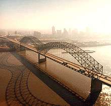
I-40 enters Tennessee from Arkansas via the Hernando de Soto Bridge, which spans the Mississippi River at river mile 736. The Interstate passes across the southern half of Mud Island before crossing the Wolf River Harbor into downtown Memphis. At the I-240 interchange, I-40 abruptly turns north, following the route redesignated due to the Overton Park controversy in the 1970s. I-40 crosses the Wolf River three times in Memphis, as the road passes near the neighborhoods of Frayser and Raleigh and turns back onto the original routing of I-40 (the western continuation of what would have been I-40 at this point is known as Sam Cooper Boulevard).
I-40 leaves the Memphis area, crosses over the Loosahatchie River and Hatchie River, the latter near Brownsville. At mile 78, the road crosses the South Fork of the Forked Deer River into Jackson, and from Jackson proceeds through the northern half of Natchez Trace State Park. At mile 135, I-40 crosses the Tennessee River into Middle Tennessee.
The first 130 miles (210 km) of the Interstate in Tennessee are relatively flat as the road traverses the Gulf Coastal Plain, but there are some gentle to moderately rolling hills, especially as one continues eastward into the higher areas of West Tennessee. Some of the steepest or most rugged sections in West Tennessee are between miles 21–27, around mile 56 (near the Hatchie River crossing), between miles 79–85 around Jackson, around Natchez Trace State Park, and just to the west of the Tennessee River as the road descends about 400 feet (120 m) over the course of a mile.
Middle Tennessee
_in_Nashville.JPG)
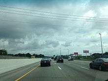
East of the Tennessee River, the rugged hills of the Western Highland Rim flank I-40 for a considerable stretch before the Interstate descends to the Nashville Basin between miles 186 and 188. In Downtown Nashville, I-40 converges with I-24 and I-65, making Nashville one of just four cities in the United States where six interstate legs converge within the city's boundaries. At mile 219, the Interstate crosses the Stones River just downstream from Percy Priest Dam, and continues for roughly 50 miles (80 km) across mostly open farmland.
Between miles 263 and 266, I-40 crosses the meandering Caney Fork five times before ascending the Eastern Highland Rim, reaching 1,000 feet (300 m) for the first time in the state near Silver Point. The Interstate steadies at the edge of the table-top rim at mile 272 (near Baxter) and continues across relatively flat farmland in south Cookeville. Between miles 292 and 297, the Interstate ascends the western escarpment of the Cumberland Plateau, reaching 2,000 feet (610 m) southeast of Monterey. At mile 308, I-40 crosses the Tennessee Divide, where the Cumberland and Tennessee River watersheds meet (in the eastbound lane, the divide is marked by a sign reading "Entering Emory River watershed"; its westbound lane counterpart notes the beginning of the Caney Fork watershed).
East Tennessee

I-40 remains relatively steady as it continues across the Cumberland Plateau and passes through the northern part of Crossville. East of Crossville, the Crab Orchard Mountains (the southern fringe of the Cumberland Mountains) come into view as the road descends several hundred feet. At mile 329, the Interstate enters Crab Orchard Gap and proceeds through a narrow valley once prone to rockslides. At mile 340, the Interstate enters the Eastern Time Zone, and shortly thereafter the road begins its descent of the Cumberland Plateau into the Tennessee Valley. I-40 hugs the slopes of the plateau's Walden Ridge escarpment for several miles— with dramatic views of the Tennessee Valley below to the south— before reaching the base of the plateau at mile 347 between Harriman and Rockwood.

As it enters the Ridge-and-Valley province (of which the Tennessee Valley is a part), I-40 crosses a series of ridges and valleys characteristic of the region's topography. At mile 351, the road crosses the Clinch River, with the Kingston Fossil Plant and its 1,000-foot (300 m) twin smokestacks dominating the view to the north. The road widens to four lanes at mile 368 as I-40 merges with I-75. Knoxville's skyline comes into view at mile 387 before the road passes through downtown Knoxville.
Beyond Knoxville, the Interstate crosses the Holston and French Broad rivers (the French Broad is much wider due to its impoundment by Douglas Dam a few miles downstream) and continues for several miles along the northern base of English Mountain. At mile 440, the road turns south through the gap between English Mountain and Stone Mountain, revealing a dramatic view of the 4,928-foot (1,502 m) Mount Cammerer at the northeastern end of the Great Smokies range, and the road proceeds into the Pigeon River Gorge, closely following the north bank of the river. The massive mesh nets on the cliffslopes are indicative of the rockslide prevention measures along this stretch of I-40.
Music Highway
The term Music Highway refers to a section of I-40 between Memphis and Nashville. I-40 was designated as such by an act of the Tennessee Legislature in 1997 "from the eastern boundary of Davidson County to the Mississippi River in Shelby County," a distance of about 222 miles (357 km). I-40 is designated as such because of the rich music history in Memphis, Nashville, and the areas in between them. Memphis is known as "the Home of the Blues and the Birthplace of Rock and Roll." Nashville is known as "Music City USA" for its influence on numerous types of music, especially country. Several cities and towns between the two, such as Jackson, Brownsville, Nutbush (Near Ripley), Waverly and others were birthplaces or homes of numerous singers and songwriters. Signs that display the words "Music Highway" along with music notes are erected in both directions along I-40, especially at the borders of Shelby County and Davidson County (Nashville).[1]
History
The Tennessee leg of I-40 was part of the original 1,047 miles (1,685 km) of Interstate Highways authorized for Tennessee by the Federal Aid Highway Act of 1956. The first section of Interstate 40—Nonconnah Creek to Hindman Ferry Road in Shelby County (originally I-240)—was contracted in 1956, and within a year contracts had been awarded for sections in Davidson, Knox, Roane, Haywood, Madison, Jefferson, and Cocke counties. By 1958, sections in Loudon, Smith, Putnam, Cumberland, Humphreys, Hickman, and Sevier counties had been contracted. Most of I-40 had been completed by the late 1960s.[2]
In Memphis, I-40 was originally slated to pass through the city's Overton Park, a 342-acre (138 ha) wooded refuge that had become an important stopover for migratory birds. Fearing that the Interstate's construction would upset the park's fragile ecological balance, environmentalists waged a 12-year legal battle to prevent highway construction in the park, culminating in the United States Supreme Court decision, Citizens to Preserve Overton Park v. Volpe. The Supreme Court remanded the case to the District Court for further review, and it ruled that the highway commission had not adequately explored alternative routes. In 1981, the highway commission abandoned plans to route I-40 through Overton Park, and instead redesignated the northern portion of I-240 as I-40.[3] For over 20 years, I-40 signage existed on the dead-end route toward Overton Park. To this day, signs still exist on overhead gantries leading westbound drivers on Sam Cooper "To Little Rock". Several miles of a limited-access road were actually built within the I-240 loop; this portion of highway still exists and is in regular use as Sam Cooper Boulevard, reaching the eastern end of Chickasaw Country Club and the Binghampton neighborhood, and then East Parkway.
SmartFix 40
Until June 12, 2009,[4] a section of I-40 through downtown Knoxville between James White Parkway and Hall of Fame Drive was completely closed to all traffic for about 18 months for reconstruction. Through traffic was required to use I-640 or to use surface streets. The four-lane section, which was quite substandard, congested, and accident-prone, was widened to six lanes to improve traffic flow and safety. Several interchanges along that stretch were also reconstructed.[5]
Geological difficulties
The rugged terrain of East Tennessee presented numerous challenges for I-40 construction crews and engineers. Rockslides, especially along the eastern Cumberland Plateau and in the Pigeon River Gorge, have been a persistent problem since the road's construction.
Crab Orchard
In December 1986, a truck driver was killed when his truck skidded across some rocks that had spilled across the road just east of Crab Orchard (between miles 331 and 333). In response, the Tennessee Department of Transportation (TDOT) flattened the cutslopes along this stretch of Interstate and moved the road 60 feet (18 m) away from the problematic cliffside.[6]
Twenty rockslides occurred along the Walden Ridge section (miles 341–346) of the eastern plateau in 1968 alone, prompting various remedial measures throughout the 1970s, including the employment of rock buttresses, gabion walls, and horizontal drains. A minor rockslide shut down the right lane of westbound I-40 at mile 343 on May 6, 2013.[7]
Pigeon River Gorge
An area very prone to rockslides is the Pigeon River Gorge, especially in the vicinity of the Tennessee–North Carolina state line. Throughout the 1970s, this stretch of I-40 was repeatedly shut down by rockslides, sometimes for several weeks at a time. In the late 1970s and early 1980s, TDOT dug over 24,000 feet (7,300 m) of horizontal drains, blasted out large volumes of unstable rocks, and installed massive mesh catchment fences.[6] Nevertheless, rockslides in 1985 and 1997 again forced the closure of I-40 in the Pigeon River Gorge for several weeks.[8] Additional stabilization measures were implemented, including the blasting of loose rock, the installation of rock bolts, and the construction of a better drainage system.[9] In spite of these measures, another massive rock slide occurred in the Pigeon River Gorge on October 26, 2009, blocking all lanes just across the border at North Carolina mile 3. The section was closed to traffic in both directions until April 25, 2010.[10] On January 31, 2012, the westbound lanes of I-40 were closed because of a rockslide near the North Carolina border. Traffic was detoured along I-26 and I-81 and reopened a few months later.[11]
Sinkholes
Sinkholes are a consistent issue along highways in East Tennessee. One particularly problematic stretch is a section of I-40 between miles 365 and 367 in Loudon County, which is underlain by cavernous rock strata. In the 1970s and 1980s, TDOT employed numerous stabilization measures in this area, including backfilling existing sinkholes with limestone, collapsing potential sinkholes, and paving roadside ditches to prevent surface water from seeping into the volatile soil.[6]
Future
TDOT officially announced the I-40/I-81 Corridor Feasibility Study on July 27, 2007.[12] The intent of this study is to assess deficiencies along I-40 and I-81 in Tennessee and to develop upgrade proposals for the existing corridor.[13] This study was completed in 2008.
On January 18, 2008, the Federal Highway Administration authorized the states of Mississippi and Tennessee to extend I-69 from the I-40/SR 300 interchange in north Memphis to the I-55/I-69 interchange in Hernando, Mississippi; however, Tennessee has not yet signed the extension of the route, although Mississippi has already done so.[14]
Construction is currently taking place to reconfigure the I-40/I-240 interchange in East Memphis. This reconfiguration is needed since the original configuration was designed as if I-40 were to go through the center of the city along what is now Sam Cooper Boulevard. The first phase of the project replaced a one-lane loop ramp from I-40 westbound to I-240 southbound with a two-lane flyover. Portions of both Interstates were also widened slightly. This phase was completed in 2003. The second phase (currently underway) was stalled due to funding and redesign. It includes the installation of the remaining flyover from the north loop of I-40 to I-40 eastbound. This will replace a one-lane ramp with a slow design speed that has been the site of several accidents over the years. Other parts of this phase include widening of I-40 between Sycamore View Road and Covington Pike (requiring the replacement of the Wolf River Bridge with a 14-lane bridge), widening of I-240, addition of through lanes on Sam Cooper Boulevard, and reconfiguration of the Covington Pike interchange. The project will cost $109 million (the highest bid project in TDOT history), began late 2013, and should be completed in 2017. The I-40 flyover and expansion of Sam Cooper Boulevard should be completed in 2015.
Exit list
| County | Location | mi | km | Exit | Destinations | Notes |
|---|---|---|---|---|---|---|
| Mississippi River | Hernando de Soto Bridge | |||||
| Shelby | Memphis | 1 | Riverside Drive, Front Street – Downtown Memphis | Western end of Music Highway designation | ||
| 1A | 2nd Street, 3rd Street (SR 3/SR 14) | Westbound exit and eastbound entrance | ||||
| 1B | Signed as exits 1C (south) and 1D (north) westbound | |||||
| 1E | Western end of I-69 overlap; I-240 exit 31 | |||||
| 1F | Westbound exit and eastbound entrance | |||||
| 2 | Chelsea Avenue, Smith Avenue | |||||
| 2A | Future continuation of I-69 north | |||||
| 3 | Watkins Street | |||||
| 5 | Hollywood Street | |||||
| 6 | Warford Street | |||||
| 8 | Signed as exits 8A (north) and 8B (south) westbound | |||||
| 10 | ||||||
| 12A | ||||||
| 12B | Sam Cooper Boulevard | Sam Cooper Blvd. east exit 10B | ||||
| 12C | Sam Cooper Blvd. east exit 10A | |||||
| 12 | Sycamore View Road | |||||
| Bartlett | 14 | Whitten Road | ||||
| 15 | Appling Road | Signed as exits 15A (south) and 15B (north) eastbound | ||||
| 16 | Signed as exits 16A (south) and 16B (north) westbound | |||||
| 18 | ||||||
| Lakeland | 20 | Canada Road – Lakeland | ||||
| Arlington | 24 | Signed as exits 24A (west) and 24B (east) | ||||
| 25 | ||||||
| Fayette | | 35 | ||||
| | 42 | |||||
| Haywood | | 47 | ||||
| | 52 | |||||
| Brownsville | 56 | |||||
| 60 | ||||||
| | 66 | |||||
| Madison | | 68 | ||||
| | 74 | Lower Brownsville Road | ||||
| | 76 | |||||
| Jackson | 79 | |||||
| 80 | Signed as exits 80A (south) and 80B (north) | |||||
| 82 | Signed as exits 82A (south) and 82B (north) | |||||
| 83 | Campbell Street | |||||
| 85 | Christmasville Road, Dr. F.E. Wright Drive – Jackson | |||||
| 87 | ||||||
| | 93 | |||||
| Henderson | | 101 | ||||
| | 108 | |||||
| Henderson–Carroll county line | | 116 | ||||
| Decatur | | 126 | ||||
| Benton | | 133 | ||||
| Tennessee River | Bridge over the Tennessee River | |||||
| Humphreys | | 137 | Cuba Landing | |||
| | 143 | |||||
| Hickman | | 148 | ||||
| | 152 | |||||
| Dickson | | 163 | ||||
| Dickson | 172 | |||||
| | 176 | I-840 exit 0; half-clover interchange. | ||||
| Williamson | | 182 | ||||
| Cheatham | | 188 | ||||
| Davidson | Nashville | 192 | McCrory Lane – Pegram | |||
| 196 | ||||||
| 199 | ||||||
| 201 | Signed as exits 201A (east) and 201B (west) eastbound | |||||
| 204 | Signed as exits 204A (north) and 204B (south) westbound; SR 155 exit 6 | |||||
| 205 | 51st Avenue, 46th Avenue – West Nashville | |||||
| 206 | ||||||
| 207 | 28th Avenue | Westbound exit and eastbound entrance | ||||
| 207 | Jefferson Street | Eastbound exit and westbound entrance | ||||
| 208 | Western end of I-65 overlap, south exit 84B; signed as exit 208B eastbound | |||||
| 209 | Eastbound exit and westbound entrance | |||||
| 209A | Church Street, Charlotte Avenue | Signed as exit 209 westbound | ||||
| 209B | Signed as exit 209A westbound | |||||
| 209B | Demonbreun Street | Westbound exit and eastbound entrance | ||||
| 210 | Eastern end of I-65 overlap, north exit 82B; signed as exit 210B westbound | |||||
| 210C | ||||||
| 211B | Western end of I-24 overlap, east exit 50B; formerly the point where I-24, I-40, and I-65 met | |||||
| 212 | Hermitage Avenue (US 70, SR 24) | Westbound exit and eastbound entrance | ||||
| 212 | Fesslers Lane | Eastbound exit and westbound entrance | ||||
| 213A | Eastern end of I-24 overlap, west exit 52B | |||||
| 213 | Eastbound exit is via 213A | |||||
| 215 | Signed as exits 215A (south) and 215B (north); SR 155 south exit 27; north no number signed | |||||
| 216A | Eastbound exit and westbound entrance | |||||
| 216B | ||||||
| 216C | ||||||
| 219 | Stewarts Ferry Pike – J. Percy Priest Dam | |||||
| 221A | Eastern end of Music Highway designation | |||||
| 221B | Old Hickory Boulevard | |||||
| Wilson | | 226 | Signed as exits 226A (south), 226B (north) eastbound and 226C (Belinda Parkway / Providence Way | |||
| | 229 | Beckwith Road | Signed as exits 229A (south) and 229B (north) eastbound | |||
| Lebanon | 232 | Signed as exits 232A (south) and 232B (north) eastbound | ||||
| 235 | I-840 exit 76; trumpet interchange. | |||||
| 236 | South Hartmann Drive | |||||
| 238 | ||||||
| 239 | Signed as exits 239A (east) and 239B (west) eastbound | |||||
| | 245 | Linwood Road | ||||
| Smith | | 254 | ||||
| | 258 | |||||
| Putnam | | 268 | ||||
| | 273 | Western end of SR 56 overlap | ||||
| | 276 | Old Baxter Road | ||||
| Baxter | 280 | Eastern end of SR 56 overlap | ||||
| Cookeville | 286 | |||||
| 287 | ||||||
| 288 | ||||||
| 290 | ||||||
| Monterey | 300 | |||||
| 301 | ||||||
| Cumberland | | 311 | Plateau Road | |||
| Crossville | 317 | |||||
| 320 | ||||||
| 322 | ||||||
| | 329 | |||||
| | 338 | Western end of SR 299 overlap | ||||
| Roane | Rockwood | 340 | Eastern end of SR 299 overlap | |||
| Harriman | 347 | |||||
| 350 | ||||||
| Clinch River | Bridge over the Clinch River | |||||
| Kingston | 352 | Western end of SR 58 overlap | ||||
| 355 | Lawnville Road | |||||
| 356 | Eastern end of SR 58 overlap; signed as exits 356A (north) and 356B (south) westbound | |||||
| | 360 | Buttermilk Road | ||||
| | 362 | Industrial Park Road – Roane Regional Business and Technology Park | Opened in 2008.[15] | |||
| Loudon | | 364 | ||||
| | 368 | Western end of I-75 overlap | ||||
| Knox | | 369 | Watt Road | |||
| Farragut | 373 | Campbell Station Road – Farragut | ||||
| Knoxville | 374 | |||||
| 376 | Signed as exits 376A (north) and 376B (east); I-140 west exits 1C-D | |||||
| 378 | Cedar Bluff Road | Signed as exits 378A (south) and 378B (north) westbound | ||||
| 379 | Bridgewater Road, Walker Springs Road | |||||
| 379A | Gallaher View Road | Eastbound exit is via exit 379 | ||||
| 380 | ||||||
| 383 | Westbound slip ramp has entrances and exits to/from Papermill Drive and Weisgarber Road | |||||
| 385 | Eastern end of I-75 overlap | |||||
| 386A | University Avenue, Middlebrook Pike (SR 169) | Westbound exit is part of exit 386B | ||||
| 386B | ||||||
| 387 | ||||||
| 387A | I-275 exit 0 | |||||
| 388 | No westbound exit, US 441 exit 0 | |||||
| 388A | Western end of SR 158 overlap (unsigned) | |||||
| 389 | Eastern end of SR 158 overlap (unsigned) | |||||
| 390 | Cherry Street | |||||
| 392 | Signed as exits 392A (south) and 392B (north) | |||||
| 393 | Western end of US 25W/SR 9 overlap | |||||
| 394 | Eastern end of US 25W/SR 9 overlap | |||||
| Holston River | Bridge over the Holston River | |||||
| Strawberry Plains | 398 | Strawberry Plains Pike – Strawberry Plains | ||||
| Midway | 402 | Midway Road – Seven Islands State Birding Park | ||||
| Sevier | Sevierville–Kodak line | 407 | Western end of SR 66 overlap | |||
| Jefferson | | 412 | Deep Springs Road – Douglas Dam | |||
| Dandridge | 415 | Eastern end of SR 66 overlap | ||||
| 417 | ||||||
| | 421 | I-81 exit 0 | ||||
| | 424 | |||||
| French Broad River | Bridge over the French Broad River | |||||
| Cocke | Newport | 432A | ||||
| 432B | ||||||
| 435 | ||||||
| | 440 | |||||
| | 443 | Foothills Parkway – Gatlinburg, Cosby, Great Smoky Mountains National Park | ||||
| | 447 | Hartford Road – Hartford | ||||
| | 451 | Waterville Road | ||||
| | Continuation into North Carolina | |||||
1.000 mi = 1.609 km; 1.000 km = 0.621 mi
| ||||||
Auxiliary routes
 I-140 spur off I-40/I-75 to Alcoa
 I-240 Memphis Inner Beltway; overlaps with I-69
 I-440 inner bypass around Nashville
 I-640 bypass around Knoxville
 I-840 outer bypass around Nashville. Replaced SR 840
See also
 Tennessee portal
 U.S. Roads portal
References
Footnotes
- ↑ "Public Chapter 124 Senate Bill No. 122". State of Tennessee. Retrieved September 26, 2011.
- ↑ Moore (1994), pp. 108–109.
- ↑ Moore (1994), pp. 112–113.
- ↑ "Interstate 40 Reopens In Knoxville 18 days ahead of schedule".
- ↑ Tennessee Department of Transportation. "SmartFix: I-40/James White Parkway/Hall of Fame Drive". Tennessee Department of Transportation.
- 1 2 3 Moore (1994), pp. 120–131.
- ↑ Jacobs, Don (May 6, 2013). "Rock Slide Closes Land of I-40 in Roane County". Knoxville News Sentinel.
- ↑ "I-40 Closed in Both Directions: Another Rock Slide". Raleigh, NC: WRAL-TV. July 1, 1997. Retrieved October 23, 2009.
- ↑ Goumans, Corry & Wallace, Dwayne (1999). "I-40 Rockslide Causes Mountains of Problems" (PDF). Complete Abstracts of the ISEE Proceedings. 1G: 167. Archived from the original (PDF) on September 2, 2003. Retrieved October 23, 2009.
- ↑ Hickman, Hayes. "Section of I-40 Closed Since Oct. Rockslide Reopens". Knoxville News Sentinel. Retrieved September 19, 2011.
- ↑ "Tennessee Rock Slide Closes I-40 near Asheville". Raleigh, NC: WRAL-TV. Retrieved February 4, 2012.
- ↑ Tennessee Department of Transportation (July 27, 2007). "TDOT Performing Corridor Study Along I-40 and I-81: Study to Identify Improvements for 550-Mile Interstate Corridor" (Press release). Tennessee Department of Transportation. Archived from the original on December 13, 2013.
- ↑ Tennessee Department of Transportation. "I-40/I-81 Corridor Feasibility Study Project". Tennessee Department of Transportation.
- ↑ Capka, J. Richard (January 18, 2008). "I-69 and I-55" (PDF) (Letter). Letter to Paul D. Degges. Federal Highway Administration. Retrieved May 28, 2008.
- ↑ Fowler, Bob (October 9, 2008). "Roane Celebrates Access to Industrial Park via I-40". Knoxville News Sentinel.
Works cited
- Moore, Harry (1994). A Geologic Trip Across Tennessee by Interstate 40. Knoxville: University of Tennessee Press.
External links
 Media related to Interstate 40 in Tennessee at Wikimedia Commons
| Previous state: Arkansas |
Tennessee | Next state: North Carolina |
Roads of Memphis | |||||||||||
|---|---|---|---|---|---|---|---|---|---|---|---|
| Interstate Highways |  | ||||||||||
| U.S. Highways | |||||||||||
| State Highways |
| ||||||||||
| Other Highways | |||||||||||