Burnsville, North Carolina
| Burnsville, North Carolina | |
|---|---|
| Town | |
|
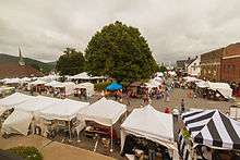
Burnsville Town Square | |
 Location of Burnsville, North Carolina | |
| Coordinates: 35°55′7″N 82°17′51″W / 35.91861°N 82.29750°WCoordinates: 35°55′7″N 82°17′51″W / 35.91861°N 82.29750°W | |
| Country | United States |
| State | North Carolina |
| County | Yancey |
| Area | |
| • Total | 1.6 sq mi (4.1 km2) |
| • Land | 1.6 sq mi (4.1 km2) |
| • Water | 0.0 sq mi (0.0 km2) |
| Elevation | 2,822 ft (860 m) |
| Population (2010) | |
| • Total | 1,693 |
| • Density | 1,028.0/sq mi (396.9/km2) |
| Time zone | Eastern (EST) (UTC-5) |
| • Summer (DST) | EDT (UTC-4) |
| ZIP code | 28714 |
| Area code(s) | 828 |
| FIPS code | 37-09140[1] |
| GNIS feature ID | 1009845[2] |
| Website | http://townofburnsville.org/ |

Burnsville is a town in Yancey County, North Carolina, United States. The population was 1,693 at the 2010 census. It is the county seat of Yancey County.[3]
Geography
Burnsville is located at 35°55′7″N 82°17′51″W / 35.91861°N 82.29750°W (35.918542, -82.297549).[4]
According to the United States Census Bureau, the town has a total area of 1.6 square miles (4.1 km2), all of it land.
Demographics
| Historical population | |||
|---|---|---|---|
| Census | Pop. | %± | |
| 1900 | 207 | — | |
| 1910 | 422 | 103.9% | |
| 1930 | 866 | — | |
| 1940 | 997 | 15.1% | |
| 1950 | 1,341 | 34.5% | |
| 1960 | 1,388 | 3.5% | |
| 1970 | 1,348 | −2.9% | |
| 1980 | 1,452 | 7.7% | |
| 1990 | 1,482 | 2.1% | |
| 2000 | 1,623 | 9.5% | |
| 2010 | 1,693 | 4.3% | |
| Est. 2015 | 1,660 | [5] | −1.9% |
As of the census[1] of 2000, there were 1,623 people, 748 households, and 412 families residing in the town. The population density was 1,028.0 people per square mile (396.6/km²). There were 845 housing units at an average density of 535.2 per square mile (206.5/km²). The racial makeup of the town was 95.50% White, 1.91% African American, 0.49% Native American, 0.43% Asian, 0.86% from other races, and 0.80% from two or more races. Hispanic or Latino of any race were 3.88% of the population.
There were 748 households out of which 21.9% had children under the age of 18 living with them, 41.2% were married couples living together, 11.6% had a female householder with no husband present, and 44.9% were non-families. 42.1% of all households were made up of individuals and 25.1% had someone living alone who was 65 years of age or older. The average household size was 2.00 and the average family size was 2.70.
In the town the population was spread out with 18.1% under the age of 18, 5.7% from 18 to 24, 22.4% from 25 to 44, 23.2% from 45 to 64, and 30.7% who were 65 years of age or older. The median age was 48 years. For every 100 females there were 75.3 males. For every 100 females age 18 and over, there were 70.8 males.
The median income for a household in the town was $21,653, and the median income for a family was $34,712. Males had a median income of $30,227 versus $25,234 for females. The per capita income for the town was $16,894. About 15.3% of families and 19.5% of the population were below the poverty line, including 24.2% of those under age 18 and 19.4% of those age 65 or over.
History
The town was founded on March 6, 1834, from land conveyed by John "Yellow Jacket" Bailey, and named after Captain Otway Burns, a naval hero of the War of 1812. In 1909 a statue of Captain Burns was given to the town by his grandson, Walter Francis Burns, Sr. and was set on a granite pedestal in the center of the town square. It has an inscription which reads, in part, "He Guarded Well Our Seas, Let Our Mountains Honor Him." Due to damages, the original statue was replaced in the early 2000s.
One of the oldest buildings is the Nu-Wray Inn, built in 1833 and listed on the National Register of Historic Places. The Parkway Playhouse, the oldest continually operating summer stock theater company is located in Burnsville, and was started in 1947 by W.R. Taylor (a professor of drama from the Woman's College of North Carolina-now the University of North Carolina-Greensboro) and a group of dedicated community leaders.
In 2016, the Mt. Mitchell Crafts Fair observed its 59th anniversary. This event, which attracts thousands of unique artists and tourists, is held during the first weekend of August that includes a Friday (August 4 & 5 for 2017, 60th anniversary).[7]
On April 6, 2010, the Town of Burnsville, the only incorporated town within Yancey County, held a referendum providing for the legal sale of alcohol within the town limits. The referendum passed, effectively ending prohibition in Yancey County. After applying for and receiving the applicable permits, Burnsville may now operate an ABC store; retail establishments may now sell beer and wine; and restaurants may sell beer, wine, and mixed drinks. Graham County is the last remaining dry county in the state of North Carolina.[8]
In addition to the Nu-Wray Inn, the Bald Creek Historic District, Chase-Coletta House, Citizens Bank Building, John Wesley McElroy House, Yancey Collegiate Institute Historic District, and Yancey County Courthouse are listed on the National Register of Historic Places.[9]
Sights
The Nu-Wray Inn, used as a hotel since its construction in 1833.
The Parkway Playhouse, founded in 1947, as a summer stock theatre, is one of the oldest continually operating theatre companies in North Carolina.
John Wesley McElroy House, built circa 1830s and now in use as a museum.
Mt. Mitchell, the tallest mountain east of the Mississippi River.
Development
In 2006 The North Carolina Department of Transportation began widening US 19 and US 19E from a two-lane highway to a four-lane divided highway. The construction began at the junction of Interstate 26 in Madison County and continues where US 19E intersects with Jacks Creek Road. Construction on this section is complete and was dedicated on November 2, 2012.[10] Work on widening the next section has begun, 7.4 miles from Jacks Creek Road to N.C. 80 in Yancey County; this section was scheduled to be completed by July, 2015,[10] but was extended to May, 2016.[11] Work on this stretch to the Micaville intersection was finally completed and was opened to four-lane pattern over the weekend of October 29-30, 2016.[12]
References
- 1 2 "American FactFinder". United States Census Bureau. Archived from the original on 2013-09-11. Retrieved 2008-01-31.
- ↑ "US Board on Geographic Names". United States Geological Survey. 2007-10-25. Retrieved 2008-01-31.
- ↑ "Find a County". National Association of Counties. Archived from the original on 2011-05-31. Retrieved 2011-06-07.
- ↑ "US Gazetteer files: 2010, 2000, and 1990". United States Census Bureau. 2011-02-12. Retrieved 2011-04-23.
- ↑ "Annual Estimates of the Resident Population for Incorporated Places: April 1, 2010 to July 1, 2015". Retrieved July 2, 2016.
- ↑ "Census of Population and Housing". Census.gov. Archived from the original on May 11, 2015. Retrieved June 4, 2015.
- ↑ "Mt. Mitchell Crafts Fair". Yancey County Chamber of Commerce. Retrieved 2016-11-04.
- ↑ "Burnsville voters approve alcohol sales". Asheville Citizen-Times.com. Retrieved 2014-05-10.
- ↑ National Park Service (2010-07-09). "National Register Information System". National Register of Historic Places. National Park Service.
- 1 2 "Gov. Perdue and Transportation Secretary Conti Join State and Local Officials to Celebrate Completion of First Section of U.S. 19 Widening Project in Madison and Yancey Counties". NC DOT News Release. North Carolina Department of Transportation. Retrieved 2014-05-10.
- ↑ "Young McQueen pushes to complete in roadway work before Yancey Schools reopen this Fall". Yancey Times Journal. 2016-07-15. Retrieved 2016-02-29.
- ↑ "Roadway traffic switches to four lane pattern, finally]". Yancey Times Journal. 2016-10-02. Retrieved 2016-10-04.
External links
- Official website
- Community History
- Yancey County Chamber of Commerce History Page
- Yancey County News - weekly newspaper in Burnsville
Municipalities and communities of Yancey County, North Carolina, United States | ||
|---|---|---|
| Town |  | |
| Unincorporated communities |
| |