Erwin, Tennessee
| Erwin, Tennessee | |
|---|---|
| Town | |
|
View along Main Street in Erwin | |
| Nickname(s): The Valley Beautiful | |
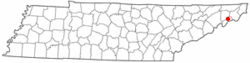 Location of Erwin, Tennessee | |
| Coordinates: 36°8′42″N 82°24′39″W / 36.14500°N 82.41083°WCoordinates: 36°8′42″N 82°24′39″W / 36.14500°N 82.41083°W | |
| Country | United States |
| State | Tennessee |
| County | Unicoi |
| Settled | 1780s[1] |
| Founded | 1876[1] |
| Incorporated | 1903[2] |
| Named for | David J.N. Ervin, early resident[3] |
| Government | |
| • Type | Municipal Corporation |
| • Mayor | Doris Hensley |
| • Aldermen | Lester Bailey Jr., Gary Chandler, Gary Edwards, Robie Sullins Jr., Sue Jean Wilson |
| Area | |
| • Total | 3.6 sq mi (9.2 km2) |
| • Land | 3.5 sq mi (9.2 km2) |
| • Water | 0.0 sq mi (0.0 km2) |
| Elevation | 1,673 ft (510 m) |
| Population (2010)[4] | |
| • Total | 6,097 |
| • Density | 1,582.8/sq mi (611.1/km2) |
| Time zone | Eastern (EST) (UTC-5) |
| • Summer (DST) | EDT (UTC-4) |
| ZIP code | 37650 |
| Area code(s) | 423 |
| FIPS code | 47-24360[5] |
| GNIS feature ID | 1328148[6] |
| Website | erwintn.org |

Erwin is a town in and the county seat of Unicoi County, Tennessee, United States.[7] The population was 6,097 at the 2010 census. It is part of the Johnson City Metropolitan Statistical Area, which is a component of the Johnson City–Kingsport–Bristol, TN-VA Combined Statistical Area – commonly known as the "Tri-Cities" region.
History

The town of Erwin received its name by a mail mishap. On December 5, 1879, the name of the town was Ervin, in honor of D.J.N. Ervin, who had donated 15 acres (61,000 m2) of land for the county seat. A typo made by post office officials caused the name to be recorded as Erwin. The mistake was never corrected.
Erwin earned some notoriety in 1916 when the only known public execution of an elephant in Tennessee occurred in the community. Mary, the elephant, had killed her handler, Wallter Eldridge, in nearby Kingsport. As home to the region's largest railway yard, Erwin was the only community with the means to carry out the death sentence. An estimated 2,500 people turned out at the local railway yard to see Mary hoisted by a crane and hung by a chain around her neck. The first chain snapped, but a larger one was found and the peculiar task completed - she was hung for half an hour before being declared dead.
Between 1916 and 1957, the Southern Potteries plant operated in Erwin along Ohio Avenue. The plant produced a hand-painted dishware known as Blue Ridge that became popular nationwide in late 1930s and 1940s. Blue Ridge pieces are still popular items with collectors of antique dishware.
Geography
Erwin is located at 36°8′42″N 82°24′39″W / 36.14500°N 82.41083°W (36.145036, -82.410796),[8] The town is situated in a valley at the confluence of North Indian Creek, which approaches from the northeast, and the Nolichucky River, which enters the valley from the mountains to the southeast. Just before reaching Erwin, the Nolichucky passes through a narrow gorge popular with whitewater rafters.

Erwin is surrounded by the Cherokee National Forest, and mountains dominate the view in all directions. Buffalo Mountain rises to the north, Rich Mountain rises to the west, and the Unaka Mountains rise to the south and east.
The Appalachian Trail passes east of Erwin. The trail crosses the Nolichucky near the western end of the Nolichucky Gorge, at a place known as Unaka Springs. Nearby is "Moaning Rock", a large boulder near the trail that is supposed to be the site of a long ago murder of a stranger. According to local lore, the murdered man's spirit is still around, and if anyone stands on or even touches the rock, "...it moans as if under a heavy burden."[9]
Interstate 26 passes through western and southern Erwin. Tennessee State Route 107 (North Main Avenue) connects Erwin to Unicoi to the north and the Embreeville area and Washington County to the west. Tennessee State Route 395 connects Erwin with the rural parts of Mitchell and Yancey counties to the east in North Carolina, crossing the Unakas at the 3,100-foot (940 m) Indian Grave Gap (the road becomes North Carolina Highway 197 at the state line).
According to the United States Census Bureau, the city has a total area of 3.5 square miles (9.1 km2), of which 3.5 square miles (9.1 km2) is land and 0.28% is water.
Demographics
| Historical population | |||
|---|---|---|---|
| Census | Pop. | %± | |
| 1910 | 1,149 | — | |
| 1920 | 2,965 | 158.1% | |
| 1930 | 3,623 | 22.2% | |
| 1940 | 3,350 | −7.5% | |
| 1950 | 3,387 | 1.1% | |
| 1960 | 3,210 | −5.2% | |
| 1970 | 4,715 | 46.9% | |
| 1980 | 4,739 | 0.5% | |
| 1990 | 5,015 | 5.8% | |
| 2000 | 5,610 | 11.9% | |
| 2010 | 6,097 | 8.7% | |
| Est. 2015 | 5,979 | [10] | −1.9% |
| Sources:[11][12] | |||
As of the census[5] of 2000, there were 5,610 people, 2,470 households, and 1,588 families residing in the city. The population density was 1,582.8 people per square mile (611.9/km²). There were 2,645 housing units at an average density of 746.2 per square mile (288.5/km²). The racial makeup of the city was 97.77% White, 0.05% African American, 0.29% Native American, 0.11% Asian, 1.02% from other races, and 0.77% from two or more races. Hispanic or Latino of any race were 2.00% of the population.
There were 2,470 households out of which 23.4% had children under the age of 18 living with them, 50.6% were married couples living together, 10.9% had a female householder with no husband present, and 35.7% were non-families. 33.6% of all households were made up of individuals and 18.3% had someone living alone who was 65 years of age or older. The average household size was 2.21 and the average family size was 2.80.
In the city the population was spread out with 19.7% under the age of 18, 6.8% from 18 to 24, 25.5% from 25 to 44, 25.1% from 45 to 64, and 22.9% who were 65 years of age or older. The median age was 44 years. For every 100 females there were 86.3 males. For every 100 females there were 82.3 males.
The median income for a household in the city was $29,644, and the median income for a family was $37,813. Males had a median income of $31,894 versus $20,118 for females. The per capita income for the city was $15,868. About 7.5% of families and 13.0% of the population were below the poverty line, including 20.7% of those under age 18 and 8.2% of those age 65 or over.
Economy and culture
Nuclear Fuel Services has a major facility in Erwin. It began operation in 1957 as the Davison Chemical Division of the W.R. Grace Company.[13] Production activities at the Erwin facility include preparing enriched uranium to be processed into nuclear reactor fuel, processing uranium hexafluoride into other uranium compounds, and downblending high-enriched uranium to convert it to a low-enriched form for use in commercial nuclear reactors. Historically the facility also worked with thorium compounds.[13]
Erwin was host to a CSX rail yard, diesel shop, and car repair facility, which closed in 2015.
Further reading
- Goforth, James A. Erwin, Tennessee: A Pictorial History, 1891-1929. Savannah: Overmountain Press (2004). ISBN 1-57072-288-9
References
- 1 2 James A. Goforth, Erwin, Tennessee: A Pictorial History 1891–1929 (Overmountain Press, 2004), pp. 1-3.
- ↑ Tennessee Blue Book, 2005-2006, pp. 618-625.
- ↑ A. Christine Tipton, "Town of Erwin, Erwin official website, 2011. Retrieved: 19 April 2013.
- ↑ Tennessee Department of Economic and Community Development, Certified Population of Tennessee Incorporated Municipalities and Counties, State of Tennessee website, 1 July 2011.
- 1 2 "American FactFinder". United States Census Bureau. Retrieved 2008-01-31.
- ↑ "US Board on Geographic Names". United States Geological Survey. 2007-10-25. Retrieved 2008-01-31.
- ↑ "Find a County". National Association of Counties. Retrieved 2011-06-07.
- ↑ "US Gazetteer files: 2010, 2000, and 1990". United States Census Bureau. 2011-02-12. Retrieved 2011-04-23.
- ↑ Perry, Tristan. Ghostly Legends of the Appalachian Trail. Wever, Iowa: Quixote Press, 2008. Pages 19-30.
- ↑ "Annual Estimates of the Resident Population for Incorporated Places: April 1, 2010 to July 1, 2015". Retrieved July 2, 2016.
- ↑ "Census of Population and Housing: Decennial Censuses". United States Census Bureau. Retrieved 2012-03-04.
- ↑ "Incorporated Places and Minor Civil Divisions Datasets: Subcounty Resident Population Estimates: April 1, 2010 to July 1, 2012". Population Estimates. U.S. Census Bureau. Retrieved 11 December 2013.
- 1 2 Public Health Assessment, Nuclear Fuel Services, Inc., Erwin, Unicoi County, Tennessee; EPA FACILITY ID: TND003095635, Agency for Toxic Substances & Disease Registry, May 29, 2007
External links
| Wikimedia Commons has media related to Erwin, Tennessee. |
Municipalities and communities of Unicoi County, Tennessee, United States | ||
|---|---|---|
| Towns | ||
| CDP | ||
| Unincorporated communities | ||
| Footnotes | ‡This populated place also has portions in an adjacent county or counties | |