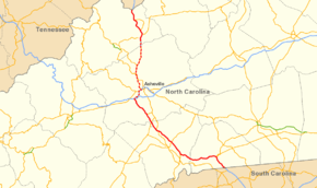
Interstate 26 in North Carolina
| ||||
|---|---|---|---|---|
 | ||||
| Route information | ||||
| Maintained by NCDOT | ||||
| Length: | 49.0 mi (78.9 km) | |||
| Existed: | 1966[1] – present | |||
| Tourist routes: |
| |||
| Major junctions | ||||
| West end: |
| |||
| East end: |
| |||
| Location | ||||
| Counties: | Madison, Buncombe, Henderson, Polk | |||
| Highway system | ||||
| ||||

Interstate 26 (I-26) in North Carolina runs through the Western part of the state, from the Tennessee border to the South Carolina border, following the Appalachian Mountains. It is part of the larger I-26, a regional interstate that runs from Kingsport, Tennessee to in Charleston, South Carolina. I-26 is mostly four lanes through North Carolina with few exceptions. Though nominally an east-west route (because of the even number convention), in North Carolina and Tennessee, the route goes nearly north-south, with the northern direction labeled "West" and vice versa.
I-26's original eastern terminus was I-40/I-240 in Asheville. Between 2003 and 2005, the road was extended further north into Tennessee. Along the segment from Mars Hill to Asheville there are FUTURE I-26 signs as some parts of the road have not yet been upgraded to Interstate Highway standards.
Route description
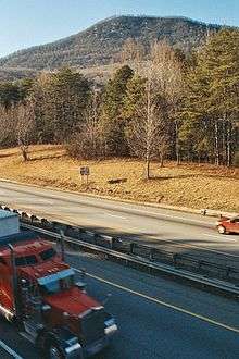
I-26, in concurrency with US 23, enters the state at Sams Gap (elevation 3,760 feet (1,150 m)), from Tennessee. In the first 9 miles (14 km), designated as a scenic byway, it features mostly six travel lanes and three runaway truck ramps along its eastbound. The freeway is also parallels US 23A, which was the original route before 2006. At exit 9, I-26 ends and Future I-26 begins; US 19 also joins from Burnsville.
At Weaverville, Future I-26 merges with US 25/US 70, coming from Marshall; however, US 25 soon disembarks in Woodfin and continues south along Merrimon Avenue. Future I-26 enters Asheville, while parallel with the French Broad River, and merges with westbound I-240/US 74A, with US 19/US 23; US 70 ends its concurrency by going eastbound I-240/US 74A instead and an additional exit at the major interchange provides access to downtown Asheville via Patton Avenue.
Crossing the French Broad River along Capt. Jeff Bowen Bridge (originally Smokey Park Highway Bridge before 2012), Future I-26/I-240 promptly exits with two-lanes to the right (same for both directions) while US 19/US 23/US 74A continue along Patton Avenue (exit 3). The interchange also features warning lights for "stopped traffic ahead", a common condition during rush hour. Between Patton Avenue (exit 3) and Haywood Road (exit 2), Future I-26/I-240 shares hidden concurrency with US 19 Bus./US 23 Bus.
At the major interchange with I-40, sometimes called Malfunction Junction,[2] both Future I-26 and I-240 end and I-26 begins again, with new concurrency with US 74. The interchange features left exit and entrances; while travelers along eastbound Future I-26/westbound I-240, access to eastbound I-40 is via NC 191 (Brevard Road - exit 1). Westbound I-40/US 74 continues on to Canton and Knoxville, eastbound I-40 provides access to nearby Biltmore Estate and further on to Hickory.
Near mile marker 36, the Blue Ridge Parkway crosses over I-26 with a 75.1-foot (22.9 m) clearance; access to the Blue Ridge Parkway is via NC 191 (exit 33).[3]
In Fletcher, I-26 goes by the Asheville Regional Airport (exit 40); 3.2 miles (5.1 km) later, US 25 rejoins (exit 44). In Hendersonville, it connects with US 64, which connect travelers to nearby Chimney Rock, Lake Lure and Brevard. Between mile markers 53 and 54, I-26 crosses the Eastern Continental Divide (elevation 2,130 feet (650 m)), at the Crest Road overpass (SR 1803). Near East Flat Rock, US 25 separates again towards Greenville; while I-26 goes southeasterly down along Dodging Hill and crosses over the Green River along Peter Guice Memorial Bridge, with a clearance of 235-foot (72 m) from the river, making it the highest bridge in North Carolina.[4]
At Howard Gap (elevation around 1,900 feet (580 m)), an additional truck lane is available on westbound I-26 for 3 miles (4.8 km). In Columbus, US 74 ends concurrency at exit 67, continuing east towards Shelby. At 71.4 miles (114.9 km) (combining I-26 and Future I-26), I-26 crosses the state line and into South Carolina.[5][6]
.jpg)
I-26 also make up part of Corridor B in the Appalachian Development Highway System (ADHS). Corridor B connects I-40, in Asheville, North Carolina, with US 23, near Lucasville, Ohio, it overlaps 9 miles (14 km) of I-26 and 22 miles (35 km) of Future I-26. ADHS provides additional funds, as authorized by the U.S. Congress, which have enabled I-26 to benefit from the successive improvements and widening along its routing within the corridor. The white-on-blue banner "Appalachian Highway" is used to mark the ADHS corridor.[7]
I-26 overlaps with one state scenic byway simply known as the "I-26 Scenic Byway." Located from the Tennessee state line to Exit 9 (US 19/US 23A), near Mars Hill. The byway is known for its unspoiled views of the North Carolina Mountains.[8]
Dedicated and memorial names
I-26 in North Carolina has one dedicated or memorialized section of freeway.
- Liston B. Ramsey Freeway - official name of I-26, on the section that overlaps with US 23 in Madison.[9]
History
I-26 appeared in the original Interstate Highway plans running from Charleston to Asheville. The road was first mapped as an under construction highway from US 25 near Hendersonville north to NC 280 (current NC 146). The first segment opened in 1966 beginning at NC 280 to the US 25 connector near East Flat Rock. In 1969, I-26 was extended north to I-40 and the South Carolina segment was extended to NC 108 near Columbus. In 1973, I-26 was extended from the US 25 connector to Saluda. Three years later I-26 was connected. The segment from Saluda to NC 108 was completed. In 2003 it was decided to extend I-26 to the Tennessee state line where a freeway existed. I-26 was routed over I-240 and went along US 23 to the north where its current routing is today.
Building through Howards Gap
One of the hardest places to build I-26 was in Howards Gap. The work was delayed by numerous landslides along Miller Mountain and Tryon Peak. Special engineering had to be done to continue work on I-26 through the area. The most important part was controlling the soil and water on the mountains and surrounding areas. This was achieved through the installation of miles of underground pipe used to drain water from the road.
Future
In 2013, the North Carolina Department of Transportation (NCDOT) reopened the idea of widening I-26 from I-40, in Asheville, to US 25, near Flat Rock. The project had been planned 10 years ago but was stopped by legal challenges. In 2015 it qualified and became part of the 2016-2025 State Transportation Improvement Program (STIP) and will cost $396 million to build. Right-of-way acquisition begins in 2018, with construction set to begin in 2020.[10]
The I-26 Connector is a $600-$800 million project to build the missing gap of I-26 through Asheville. Broken into three sections, they are all planned and funded in the 2016-2025 STIP. Section A, between Haywood Road and Brevard Road, will be a widening project with reconfiguration of ramps at Haywood, Amboy and Brevard. Section B, between north of Haywood Road to US 19/US 23/US 70, is the most expensive section of the project, at $332 million. After a review of various alternative designs, both state and federal agencies choose Alternative 4B, which will convert Patton Avenue along Bowen Bridges to local traffic and reroute I-240 along I-26 further north.[11] Section C, the I-26/I-240/I-40 interchange, will be reconfigured to include missing ramp connects and a widening of I-40 through the area. The approximately 7-mile (11 km) project will begin right-of-way acquisition in 2019, with construction on all three sections in 2021.[12][13]
Another project, between Broadway Avenue and US 19/US 23A interchanges, will be upgraded to interstate standards; by replacing bridges, adding highway width and shoulders. The project, needed so I-26 can fully be labeled along that stretch, is currently in development. The estimated cost is $99 million, with right-of-way acquisition starting in 2020 and construction in 2022.[10][14]
Exit list
| County | Location | mi | km | Old exit | New exit | Destinations | Notes |
|---|---|---|---|---|---|---|---|
| Madison | | 0.0 | 0.0 | Continuation into Tennessee; crosses through Sam's Gap | |||
| | 3.4 | 5.5 | 3 | ||||
| | 9.0 | 14.5 | 9 | North end of US 19 overlap | |||
| I-26 end / Future I-26 begin | |||||||
| Madison | Mars Hill | 11 | Existing interchanges of US 19/US 23 (upgrade to interstate standards, funded)[14] | ||||
| Buncombe | | 13 | Forks of Ivy | ||||
| Flat Creek | 15 | ||||||
| Stocksville | 17 | Flat Creek | |||||
| Weaverville | 18 | ||||||
| 19 | |||||||
| 21 | New Stock Road – Weaverville | ||||||
| Woodfin | 23 | ||||||
| 24 | Elk Mountain Road Woodfin | ||||||
| Asheville | 25 | ||||||
| Hill Street | |||||||
| Existing interchanges of I-240 (realign and upgrade to interstate standards, partially funded)[12] | |||||||
| 3B | Westgate / Resort Drive | ||||||
| 3A | |||||||
| 2 | |||||||
| 1C | Amboy Road | ||||||
| 1B | |||||||
| Future I-26 end / I-26 begin | |||||||
| Buncombe | Asheville | 31.4 | 50.5 | 1B | 31B | West end of I-240 / US 74 overlap | |
| 31.9 | 51.3 | 1A | 31A | Westbound exit and eastbound entrance | |||
| 33.0 | 53.1 | 2 | 33 | To Asheville Outlets | |||
| | 37.7 | 60.7 | 6 | 37 | |||
| Arden | 40.8 | 65.7 | 9 | 40 | To WNC Agriculture Center | ||
| Henderson | Fletcher | 44.1 | 71.0 | 13 | 44 | North end of US 25 overlap | |
| Hendersonville | 49.9 | 80.3 | 18 | 49 | Signed as exits 49A (east) and 49B (west) | ||
| 53.4 | 85.9 | 22 | 53 | Upward Road – Hendersonville | |||
| | 54.4 | 87.5 | 23 | 54 | South end of US 25 overlap; to Carl Sandburg Home and Flat Rock Playhouse | ||
| Green River | 56.5 | 90.9 | Peter Guice Memorial Bridge | ||||
| Polk | Saluda | 59.6 | 95.9 | 28 | 59 | Holbert Cove Road | |
| Columbus | 66.5 | 107.0 | 36 | 67 | East end of US 74 overlap | ||
| | 71.4 | 114.9 | Continuation into South Carolina | ||||
1.000 mi = 1.609 km; 1.000 km = 0.621 mi
| |||||||
See also
References
- ↑ "I-26 Fact Sheet" (PDF). North Carolina Department of Transportation. June 21, 2008. Retrieved June 20, 2014.
- ↑ Boyle, John (October 2, 2016). "Answer Man: Hope for Exit 44 area on I-40? Republicans first?". Asheville Citizen-Times. Retrieved October 2, 2016.
- ↑ "Uglybridges.com: Blue Ridge Parkway over I-26". Retrieved June 29, 2014.
- ↑ "Bridgehunter.com: Peter Guice Memorial Bridge". Retrieved June 29, 2014.
- ↑ Google (November 29, 2013). "Overview Map of I-26 in North Carolina" (Map). Google Maps. Google. Retrieved November 29, 2013.
- ↑ "Guide to Geologic Points of Interest Along Interstate 26". North Carolina Geologic Survey. Retrieved November 29, 2013.
- ↑ "Status of Corridors in North Carolina" (PDF). Appalachian Regional Commission. September 30, 2013. Retrieved October 25, 2014.
- ↑ "NCDOT: Scenic Byways". Retrieved June 28, 2011.
- ↑ "North Carolina Memorial Highways and other Named Facilities" (PDF). North Carolina Department of Transportation. July 15, 2004. Retrieved November 30, 2013.
- 1 2 "2016-2025 State Transportation Improvement Program (STIP) - Division 13" (PDF). North Carolina Department of Transportation. June 2015. Retrieved May 19, 2016.
- ↑ Barrett, Mark (May 19, 2016). "Connector route taking traffic off Bowen Bridge picked". Asheville Citizen-Times. Retrieved May 19, 2016.
- 1 2 "I-26 Connector, Asheville, NC". Project Details. North Carolina Department of Transportation. Retrieved December 14, 2013.
- ↑ "I-26 Connector Visualization". North Carolina Department of Transportation. Retrieved May 19, 2016.
- 1 2 "US 19/23 (Future I-26) Improvements Project". Project Details. North Carolina Department of Transportation. Retrieved December 14, 2013.
External links
 Media related to Interstate 26 in North Carolina at Wikimedia Commons
| Previous state: Tennessee |
North Carolina | Next state: South Carolina |