Tunkás Municipality
| Tunkás | |
|---|---|
| Municipality | |
 Region 3 Centro #097 | |
|
Tunkás Region 3 Centro #097 | |
| Coordinates: 20°54′04″N 88°45′05″W / 20.90111°N 88.75139°WCoordinates: 20°54′04″N 88°45′05″W / 20.90111°N 88.75139°W | |
| Country |
|
| State |
|
| Government | |
| • Type |
|
| • Municipal President | Maria Elena Dominguez Kuh[2] |
| Area | |
| • Total | 514.79 km2 (198.76 sq mi) |
| [3] | |
| Population (2010 [4]) | |
| • Total | 3,464 |
| Time zone | Central Standard Time (UTC-6) |
| • Summer (DST) | Central Daylight Time (UTC-5) |
| INEGI Code | 097 |
| Major Airport | Merida (Manuel Crescencio Rejón) International Airport |
| IATA Code | MID |
| ICAO Code | MMMD |
| Website | Official Website |
Tunkás Municipality (In the Yucatec Maya Language: “bad or ugly stone”) is one of the 106 municipalities in the Mexican state of Yucatán containing (514.79 km2) of land and located roughly 98 km east of the city of Mérida.[2]
The municipality relies on farming for the majority of its economy, along with remittances from emigrants. Tunakseños migrate to the beach resorts of Quintana Roo, mostly Cancún and Playa del Carmen, as well as to the United States. Large concentrations of people from Tunkás can be found in Inglewood and Anaheim, both in California.
History
In ancient history, the area belonged to the chieftainship of Cupul until the conquest. At colonization, Tunkás became part of the encomienda system and the encomenderos listed in 1735 were Diego Ramón del Castillo y Juan and Baltazar de la Cámara. In 1821, Yucatán was declared independent of the Spanish Crown. In 1825 the area was part of the Valladolid region.[2]
Governance
The municipal president is elected for a term of three years. The president appoints four Councilpersons to serve on the board for three year terms, as the Secretary and councilors of public services, public security, and ecology.[5]
Communities
The head of the municipality is Tunkás, Yucatán. There are 15 inhabited communities in the municipality: Canasultun, Ebulá, Franz, Kancabal, Kancabchen, Onichén, San Antonio Chuc, San Dimas, San José Pibtuch, San Román, Tabichén, Tunkás, Xcauil, Yaxhá, and Yohuas. The major population areas are shown below:[2]
| Community | Population |
|---|---|
| Entire Municipality (2010) | 3,464[4] |
| San Antonio Chuc | 248 in 2005[6] |
| San José Pibtuch | 188 in 2005[7] |
| Tunkás | 2812 in 2005[8] |
Local festivals
Every year from 20 to 24 December the area celebrates a festival for St. Thomas the Apostle, patron of the town. From 30 January to 2 February an annual fair which attracts people from other areas of the region is held.[3]
Tourist attractions
- Templo de Tunkás, the colonial-era church
- Municipal Palace
- Cenote Chan
- Cenote Chan Lukun X’azul
- Cenote Mumundzonot
- Cenote X’tekdzonot
References
- ↑ "Gobiernos: Presidentes Municipales". Partido Acción Nacional (in Spanish). Mexico City, Mexico: Partido Acción Nacional. Retrieved 3 June 2015.
- 1 2 3 4 "Municipios de Yucatán » Tunkás". Gobierno del Estado de Yucatán (in Spanish). Mérida, Mexico: Gobierno del Estado de Yucatán. Retrieved 3 June 2015.
- 1 2 "Nuestros municipios - Tunkás". Retrieved 12 November 2009.
- 1 2 "Mexico In Figures: Motul, Yucatán". INEGI (in Spanish and English). Aguascalientes, México: Instituto Nacional de Estadística y Geografía (INEGI). Retrieved 3 June 2015.
- ↑ "Tunkás". inafed (in Spanish). Mérida, Mexico: Enciclopedia de Los Municipios y Delegaciones de México. Retrieved 4 June 2015.
- ↑ "San Antonio Chuc". PueblosAmerica (in Spanish). PueblosAmerica. 2005. Retrieved 3 June 2015.
- ↑ "San José Pibtuch". PueblosAmerica (in Spanish). PueblosAmerica. 2005. Retrieved 3 June 2015.
- ↑ "Tunkás". PueblosAmerica (in Spanish). PueblosAmerica. 2005. Retrieved 3 June 2015.
Mérida (capital) | |||||||||||||||||||||||||||
| Topics | 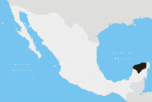 | ||||||||||||||||||||||||||
| Metros | |||||||||||||||||||||||||||
| Larger cities | |||||||||||||||||||||||||||
| Smaller cities |
| ||||||||||||||||||||||||||
| Municipalities |
| ||||||||||||||||||||||||||