Delta–Mendota Canal
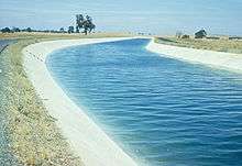
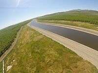
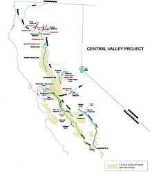
The Delta–Mendota Canal is a 117 mi (188 km) aqueduct in central California, United States. It is part of the Central Valley Project and its purpose is to replace water in the San Joaquin River that is diverted into Madera Canal and Friant-Kern Canal at Friant Dam. Average annual throughput is 1,993,000 acre feet (2.458 km3).
The canal begins at the C.W. Bill Jones Pumping Plant (formerly the Tracy Pumping Plant), which raises water 197 ft (60 m) from the Sacramento-San Joaquin Delta.
The canal runs south along the western edge of the San Joaquin Valley, parallel to the California Aqueduct for most of its journey, but diverges to the east after passing San Luis Reservoir, which receives some of its water.
The canal also depends secondarily on the outflows of the Clifton Court Forebay.
Use
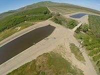
The water is pumped from the canal into O'Neill Forebay, and then is pumped into San Luis Reservoir by the Gianelli Pumping-Generating Plant. Occasionally, water from O'Neill Forebay is released into the canal. The Delta–Mendota Canal ends at Mendota Pool, on the San Joaquin River near the town of Mendota, 30 mi (48 km) west of Fresno. The Delta–Mendota Canal capacity is 4,600 cu ft/s (130 m3/s) and gradually decreases to 3,211 cu ft/s (90.9 m3/s) at its terminus.
History
The Delta–Mendota Canal was completed in 1951 and is operated by the United States Bureau of Reclamation and the San Luis Delta Mendota Water Authority, which is charged with maintaining the quality of the water that is discharged from the south end of the canal. The canal passes through parts of Alameda, San Joaquin, Stanislaus, Merced, and Fresno counties.
References
- U.S. Geological Survey Geographic Names Information System: Delta-Mendota Canal
- United States Bureau of Reclamation
- USGS annual flow data
Coordinates: 37°05′34″N 121°02′27″W / 37.092721°N 121.0407554°W