Topaz Lake, Nevada
For the lake of the same name, see Topaz Lake.
| Topaz Lake, Nevada | |
|---|---|
| Census-designated place | |
 Topaz Lake Location of Topaz Lake, Nevada | |
| Coordinates: 38°41′44″N 119°32′38″W / 38.69556°N 119.54389°WCoordinates: 38°41′44″N 119°32′38″W / 38.69556°N 119.54389°W | |
| Country | United States |
| State | Nevada |
| Area | |
| • Total | 1.7 sq mi (4.4 km2) |
| • Land | 1.2 sq mi (3.1 km2) |
| • Water | 0.5 sq mi (1.3 km2) |
| Elevation | 5,080 ft (1,550 m) |
| Population (2010) | |
| • Total | 157 |
| • Density | 131/sq mi (50.6/km2) |
| Time zone | Pacific (PST) (UTC-8) |
| • Summer (DST) | PDT (UTC-7) |
| Area code(s) | 775 |
| FIPS code | 32-74200 |
Topaz Lake is a census-designated place (CDP) in Douglas County, Nevada, United States. The population was 157 at the 2010 census.[1]
Geography
The CDP is located on the northwest shore of Topaz Lake just north of the California border. U.S. Route 395 runs through the community, leading north 37 miles (60 km) to Carson City and south 66 miles (106 km) to Mono Lake in California. According to the United States Census Bureau, the Topaz Lake CDP has a total area of 1.7 square miles (4.4 km2), of which 1.2 square miles (3.1 km2) is land and 0.50 square miles (1.3 km2), or 29.87%, is water.[1]
References
- 1 2 "Geographic Identifiers: 2010 Demographic Profile Data (G001): Topaz Lake CDP, Nevada". U.S. Census Bureau, American Factfinder. Retrieved January 24, 2013.
Municipalities and communities of Douglas County, Nevada, United States | ||
|---|---|---|
| CDPs | 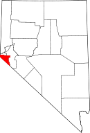 | |
| Unincorporated communities | ||
This article is issued from Wikipedia - version of the 9/18/2015. The text is available under the Creative Commons Attribution/Share Alike but additional terms may apply for the media files.