Carter Springs, Nevada
| Carter Springs, Nevada | |
|---|---|
| Census-designated place | |
 Carter Springs Location of Carter Springs, Nevada | |
| Coordinates: 38°51′46″N 119°39′12″W / 38.86278°N 119.65333°WCoordinates: 38°51′46″N 119°39′12″W / 38.86278°N 119.65333°W | |
| Country | United States |
| State | Nevada |
| Area | |
| • Total | 2.8 sq mi (7.3 km2) |
| • Land | 2.8 sq mi (7.3 km2) |
| • Water | 0.0 sq mi (0.0 km2) |
| Elevation | 5,450 ft (1,660 m) |
| Population (2010) | |
| • Total | 553 |
| • Density | 200/sq mi (76/km2) |
| Time zone | Pacific (PST) (UTC-8) |
| • Summer (DST) | PDT (UTC-7) |
| Area code(s) | 775 |
| FIPS code | 32-10200 |
Carter Springs is a census-designated place (CDP) in Douglas County, Nevada, United States. The population was 553 at the 2010 census.[1]
Geography
Carter Springs is 9 miles (14 km) southeast of Minden on the north side of U.S. Route 395. According to the United States Census Bureau, the CDP has a total area of 2.8 square miles (7.3 km2), all of it land.[1]
References
- 1 2 "Geographic Identifiers: 2010 Demographic Profile Data (G001): Carter Springs CDP, Nevada". U.S. Census Bureau, American Factfinder. Retrieved January 24, 2013.
Municipalities and communities of Douglas County, Nevada, United States | ||
|---|---|---|
| CDPs | 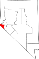 | |
| Unincorporated communities | ||
This article is issued from Wikipedia - version of the 11/21/2013. The text is available under the Creative Commons Attribution/Share Alike but additional terms may apply for the media files.