Johnson Lane, Nevada
| Johnson Lane, Nevada | |
|---|---|
| Census-designated place | |
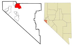 Location of Johnson Lane, Nevada | |
| Coordinates: 39°2′15″N 119°43′48″W / 39.03750°N 119.73000°WCoordinates: 39°2′15″N 119°43′48″W / 39.03750°N 119.73000°W | |
| Country | United States |
| State | Nevada |
| Area | |
| • Total | 21.9 sq mi (56.7 km2) |
| • Land | 21.9 sq mi (56.6 km2) |
| • Water | 0.008 sq mi (0.02 km2) |
| Elevation | 4,820 ft (1,469 m) |
| Population (2010) | |
| • Total | 6,490 |
| • Density | 300/sq mi (110/km2) |
| Time zone | Pacific (PST) (UTC-8) |
| • Summer (DST) | PDT (UTC-7) |
| FIPS code | 32-37190 |
| GNIS feature ID | 1867348 |
Johnson Lane is a census-designated place (CDP) in Douglas County, Nevada, United States. It lies in the south side of the Carson City metropolitan area. The population was 6,490 at the 2010 census.[1]
Geography
Johnson Lane is located at 39°2′15″N 119°43′48″W / 39.03750°N 119.73000°W (39.037535, -119.729971).[2]
According to the United States Census Bureau, the CDP has a total area of 21.88 square miles (56.67 km2), of which 21.87 square miles (56.65 km2) is land and 0.008 square miles (0.02 km2), or 0.03%, is water.[1]
Demographics
| Historical population | |||
|---|---|---|---|
| Census | Pop. | %± | |
| 1990 | 2,551 | — | |
| 2000 | 4,857 | 90.4% | |
| 2010 | 6,490 | 33.6% | |
| source:[3] | |||
As of the census[4] of 2000, there were 4,837 people, 1,786 households, and 1,496 families residing in the CDP. The population density was 226.2 people per square mile (87.4/km²). There were 1,829 housing units at an average density of 85.5 per square mile (33.0/km²). The racial makeup of the CDP was 95.29% White, 0.12% African American, 0.76% Native American, 0.91% Asian, 0.08% Pacific Islander, 0.64% from other races, and 2.19% from two or more races. Hispanic or Latino of any race were 4.38% of the population.
There were 1,786 households out of which 33.5% had children under the age of 18 living with them, 75.1% were married couples living together, 5.3% had a female householder with no husband present, and 16.2% were non-families. 11.5% of all households were made up of individuals and 3.1% had someone living alone who was 65 years of age or older. The average household size was 2.71 and the average family size was 2.91.
In the CDP the population was spread out with 24.5% under the age of 18, 4.7% from 18 to 24, 25.6% from 25 to 44, 32.1% from 45 to 64, and 13.0% who were 65 years of age or older. The median age was 43 years. For every 100 females there were 99.7 males. For every 100 females age 18 and over, there were 99.6 males.
The median income for a household in the CDP was $59,130, and the median income for a family was $60,918. Males had a median income of $46,329 versus $29,907 for females. The per capita income for the CDP was $24,247. About 4.3% of families and 6.1% of the population were below the poverty line, including 6.9% of those under age 18 and 5.1% of those age 65 or over.
References
- 1 2 "Geographic Identifiers: 2010 Demographic Profile Data (G001): Johnson Lane CDP, Nevada". U.S. Census Bureau, American Factfinder. Retrieved January 24, 2013.
- ↑ "US Gazetteer files: 2010, 2000, and 1990". United States Census Bureau. 2011-02-12. Retrieved 2011-04-23.
- ↑ "CENSUS OF POPULATION AND HOUSING (1790-2000)". U.S. Census Bureau. Retrieved 2010-07-17.
- ↑ "American FactFinder". United States Census Bureau. Retrieved 2008-01-31.
Municipalities and communities of Douglas County, Nevada, United States | ||
|---|---|---|
| CDPs | 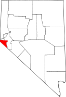 | |
| Unincorporated communities | ||