Perryton, Texas
| Perryton, Texas | |
|---|---|
| City | |
 Location of Perryton, Texas | |
| Coordinates: 36°23′30″N 100°48′22″W / 36.39167°N 100.80611°WCoordinates: 36°23′30″N 100°48′22″W / 36.39167°N 100.80611°W | |
| Area | |
| • Total | 4.5 sq mi (11.5 km2) |
| • Land | 4.4 sq mi (11.5 km2) |
| • Water | 0.0 sq mi (0.1 km2) |
| Elevation | 2,940 ft (896 m) |
| Population (2000) | |
| • Total | 7,774 |
| • Density | 1,753.2/sq mi (676.9/km2) |
| ZIP code | 79070 |
| Area code(s) | 806 |
Perryton is a city in Ochiltree County, Texas, United States. The population was 8,802 at the 2010 census. It is the county seat of Ochiltree County.[1]
Geography
Perryton is located at 36°23′30″N 100°48′22″W / 36.39167°N 100.80611°W (36.391752, -100.806109).[2] According to the United States Census Bureau, the city has a total area of 4.5 square miles (12 km2), of which 4.4 square miles (11 km2) is land and 0.04 square miles (0.10 km2) (0.45%) is water.
Climate
According to the Köppen Climate Classification system, Perryton has a semi-arid climate, abbreviated "BSk" on climate maps.[3] It has significant similarities with the humid subtropical climate since rainfall is quite high for semi-arid summers. Summers are hot, but somewhat less intense than southerly Texas areas, whereas winter nights are so cold the coldest month almost falls below the 0 °C (32 °F) daily mean. This indicates heavy continental influence courtesy of its far inland position.
| Climate data for Perryton | |||||||||||||
|---|---|---|---|---|---|---|---|---|---|---|---|---|---|
| Month | Jan | Feb | Mar | Apr | May | Jun | Jul | Aug | Sep | Oct | Nov | Dec | Year |
| Record high °C (°F) | 29 (84) |
28 (82) |
33 (91) |
36 (97) |
41 (106) |
45 (113) |
45 (113) |
43 (109) |
42 (108) |
37 (99) |
31 (88) |
29 (84) |
45 (113) |
| Average high °C (°F) | 9.0 (48.2) |
10.9 (51.6) |
15.9 (60.6) |
20.9 (69.6) |
25.6 (78.1) |
30.6 (87.1) |
33.6 (92.5) |
32.7 (90.9) |
28.4 (83.1) |
21.7 (71.1) |
15.1 (59.2) |
8.6 (47.5) |
21.1 (70) |
| Daily mean °C (°F) | 0.9 (33.6) |
2.6 (36.7) |
7.2 (45) |
12.0 (53.6) |
17.3 (63.1) |
22.6 (72.7) |
25.4 (77.7) |
24.8 (76.6) |
20.3 (68.5) |
13.5 (56.3) |
6.7 (44.1) |
1.1 (34) |
12.9 (55.2) |
| Average low °C (°F) | −7.2 (19) |
−5.6 (21.9) |
−1.6 (29.1) |
3.1 (37.6) |
9.1 (48.4) |
14.6 (58.3) |
17.3 (63.1) |
16.9 (62.4) |
12.2 (54) |
5.4 (41.7) |
−1.7 (28.9) |
−6.4 (20.5) |
4.7 (40.5) |
| Record low °C (°F) | −28 (−18) |
−25 (−13) |
−24 (−11) |
−12 (10) |
−6 (21) |
3 (37) |
8 (46) |
5 (41) |
0 (32) |
−12 (10) |
−16 (3) |
−26 (−15) |
−26 (−15) |
| Average precipitation mm (inches) | 12.7 (0.5) |
15.2 (0.598) |
45.7 (1.799) |
45.7 (1.799) |
76.2 (3) |
83.8 (3.299) |
78.7 (3.098) |
66.0 (2.598) |
48.3 (1.902) |
45.7 (1.799) |
22.9 (0.902) |
20.3 (0.799) |
561.3 (22.098) |
| Source: [4] | |||||||||||||
Demographics
| Historical population | |||
|---|---|---|---|
| Census | Pop. | %± | |
| 1930 | 2,824 | — | |
| 1940 | 2,325 | −17.7% | |
| 1950 | 4,417 | 90.0% | |
| 1960 | 7,903 | 78.9% | |
| 1970 | 7,810 | −1.2% | |
| 1980 | 7,991 | 2.3% | |
| 1990 | 7,607 | −4.8% | |
| 2000 | 7,774 | 2.2% | |
| 2010 | 8,802 | 13.2% | |
| Est. 2015 | 9,252 | [5] | 5.1% |
At the 2000 census,[7] there were 7,774 people, 2,785 households and 2,113 families residing in the city. The population density was 1,753.2 per square mile (677.6/km²). There were 3,180 housing units at an average density of 717.2 per square mile (277.2/km²). The racial makeup of the city was 85.23% White, 0.15% African American, 0.98% Native American, 0.40% Asian, 0.01% Pacific Islander, 11.10% from other races, and 2.12% from two or more races. Hispanic or Latino of any race were 34.13% of the population.
There were 2,785 households of which 42.3% had children under the age of 18 living with them, 62.6% were married couples living together, 8.7% had a female householder with no husband present, and 24.1% were non-families. 21.3% of all households were made up of individuals and 9.5% had someone living alone who was 65 years of age or older. The average household size was 2.77 and the average family size was 3.22.
Age distribution was 31.3% under the age of 18, 8.7% from 18 to 24, 28.9% from 25 to 44, 19.8% from 45 to 64, and 11.3% who were 65 years of age or older. The median age was 33 years. For every 100 females there were 98.1 males. For every 100 females age 18 and over, there were 94.4 males.
The median household income was $37,363, and the median family income was $45,045. Males had a median income of $31,803 compared with $19,694 for females. The per capita income for the city was $16,431. About 9.7% of families and 13.2% of the population were below the poverty line, including 18.4% of those under age 18 and 10.2% of those age 65 or over.
Education
The City of Perryton is served by the Perryton Independent School District and the Perryton High School.
Notable people
- Caleb Campbell, National Football League player
- Jeremy Campbell, 2008 Summer Paralympics athlete
- John R. Erickson, author of the Hank the Cowdog Series
- Keith Flowers, NFL player
- Mike Hargrove, Major League Baseball player and manager
Gallery
 Perryton: "Wheatheart of the Nation"
 Whigham Park (established 1934) offers two free nights of camping.
 U.S. Highway 83 as it proceeds through downtown.
 Former Hotel Perryton in downtown.
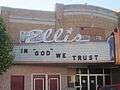 Ellis Theater in downtown.
References
- ↑ "Find a County". National Association of Counties. Retrieved 2011-06-07.
- ↑ "US Gazetteer files: 2010, 2000, and 1990". United States Census Bureau. 2011-02-12. Retrieved 2011-04-23.
- ↑ Climate Summary for Perryton, Texas
- ↑ "Perryton, Texas Temperature Averages". Weatherbase. Retrieved 21 June 2015.
- ↑ "Annual Estimates of the Resident Population for Incorporated Places: April 1, 2010 to July 1, 2015". Retrieved July 2, 2016.
- ↑ "Census of Population and Housing". Census.gov. Retrieved June 4, 2015.
- ↑ "American FactFinder". United States Census Bureau. Retrieved 2008-01-31.
External links
Municipalities and communities of Ochiltree County, Texas, United States | ||
|---|---|---|
| City | 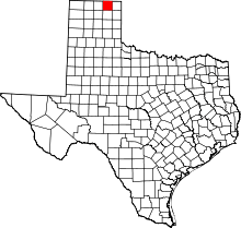 | |
| Town | ||
| Unincorporated communities | ||
| Footnotes | ‡This populated place also has portions in an adjacent county or counties | |
