Tagliolo Monferrato
| Tagliolo Monferrato | |
|---|---|
| Comune | |
| Comune di Tagliolo Monferrato | |
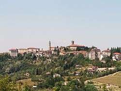 | |
 Tagliolo Monferrato Location of Tagliolo Monferrato in Italy | |
| Coordinates: 44°38′N 8°40′E / 44.633°N 8.667°ECoordinates: 44°38′N 8°40′E / 44.633°N 8.667°E | |
| Country | Italy |
| Region | Piedmont |
| Province / Metropolitan city | Province of Alessandria (AL) |
| Frazioni | Cherli, Grossi, Varo, Pessino, Caraffa, Mongiardino |
| Area | |
| • Total | 25.9 km2 (10.0 sq mi) |
| Elevation | 315 m (1,033 ft) |
| Population (Dec. 2004) | |
| • Total | 1,499 |
| • Density | 58/km2 (150/sq mi) |
| Demonym(s) | Tagliolesi |
| Time zone | CET (UTC+1) |
| • Summer (DST) | CEST (UTC+2) |
| Postal code | 15070 |
| Dialing code | 0143 |
Tagliolo Monferrato is a comune (municipality) in the Province of Alessandria in the Italian region Piedmont, located about 90 kilometres (56 mi) southeast of Turin and about 30 kilometres (19 mi) south of Alessandria. As of 31 December 2004, it had a population of 1,499 and an area of 25.9 square kilometres (10.0 sq mi).[1]
The municipality of Tagliolo Monferrato contains the frazioni (subdivisions, mainly villages and hamlets) Cherli, Grossi, Varo, Pessino, Caraffa, and Mongiardino.
Tagliolo Monferrato borders the following municipalities: Belforte Monferrato, Bosio, Casaleggio Boiro, Lerma, Ovada, Rossiglione, and Silvano d'Orba.
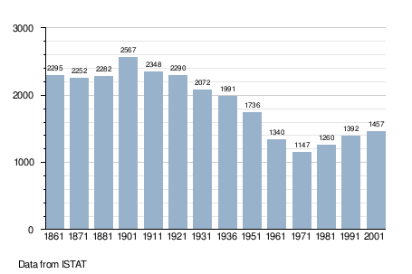
Demographic evolution
Related articles
References
This article is issued from Wikipedia - version of the 4/9/2016. The text is available under the Creative Commons Attribution/Share Alike but additional terms may apply for the media files.