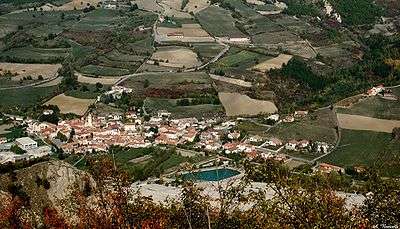
Cantalupo Ligure
| Cantalupo Ligure | |
|---|---|
| Comune | |
| Comune di Cantalupo Ligure | |
 | |
 Cantalupo Ligure Location of Cantalupo Ligure in Italy | |
| Coordinates: 44°43′N 9°3′E / 44.717°N 9.050°ECoordinates: 44°43′N 9°3′E / 44.717°N 9.050°E | |
| Country | Italy |
| Region | Piedmont |
| Province / Metropolitan city | Province of Alessandria (AL) |
| Frazioni | Pallavicino, Borgo Adorno, Pessinate, Semega, Campana, Zebedassi, Besante, Arborelle, Colonne, Pertuso, Prato, Merlassino, Costa Merlassino |
| Area | |
| • Total | 24.0 km2 (9.3 sq mi) |
| Elevation | 383 m (1,257 ft) |
| Population (Dec. 2004) | |
| • Total | 552 |
| • Density | 23/km2 (60/sq mi) |
| Demonym(s) | Cantalupesi |
| Time zone | CET (UTC+1) |
| • Summer (DST) | CEST (UTC+2) |
| Postal code | 15060 |
| Dialing code | 0143 |
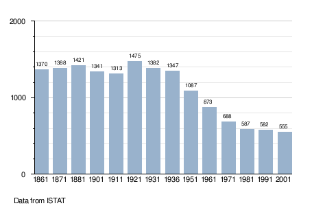
Cantalupo Ligure is a comune (municipality) in the Province of Alessandria in the Italian region Piedmont, located about 110 kilometres (68 mi) southeast of Turin and about 40 kilometres (25 mi) southeast of Alessandria. As of 31 December 2004, it had a population of 552 and an area of 24.0 square kilometres (9.3 sq mi).[1]
The municipality of Cantalupo Ligure contains the frazioni (subdivisions, mainly villages and hamlets) Pallavicino, Borgo Adorno, Pessinate, Semega, Campana, Zebedassi, Besante, Arborelle, Colonne, Pertuso, Prato, Merlassino, and Costa Merlassino.
Cantalupo Ligure borders the following municipalities: Albera Ligure, Borghetto di Borbera, Dernice, Montacuto, Roccaforte Ligure, and Rocchetta Ligure.
Demographic evolution