Dernice
| Dernice | |
|---|---|
| Comune | |
| Comune di Dernice | |
 Dernice Location of Dernice in Italy | |
| Coordinates: 44°46′N 9°3′E / 44.767°N 9.050°ECoordinates: 44°46′N 9°3′E / 44.767°N 9.050°E | |
| Country | Italy |
| Region | Piedmont |
| Province / Metropolitan city | Province of Alessandria (AL) |
| Frazioni | Montebore |
| Area | |
| • Total | 18.3 km2 (7.1 sq mi) |
| Elevation | 600 m (2,000 ft) |
| Population (Dec. 2004) | |
| • Total | 235 |
| • Density | 13/km2 (33/sq mi) |
| Demonym(s) | Dernicesi |
| Time zone | CET (UTC+1) |
| • Summer (DST) | CEST (UTC+2) |
| Postal code | 15056 |
| Dialing code | 0131 |
Dernice is a comune (municipality) in the Province of Alessandria in the Italian region Piedmont, located about 110 kilometres (68 mi) southeast of Turin and about 40 kilometres (25 mi) southeast of Alessandria. As of 31 December 2004, it had a population of 235 and an area of 18.3 square kilometres (7.1 sq mi).[1]
The municipality of Dernice contains the frazione (subdivision) Montebore.
Dernice borders the following municipalities: Borghetto di Borbera, Brignano-Frascata, Cantalupo Ligure, Garbagna, Montacuto, and San Sebastiano Curone.
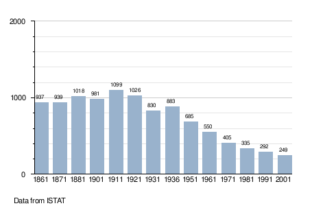
Demographic evolution
References
This article is issued from Wikipedia - version of the 1/31/2015. The text is available under the Creative Commons Attribution/Share Alike but additional terms may apply for the media files.