San Salvatore Monferrato
| San Salvatore Monferrato | ||
|---|---|---|
| Comune | ||
| Comune di San Salvatore Monferrato | ||
 | ||
| ||
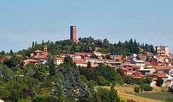
 San Salvatore Monferrato Location of San Salvatore Monferrato in Italy | ||
| Coordinates: 44°59′42″N 8°34′1″E / 44.99500°N 8.56694°E | ||
| Country | Italy | |
| Region | Piedmont | |
| Province / Metropolitan city | Alessandria (AL) | |
| Frazioni | Fosseto, Frescondino, Piazzolo, Salcido, Valdolenga, Valparolo | |
| Government | ||
| • Mayor | Corrado Tagliabue (Lista civica. Elected 30 May 2006; re-elected 16 May 2011) | |
| Area | ||
| • Total | 31.65 km2 (12.22 sq mi) | |
| Elevation | 205 m (673 ft) | |
| Population (2005[1]) | ||
| • Total | 4,587 | |
| • Density | 140/km2 (380/sq mi) | |
| Demonym(s) | Sansalvatoresi | |
| Time zone | CET (UTC+1) | |
| • Summer (DST) | CEST (UTC+2) | |
| Postal code | 15046 | |
| Dialing code | 0131 | |

San Salvatore Monferrato is a comune (municipality) in the Province of Alessandria in the Italian region Piedmont, located about 70 kilometres (43 mi) east of Turin and about 10 kilometres (6 mi) northwest of Alessandria. As of 31 December 2004, it had a population of 4,629 and an area of 31.6 square kilometres (12.2 sq mi).
Main sights
The tower of the Paleologi was erected for Theodore II, Marquess of Montferrat.
Also of interest are the 16th century churches of San Martino e San Siro. At the communal cemetery of the town is notable the grave of Paolo Provera, surnamed Tantasà, a curious example of outsider art.
Notable people
- Iginio Ugo Tarchetti (1839–1869), a novelist, also poet and journalist, and part of the Milanese Scapigliatura.
- Paolo Provera (Tantasà) (1850–1930), an outsider artist.
Eugenio "Gene" Guglielmi (1947–), a beat folksinger.
References
| Wikimedia Commons has media related to San Salvatore Monferrato. |
This article is issued from Wikipedia - version of the 1/31/2015. The text is available under the Creative Commons Attribution/Share Alike but additional terms may apply for the media files.