Province of Alessandria
| Province of Alessandria | |
|---|---|
| Province | |
 | |
 Location of the Province of Alessandria within Italy | |
| Country |
|
| Region |
|
| Capital(s) | Alessandria |
| Comuni | 190 |
| Government | |
| • President | Maria Rita Rossa |
| Area | |
| • Total | 3,560 km2 (1,370 sq mi) |
| Population (28 February 2015) | |
| • Total | 431,202 |
| • Density | 120/km2 (310/sq mi) |
| Time zone | CET (UTC+1) |
| • Summer (DST) | CEST (UTC+2) |
| Postal code | 15010-15013, 15015-15018, 15020-15036, 15038-15046, 15048-15053, 15055-15079, 15100 |
| Telephone prefix | 010, 019, 0131, 0141, 0142, 0143, 0144 |
| Vehicle registration | AL |
| ISTAT | 06 |
The Province of Alessandria (Italian: Provincia di Alessandria) is an Italian province, with a population of some 430,000, which forms the southeastern part of the region of Piedmont. The provincial capital is the city of Alessandria.
With an area of 3,560 square kilometres (1,370 sq mi) it is the third largest province of Piedmont after those of Cuneo and Turin. To the north it borders on the Province of Vercelli and to the west on the provinces of Turin and Asti. It shares its southern border with Liguria (provinces of Savona and Genoa). Its south-east corner touches the Province of Piacenza in Emilia Romagna, while to the east it borders on the Lombard Province of Pavia.
History
The province was created by the Royal Decree n. 3702 of 23 October 1859, the Legge Rattazzi, as a union of five of the six provinces which had formed the Division of Alessandria (the provinces of Alessandria, Acqui, Asti, Casale and Tortona) plus the Province of Novi which had formed part of the Division of Genoa. In 1935 the area of Asti was established as the separate Province of Asti.
Communes
There are 190 communes in the province[1]
Main sights

The Sacred Mountain of Crea (Italian: Sacro Monte di Crea) is a Roman Catholic Devotional Complex in the comune of Serralunga di Crea (Montferrat), near Alessandria. It is one of the nine Sacri Monti of Piedmont and Lombardy, included in UNESCO World Heritage list. Its construction was begun in 1589, around a former Sanctuary of St. Mary whose creation is traditionally attributed to Saint Eusebius of Vercelli around 350 AD.
See also
References
External links
-
 Media related to Province of Alessandria at Wikimedia Commons
 - Official website
- Official web site for European Sacred Mounts
- MonferratoArte (Italian) A historical and bibliographical directory of artists active in the extra-urban Churches of the Diocese of Casale Monferrato.
- Laws and Statutes of the Carpeneto commune, 15th century, Center for Digital Initiatives, University of Vermont Libraries
| Provinces and metropolitan cities | 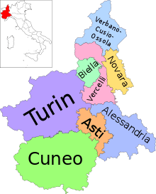 | |
|---|---|---|
| History | ||
| Politics and government | ||
| Education and culture | ||
Categories | ||
Coordinates: 44°54′48″N 8°37′12″E / 44.91333°N 8.62000°E