Southern Cross Drive
- Distinguish from the road of the same name in Cape Town, South Africa, on the eastern side of Table Mountain.
| Southern Cross Drive New South Wales | |
|---|---|
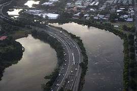 | |
| An aerial view of the Southern Cross Drive in 2012 with the Botany Lakes and the Mill Steam astride the road. | |
| Coordinates | 33°56′8″S 151°12′30″E / 33.93556°S 151.20833°ECoordinates: 33°56′8″S 151°12′30″E / 33.93556°S 151.20833°E |
| General information | |
| Type | Motorway |
| Length | 4.8 km (3.0 mi) |
| Route number(s) |
|
| Former route number | |
| Major junctions | |
| North end |
Kensington, Sydney |
| |
| South end |
Mascot, Sydney |
| Location(s) | |
| Major suburbs / towns | Eastlakes, Pagewood, Rosebery |
| Highway system | |
|
Highways in Australia National Highway • Freeways in Australia Highways in New South Wales | |
| |
The Southern Cross Drive is a 4.8 km (3 mi) dual carriage untolled motorway in Sydney, New South Wales, Australia. Part of the M1 and Sydney Orbital Network, the road, a freeway that opened in 1969, links the Eastern Distributor and South Dowling Street at Kensington in the north to General Holmes Drive at Sydney Airport in the south.
In August 2013 the Southern Cross Drive carried about 20,000 vehicles per day, both north and southbound.[4]
Southern Cross Drive was originally built to provide access to the Sydney central business district for suburbs in Southern Sydney and South-eastern Sydney. Part of the road is built over reclaimed swampland including the Mill Pond, the Mill Steam, and Botany Dams, much of which has been reclaimed for golf courses including the Eastlakes Golf Club, The Lakes Golf Club and Bonnie Doon Golf Club.
Alignment
With the development of many other motorways and freeways, Southern Cross Drive is part of the 110-kilometre (68 mi) Sydney Orbital Network, providing links without interruption between Greater Western Sydney, Eastern Suburbs, the North Shore and Hills District. It allows a continuous link from the M5 Motorway, General Holmes Drive, Westlink M7, Eastern Distributor, Cahill Expressway, Sydney Harbour Tunnel, Sydney Harbour Bridge, Warringah Freeway, M4 Motorway, Gore Hill Freeway, Lane Cove Tunnel and the M2 Hills Motorway.
It has connection points at Mill Pond Drive / Botany Road, Wentworth Avenue, Link Road and O'Dea / Todman Avenues. There were plans to construct south-facing ramps from Gardeners Road to Southern Cross Drive.[5][6]
The road also provides suburban access to the Sydney suburbs of Eastlakes, Pagewood, Mascot, Botany and adjoining suburbs.
South of Wentworth Avenue and north of Botany Road, Southern Cross Drive is elevated above the ARTC Southern Sydney Freight Line.[7] A road bridge carrying Gardeners Road was completed in 1969, elevated above South Cross Drive at Eastlakes.[8]
Exits and interchanges
| LGA | Location | km | mi | Destinations | Notes |
|---|---|---|---|---|---|
| Randwick | Kensington | 0 | 0.0 | South Dowling Street – Kensington, Zetland | Northbound exit and southbound entrance only |
| 0.5 | 0.31 | North-eastern terminus; continues north as Eastern Distributor and Sydney Orbital | |||
| Rosebery | 0.6 | 0.37 | Link Road – Rosebery | Northbound exit and entrance only | |
| Bayside | Eastlakes | 3.5 | 2.2 | Wentworth Avenue – Maroubra, Mascot | Northbound entry and southbound exit only |
| Botany | 4.1 | 2.5 | Botany Road – Botany, Mascot, Arncliffe | Northbound entry and southbound and westbound exit only | |
| 4.1 | 2.5 | Northbound entry and eastbound and westbound exit only | |||
| 4.8 | 3.0 | South-eastern terminus; continues southeast as General Holmes Drive and Sydney Orbital | |||
| 1.000 mi = 1.609 km; 1.000 km = 0.621 mi | |||||
Gallery
 Southern Cross Drive, southerly direction, at the Link Road, Rosebery entrance. Also visible are lane markings to notify motorists of the approaching southern entrance to the Eastern Distributor.
 Crossing over Wentworth Avenue with surrounding golf courses.
See also
References
- ↑ "Metroad 1: Waterfall to Wahroonga via Sydney Harbour Tunnel". OzRoads: The Australian Roads. Retrieved 8 October 2016.
- ↑ "NSW Metroad 1: Former Alignment: Southern Cross Drive to Cahill Expressway". OzRoads: The Australian Roads. Retrieved 8 October 2016.
- 1 2 "NSW State Route 64: Deccommissioned". OzRoads: The Australian Roads. Retrieved 8 October 2016.
- ↑ "Airport East Precinct: Addendum review of environmental factors" (PDF). Roads & Maritime Services. April 2016. p. 30. Retrieved 8 October 2016.
- ↑ "Southern Cross Drive and Gardeners Road, Eastlakes". Roads & Maritime Services.
- ↑ "RTA Annual Report 2006 Appendices" (PDF). Roads & Traffic Authority. 30 June 2006. p. 151. Retrieved 8 October 2016.
- ↑ SMEC Holdings (June 2014). "Appendix J: Review of Environmental Factors" (PDF). WestConnex Enabling Works – Airport east precinct: Review of Environmental Factors. Roads & Maritime Services. p. 20. Retrieved 8 October 2016.
- ↑ "Metroads: Steel bridges". The History of Sydney: Late 20th Century: 1946 - 2000. Visit Sydney Australia. 2015. Retrieved 8 October 2016.