Stuyvesant Cove Park
Coordinates: 40°43′59.5″N 73°58′26.5″W / 40.733194°N 73.974028°W
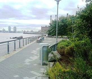
Stuyvesant Cove Park is a 1.9-acre (7,700 m2) public park on the East Side of the New York City borough of Manhattan that runs from 18th Street to 23rd Street between the FDR Drive and the East River. Part of the East River Greenway, it is located to the south of the Waterside Plaza apartment complex, to the east of Stuyvesant Town–Peter Cooper Village, and to the north of the East River Park, and connects to the Captain Patrick J. Brown Walk on the south end.[1]
Description
Located on the former brownfield site of a cement plant and a parking lot, the park was created after the failure of the proposed Riverwalk mixed-use development that would have included residential units, offices, a hotel and a marina.[2] Surplus cement dumped from trucks into the East River has created a small beach in the middle of the park near the end of 20th Street, which is not intended to be accessed by pedestrians.[3][4][5]
The park, which was completed in 2002, cost $8.3 million and was designed by Donna Walcavage Landscape Architecture.[6][7] Solar 1, an environmental learning center with a small outdoor stage for public performances, is located at the north end of the park.
The park features a number of gazebos and a bike path along with ample bike parking. There are several picnicking areas with tables and seating.
Since 2009, Stuyvesant Cove Park has been artfully planted with a wide variety of native plant species. The current (2016) park manager, Liza Mindemann, is embarking on a program to showcase plant species originally native to Manhattan and Long Island in a manner that positions the park as an outdoor classroom for students attending local schools. The 2016 list of native plant species that are available for viewing in the park:
Transportation
Stuyvesant Cove is expected to be served by the Citywide Ferry Service[8] starting in 2018.[9][10]
2016 Native Plants of Stuyvesant Cove Park
| SYMBOL | Botanical Name | Common Name |
| ACRUR2 | Actea racemosa | red baneberry |
| ACMI2 | Achillea millefolium | common yarrow |
| AMCA4 | Amelanchier canadensis | Canadian serviceberry |
| AMST80 | Amelanchier stolonifera | running serviceberry |
| AMFR | Amorpha fruticosa | desert false indigo |
| AMTA2 | Amsonia tabernaemontana | eastern bluestar |
| ANCA8 | Anemone canadensis | Canadian anemone |
| ANTUT2 | Anemone virginana | tuber anemone |
| AQCA | Aquilegia canadensis | red columbine |
| ARNU2 | Aralia nudicaulis | wild sarsaparilla |
| AGAL5 | Ageratina altissima | white snakeroot |
| ARUV | Arctostaphylos uva-ursi | kinnikinnick |
| ASIN | Asclepias incarnata | swamp milkweed |
| ASSY | Asclepias syriaca | common milkweed |
| ASTU | Asclepias tuberosa | butterfly milkweed |
| ASVE | Asclepias verticillata | whorled milkweed |
| BAHA | Baccharis halimifolia | eastern baccharis |
| BASE2 | Baptesia tinctoria | serrate balsamroot |
| BEPO | Betula populifolia | gray birch |
| CARA2 | Campsis radicans | trumpet creeper |
| CACA18 | Carpinus caroliniana | American hornbeam |
| CAPE6 | Carex pensylvanica | Pennsylvania sedge |
| CACA18 | Carpinus caroliniana | American hornbeam |
| CEAM | Ceanothus americanus | New Jersey tea |
| CEOC | Celtis occidentalis | common hackberry |
| CHLA5 | Chasmanthium latifolium | Indian woodoats |
| CHVI3 | Chionanthus virginicus | white fringetree |
| CLVI5 | Clematis virginiana | devil's darning needles |
| CLVI5 | Clematis virginiana | devil's darning needles |
| CLAL3 | Clethra alnifolia | coastal sweetpepperbush |
| COPE80 | Comptonia peregrina | sweet fern |
| COCO13 | Conoclinium coelestinum | blue mistflower |
| CORA6 | Cornus racemosa | gray dogwood |
| COLA5 | Coreopsis lanceolata | lanceleaf tickseed |
| COVE5 | Coreopsis verticillata | whorled tickseed |
| CORO | Coreopsis rosea | pink tickseed |
| COWR3 | Coreopsis zagreb | rock tickseed |
| DEPU2 | dennstaedtia punctilobula | eastern hayscented fern |
| DICU | Dicentra cucullaria | Dutchman's breeches |
| DILO | Diervilla lonicera | northern bush honeysuckle |
| DIVI5 | Diospyros virginiana | common persimmon |
| ECPU | Echinacea purpurea | eastern purple coneflower |
| ELHY | Elymus hystrix | eastern bottlebrush grass |
| ERSP | Eragrostis spectabilis | purple lovegrass |
| ERYU | Eryngium yuccifolium | button eryngo |
| ERAM5 | Erythronium americanum | dogtooth violet |
| EUDI16 | Eurybia divaricata | white wood aster |
| EUGR5 | Euthamia graminifolia | flat-top goldentop |
| EUPU21 | Eutrochium purpureum | sweetscented joe pye weed |
| FAGR | Fagus grandifolia | American beech |
| GEMA | Geranium maculatum | spotted geranium |
| GEMA4 | Geum macrophyllum | largeleaf avens |
| GITR6 | Gillenia trifoliata | Bowman's root |
| GRRU | Grass? (bed | San Francisco River leatherpetal |
| HAVE2 | Hamamelis vernalis | Ozark witchhazel |
| HAVI4 | Hamamelis virginiana | American witchhazel |
| HEAU | Helenium autumnale | common sneezeweed |
| HEHE5 | Heliopsis helianthoides | smooth oxeye |
| HENO2 | Hepatica nobilis | hepatica |
| HEVI2 | Heuchera villosa | hairy alumroot |
| HIMO | Hibiscus moscheutos | crimsoneyed rosemallow |
| ILGL | Ilex glabra | inkberry |
| IRVE2 | Iris versicolor | harlequin blueflag |
| LISC2 | Liatris scariosa | devil's bite |
| JUVI | Juniperus virginiana | eastern redcedar |
| LOSE | Lonicera sempervirens | trumpet honeysuckle |
| LIAS | Liatris aspera | tall blazing star |
| LISP | Liatris spicata | dense blazing star |
| LISU | Lilium superbum | Turk's-cap lily |
| LOSI | Lobelia siphilitica | great blue lobelia |
| MEVI3 | Mertensia virginica | Virginia bluebells |
| MODI | Monarda didyma | scarlet beebalm |
| MOFI | Monarda fistulosa | wild bergamot |
| MOPU | Monarda punctata | spotted beebalm |
| MOUT | Morus alba | Utah mortonia |
| MORU2 | Morus rubra | red mulberry |
| MUCA2 | Muhlenbergia capillaris | hairawn muhly |
| MYHA | Myrica pensylvanica | Sierra bayberry |
| OEFR | Oenothera fruticosa | narrowleaf evening primrose |
| OSCI | Osmunda cinnamomea | cinnamon fern |
| PAAM2 | Panicum amarum | bitter panicgrass |
| PAQU2 | Parthenocissus quinquefolia | Virginia creeper |
| PECA6 | Penstemon calycosa | California penstemon |
| PEDI | Penstemon digitalis | talus slope penstemon |
| PHPA9 | Phlox paniculata | fall phlox |
| PHST3 | Phlox stolonifera | creeping phlox |
| PHVI7 | Physocarpos opulifolius | roundtip twinpod |
| PHVI8 | Physostegia virginiana | obedient plant |
| PIVI2 | Pinus virginiana | Virginia pine |
| PORE2 | Polemonium reptans | Greek valerian |
| PRMA2 | Prunus maritima | beach plum |
| PRPE2 | Prunus pensylvanica | pin cherry |
| PRSE2 | Prunus serotina | black cherry |
| PYMU | Pycnanthemum muticum | clustered mountainmint |
| PYTE | Pycnanthemum tenuifolium | narrowleaf mountainmint |
| QUAL | Quercus alba | white oak |
| QUBI | Quercus bicolor | swamp white oak |
| QUCO2 | Quercus coccinea | scarlet oak |
| QUIL | Quercus ilicifolia | bear oak |
| QUMA2 | Quercus macrocarpa | bur oak |
| RHAR4 | Rhus aromatica | fragrant sumac |
| RHGL | Rhus glabra | smooth sumac |
| ROCA4 | Rosa Carolina | Carolina rose |
| RUAL | Rubus allegheniensis | Allegheny blackberry |
| RUTRT | Rudbekia fulgida | browneyed Susan |
| SAAN | Sabatia angularis | rosepink |
| SCMA2 | Scrophularia marilandica- | carpenter's square |
| SIVI4 | Silene virginica | fire pink |
| SOCA4 | Solidago caesia | wreath goldenrod |
| SOGR4 | Solidago graminifolia | Virginia goldenrod |
| SOSE | Solidago sempervirens | seaside goldenrod |
| SOST | Solidago stricta- | wand goldenrod |
| SPPA | Spartina patens | saltmeadow cordgrass |
| SPHE | Sporobolus heterolepis | prairie dropseed |
| SYOR | Symphoricarpos orbiculatus | coralberry |
| SYLA3 | Symphyotrichum laeve | smooth blue aster |
| SYNO2 | Symphyotrichum novea-angliae | New England aster |
| SYOB | Symphyotrichum oblongifolium | aromatic aster |
| THPU2 | Thalictrum pubescens | king of the meadow |
| ULRU | Ulmus rubra | slippery elm |
| VEHA2 | Verbena hastata | swamp verbena |
| VENO | Vernonia noveboracensis | New York ironweed |
| VIPR | Viburnum prunifolium | blackhaw |
| VILA10 | Viola labradorica | alpine violet |
| VISO | Viola sororia | common blue violet |
| XASI | Xanthorhiza simplicissima | yellowroot |
| ZIAP | Zizia aptera | meadow zizia |
| ZIAU | Zizia aurea | golden zizia |

References
Notes
- ↑ "Stuyvesant Cove Park". Solar 1. Retrieved 2010-07-02.
- ↑ Stamler, Bernard (October 26, 1997). "Park to Grow on the Ashes of the Riverwalk Plan". The New York Times. Retrieved 2010-07-02.
- ↑ "Before & After". Solar 1. Retrieved 2010-07-02.
- ↑ Kinetz, Erika (January 13, 2002). "Rock Outcropping or Rubble? No One's Neutral on Old Cement". The New York Times. Retrieved 2010-07-02.
- ↑ Kilgannon, Corey (May 31, 2004). "They'll Take Manhattan (Accidental Beaches, Too)". The New York Times. Retrieved 2010-07-02.
- ↑ Rosen, Dan (December 9, 2009). "Stuy Town Resident Is Putting on The Pier Pressure". The Villager. New York. Retrieved 2010-07-02.
- ↑ Freeman, Allen (August 2003). "East Side Story". Landscape Architecture. Retrieved 2010-07-02.
- ↑ DNAinfoNewYork. "Proposed Routes for NYC's Expanded Ferry Service". Scribd. Retrieved September 22, 2016.
- ↑ "Citywide Ferry Service to Launch in June 2017, Official Says". DNAinfo New York. 2016-03-03. Retrieved 2016-09-22.
- ↑ "New York City's Ferry Service Set to Launch in 2017". NBC New York. Retrieved 9 May 2016.
External links
| Wikimedia Commons has media related to Stuyvesant Cove Park. |
- Stuyvesant Cove Park Association
- Stuyvesant Cove Park - Solar One
| |||||||||||||||||||||||||
| |||||||||||||||||||||||||
| |||||||||||||||||||||||||
| |||||||||||||||||||||||||