Stockport, New York
| Stockport, New York | |
|---|---|
| Town | |
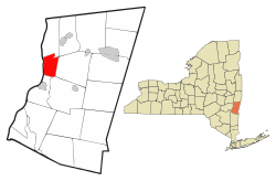 Location of Stockport, New York | |
| Coordinates: 42°18′37″N 73°44′59″W / 42.31028°N 73.74972°W | |
| Country | United States |
| State | New York |
| County | Columbia |
| Government | |
| • Type | Town Council |
| • Town Supervisor | Matt Murrell(R) |
| • Town Council |
Members' List
|
| Area | |
| • Total | 13.2 sq mi (34.1 km2) |
| • Land | 11.7 sq mi (30.2 km2) |
| • Water | 1.5 sq mi (3.9 km2) |
| Elevation | 131 ft (40 m) |
| Population (2010) | |
| • Total | 2,815 |
| • Density | 242/sq mi (93.3/km2) |
| Time zone | Eastern (EST) (UTC-5) |
| • Summer (DST) | EDT (UTC-4) |
| FIPS code | 36-71443 |
| GNIS feature ID | 0979529 |
| Website |
townofstockport |
Stockport is a town in Columbia County, New York, United States. The population was 2,815 at the 2010 census.[1]
Stockport is in the northwest part of the county, along the Hudson River.
History
The region was settled around 1657 and the The Staats House dates from this early period.
Stockport was created in 1833 from parts of the towns of Ghent and Stuyvesant and the city of Hudson. The Church of St. John the Evangelist was listed on the National Register of Historic Places in 1972.[2]
Geography
According to the United States Census Bureau, the town has a total area of 13.2 square miles (34.1 km2), of which 11.7 square miles (30.2 km2) is land and 1.5 square miles (3.9 km2), or 11.45%, is water.[1]
The west town line is defined by the center of the Hudson River, which marks the border of Greene County. Stockport Creek is a tributary of the Hudson that is formed near the center of the town by the junction of Kinderhook Creek and Claverack Creek.
Demographics
| Historical population | |||
|---|---|---|---|
| Census | Pop. | %± | |
| 1840 | 1,815 | — | |
| 1850 | 1,655 | −8.8% | |
| 1860 | 1,445 | −12.7% | |
| 1870 | 1,438 | −0.5% | |
| 1880 | 1,980 | 37.7% | |
| 1890 | 2,345 | 18.4% | |
| 1900 | 2,719 | 15.9% | |
| 1910 | 2,506 | −7.8% | |
| 1920 | 1,909 | −23.8% | |
| 1930 | 2,422 | 26.9% | |
| 1940 | 2,229 | −8.0% | |
| 1950 | 2,054 | −7.9% | |
| 1960 | 2,025 | −1.4% | |
| 1970 | 2,324 | 14.8% | |
| 1980 | 2,847 | 22.5% | |
| 1990 | 3,085 | 8.4% | |
| 2000 | 2,933 | −4.9% | |
| 2010 | 2,815 | −4.0% | |
| Est. 2014 | 2,750 | [3] | −2.3% |
As of the census[5] of 2000, there were 2,933 people, 1,116 households, and 805 families residing in the town. The population density was 251.9 people per square mile (97.3/km²). There were 1,204 housing units at an average density of 103.4 per square mile (39.9/km²). The racial makeup of the town was 96.49% White, 1.60% African American, 0.17% Native American, 0.10% Asian, 0.44% from other races, and 1.19% from two or more races. Hispanic or Latino of any race were 1.81% of the population.
There were 1,116 households out of which 34.4% had children under the age of 18 living with them, 55.6% were married couples living together, 11.4% had a female householder with no husband present, and 27.8% were non-families. 22.2% of all households were made up of individuals and 7.9% had someone living alone who was 65 years of age or older. The average household size was 2.62 and the average family size was 3.04.
In the town the population was spread out with 26.2% under the age of 18, 7.0% from 18 to 24, 30.2% from 25 to 44, 25.4% from 45 to 64, and 11.2% who were 65 years of age or older. The median age was 37 years. For every 100 females there were 96.6 males. For every 100 females age 18 and over, there were 96.8 males.
The median income for a household in the town was $42,107, and the median income for a family was $46,857. Males had a median income of $33,664 versus $25,959 for females. The per capita income for the town was $18,137. About 10.0% of families and 12.5% of the population were below the poverty line, including 22.4% of those under age 18 and 7.1% of those age 65 or over.
Communities and locations in Stockport
- Columbiaville – A hamlet near the geographic center of town, north of Stockport Creek on U.S. Route 9.
- Rossman – A hamlet northeast of Columbiaville by Kinderhook Creek.
- Stockport – The hamlet of Stockport is south of Stockport Creek on Route 9.
- Stottville – A hamlet near the south town line.
Stockport is served by two volunteer fire companies, the Stockport Volunteer Fire Co. No. 1[6] and the Stottville Volunteer Fire Co. No. 2.
Notable people
- Jasper Holmes (1900–1986), US Navy Intelligence Analyst
References
- 1 2 "Geographic Identifiers: 2010 Demographic Profile Data (G001): Stockport town, Columbia County, New York". U.S. Census Bureau, American Factfinder. Retrieved December 11, 2014.
- ↑ National Park Service (2009-03-13). "National Register Information System". National Register of Historic Places. National Park Service.
- ↑ "Annual Estimates of the Resident Population for Incorporated Places: April 1, 2010 to July 1, 2014". Retrieved June 4, 2015.
- ↑ "Census of Population and Housing". Census.gov. Archived from the original on May 11, 2015. Retrieved June 4, 2015.
- ↑ "American FactFinder". United States Census Bureau. Archived from the original on September 11, 2013. Retrieved 2008-01-31.
- ↑ http://www.ccnyfireapparatus.net/id44.html
External links
Coordinates: 42°18′34″N 73°44′46″W / 42.30944°N 73.74611°W
Municipalities and communities of Columbia County, New York, United States | ||
|---|---|---|
| City | 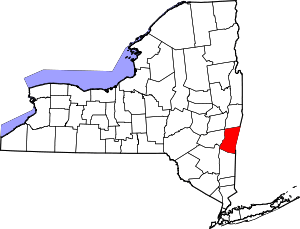 | |
| Towns | ||
| Villages | ||
| CDPs | ||
| Other hamlets | ||
| Footnotes | ‡This populated place also has portions in an adjacent county or counties | |