Chatham (village), New York
| Chatham, New York | |
|---|---|
| Village | |
|
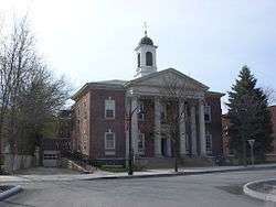
Tracy Memorial Village Hall, April 2009 | |
 Location of Chatham, New York | |
| Coordinates: 42°21′43″N 73°35′59″W / 42.36194°N 73.59972°WCoordinates: 42°21′43″N 73°35′59″W / 42.36194°N 73.59972°W | |
| Country | United States |
| State | New York |
| County | Columbia |
| Towns | Chatham, Ghent |
| Area | |
| • Total | 1.24 sq mi (3.21 km2) |
| • Land | 1.24 sq mi (3.20 km2) |
| • Water | 0.004 sq mi (0.01 km2) |
| Elevation | 463 ft (141 m) |
| Population (2010) | |
| • Total | 1,770 |
| • Density | 1,431/sq mi (552.5/km2) |
| Time zone | Eastern (EST) (UTC-5) |
| • Summer (DST) | EDT (UTC-4) |
| ZIP code | 12037 |
| Area code(s) | 518 Exchanges: 392,397 |
| FIPS code | 36-14003 |
| GNIS feature ID | 0946448 |
| Website |
villageofchatham |
Chatham /ˈtʃætəm/ is a village in Columbia County, New York, United States. The population was 1,770 at the 2010 census.[1]
The village of Chatham is in on the border between the towns of Chatham and Ghent. The village is at the junction of Routes 66 and 203.
History
The village was incorporated in 1869. Chatham was originally named Groats Corners. The village is the home of the 1814 Blinn-Pulver Farmhouse.
Chatham hosts a variety of attractions, such as the Crandell Theater, which shows many popular movies at very reasonable prices. The Mac-Hadyn Theater is a summer stock theater, active from May through September, that puts on Broadway-style shows. The famous stage and film actor Nathan Lane was part of their company at one time.
The Tracy Memorial Village Hall Complex and Union Station are listed on the National Register of Historic Places.[2]
Geography
Chatham is located at 42°21′43″N 73°35′58″W / 42.36194°N 73.59944°W (42.36207, -73.599686).[3] The northern half of the village, and the central business area, is in the town of Chatham, while the southern half is in the town of Ghent.
According to the United States Census Bureau, the village has a total area of 1.2 square miles (3.2 km2), of which 0.004 square miles (0.01 km2), or 0.34%, is water. The village is located on Stony Kill, a waterway that makes a U-shaped bend through the village and flows north to Kinderhook Creek, a tributary of the Hudson River.
Notable people
- George McClellan, US congressman
Demographics
| Historical population | |||
|---|---|---|---|
| Census | Pop. | %± | |
| 1870 | 1,387 | — | |
| 1880 | 1,765 | 27.3% | |
| 1890 | 1,912 | 8.3% | |
| 1900 | 2,018 | 5.5% | |
| 1910 | 2,251 | 11.5% | |
| 1920 | 2,710 | 20.4% | |
| 1930 | 2,424 | −10.6% | |
| 1940 | 2,254 | −7.0% | |
| 1950 | 2,304 | 2.2% | |
| 1960 | 2,426 | 5.3% | |
| 1970 | 2,239 | −7.7% | |
| 1980 | 2,001 | −10.6% | |
| 1990 | 1,920 | −4.0% | |
| 2000 | 1,758 | −8.4% | |
| 2010 | 1,770 | 0.7% | |
| Est. 2015 | 1,696 | [4] | −4.2% |
As of the census[6] of 2000, there were 1,758 people, 742 households, and 425 families residing in the village. The population density was 1,492.0 people per square mile (575.2/km²). There were 802 housing units at an average density of 680.7 per square mile (262.4/km²). The racial makeup of the village was 94.03% White, 3.07% Black or African American, 0.34% Native American, 0.40% Asian, 0.11% Pacific Islander, 0.17% from other races, and 1.88% from two or more races. Hispanic or Latino of any race were 1.65% of the population.
There were 742 households out of which 31.1% had children under the age of 18 living with them, 41.0% were married couples living together, 12.4% had a female householder with no husband present, and 42.7% were non-families. 37.6% of all households were made up of individuals and 14.4% had someone living alone who was 65 years of age or older. The average household size was 2.33 and the average family size was 3.06.
In the village the population was spread out with 26.1% under the age of 18, 6.8% from 18 to 24, 27.6% from 25 to 44, 24.6% from 45 to 64, and 15.0% who were 65 years of age or older. The median age was 38 years. For every 100 females there were 90.1 males. For every 100 females age 18 and over, there were 83.6 males.
The median income for a household in the village was $39,063, and the median income for a family was $44,500. Males had a median income of $32,083 versus $24,327 for females. The per capita income for the village was $19,476. About 6.7% of families and 8.4% of the population were below the poverty line, including 8.4% of those under age 18 and 10.7% of those age 65 or over.
As of the 2010 census, Chatham was 86.5% white, 5.0% Hispanic, 3.3% black, 2.4% Multiracial, 2.0% Asian, 0.3% Native American, 0.3 Other race, and 0.06% Native Hawaiian. [7]
Transportation

Chatham has only one traffic light; right turn on red is allowed at that intersection. It has 49 stop signs, 11 yield signs, and one traffic circle. In addition, there are 121 signs regulating parking.
Previous to the NYDOT renovations, cars driving in the traffic circle on Main Street yielded to cars entering the circle, which is an unusual traffic pattern. This pattern was changed to be in compliance with NY state traffic laws in 2008.
The village was a hub of the New York Central, Boston and Albany, and Rutland railroads, with three wyes and one roundhouse.
Events
- Columbia County Fair: Late August-Early September
- Fair Grounds Auto show: Spring/Late May
- Fair Ground 4 July Celebration (on the 4th of July)
- Civil War Reenactment: Summer
- Fire Fighters Parade: Part of Columbia County Fair
References
- ↑ "Geographic Identifiers: 2010 Demographic Profile Data (G001): Chatham village, New York". U.S. Census Bureau, American Factfinder. Retrieved December 11, 2014.
- ↑ "National Register of Historic Places Listings". Weekly List of Actions Taken on Properties: 1/04/16 through 1/08/16. National Park Service. 2016-01-15.
- ↑ "US Gazetteer files: 2010, 2000, and 1990". United States Census Bureau. 2011-02-12. Retrieved 2011-04-23.
- ↑ "Annual Estimates of the Resident Population for Incorporated Places: April 1, 2010 to July 1, 2015". Retrieved July 2, 2016.
- ↑ "Census of Population and Housing". Census.gov. Archived from the original on May 11, 2015. Retrieved June 4, 2015.
- ↑ "American FactFinder". United States Census Bureau. Archived from the original on 2013-09-11. Retrieved 2008-01-31.
- ↑ http://www.city-data.com/city/Chatham-New-York.html
External links
- Village of Chatham official website
- Chatham Area Business Alliance
- Crandell Theatre, the oldest and largest movie theater in Columbia County, built in 1926 on Main Street
Municipalities and communities of Columbia County, New York, United States | ||
|---|---|---|
| City | 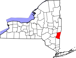 | |
| Towns | ||
| Villages | ||
| CDPs | ||
| Other hamlets | ||
| Footnotes | ‡This populated place also has portions in an adjacent county or counties | |