Gallatin, New York
| Gallatin, New York | |
|---|---|
| Town | |
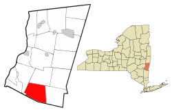 Location of Gallatin, New York | |
| Coordinates: 42°3′56″N 73°42′59″W / 42.06556°N 73.71639°WCoordinates: 42°3′56″N 73°42′59″W / 42.06556°N 73.71639°W | |
| Country | United States |
| State | New York |
| County | Columbia |
| Government | |
| • Type | Town Council |
| • Town Supervisor | John Reilly |
| • Town Council |
Members' List
|
| Area | |
| • Total | 39.6 sq mi (102.6 km2) |
| • Land | 39.1 sq mi (101.3 km2) |
| • Water | 0.5 sq mi (1.3 km2) |
| Elevation | 1,063 ft (324 m) |
| Population (2010) | |
| • Total | 1,668 |
| • Density | 43/sq mi (16.5/km2) |
| Time zone | Eastern (EST) (UTC-5) |
| • Summer (DST) | EDT (UTC-4) |
| FIPS code | 36-28068 |
| GNIS feature ID | 0978984 |
| Website |
gallatin-ny |
Gallatin is a town in Columbia County, New York, United States. The population was 1,668 at the 2010 census.[1] Gallatin is on the south border of Columbia County and located 100 miles (160 km) north of New York City.
History
The region was part of Livingston Manor. The town was formed in 1830 from part of the town of Ancram. It is named for Albert Gallatin.[2]
Geography
According to the United States Census Bureau, the town has a total area of 39.6 square miles (102.6 km2), of which 39.1 square miles (101.3 km2) is land and 0.50 square miles (1.3 km2), or 1.31%, is water.[1] Most of the town drains to the Roeliff Jansen Kill, a tributary of the Hudson River. A small portion of the northeast corner of town drains via Suydam Creek to Taghkanic Creek, then via Claverack Creek to the Hudson River north of the city of Hudson.
The south town line is the border of Dutchess County.
The Taconic State Parkway crosses the town.
Demographics
| Historical population | |||
|---|---|---|---|
| Census | Pop. | %± | |
| 1830 | 1,588 | — | |
| 1840 | 1,644 | 3.5% | |
| 1850 | 1,586 | −3.5% | |
| 1860 | 1,533 | −3.3% | |
| 1870 | 1,416 | −7.6% | |
| 1880 | 1,252 | −11.6% | |
| 1890 | 1,016 | −18.8% | |
| 1900 | 823 | −19.0% | |
| 1910 | 720 | −12.5% | |
| 1920 | 633 | −12.1% | |
| 1930 | 511 | −19.3% | |
| 1940 | 554 | 8.4% | |
| 1950 | 613 | 10.6% | |
| 1960 | 621 | 1.3% | |
| 1970 | 737 | 18.7% | |
| 1980 | 1,292 | 75.3% | |
| 1990 | 1,658 | 28.3% | |
| 2000 | 1,499 | −9.6% | |
| 2010 | 1,668 | 11.3% | |
| Est. 2014 | 1,648 | [3] | −1.2% |
As of the census[5] of 2000, there were 1,499 people, 609 households, and 414 families residing in the town. The population density was 38.2 people per square mile (14.7/km²). There were 913 housing units at an average density of 23.3 per square mile (9.0/km²). The racial makeup of the town was 97.60% White, 0.47% African American, 0.20% Native American, 0.73% Asian, 0.40% from other races, and 0.60% from two or more races. Hispanic or Latino of any race were 2.20% of the population.
There were 609 households out of which 29.9% had children under the age of 18 living with them, 57.1% were married couples living together, 6.1% had a female householder with no husband present, and 32.0% were non-families. 25.9% of all households were made up of individuals and 10.8% had someone living alone who was 65 years of age or older. The average household size was 2.45 and the average family size was 2.99.
In the town the population was spread out with 23.1% under the age of 18, 5.4% from 18 to 24, 28.0% from 25 to 44, 28.1% from 45 to 64, and 15.4% who were 65 years of age or older. The median age was 42 years. For every 100 females there were 103.7 males. For every 100 females age 18 and over, there were 103.7 males.
The median income for a household in the town was $42,454, and the median income for a family was $48,393. Males had a median income of $35,500 versus $23,375 for females. The per capita income for the town was $21,041. About 2.9% of families and 5.6% of the population were below the poverty line, including 3.5% of those under age 18 and 9.9% of those age 65 or over.
Communities and location in Gallatin
- Elizaville – A hamlet at the west town line.
- Gallatinville – A hamlet in the eastern part of town on County Road 7.
- Jacksons Corners – A location at the south town line near the Taconic Parkway.
- Lake Taghkanic State Park – Surrounding Lake Taghkanic near the northern town line.
- Mount Ross – A hamlet at the town line on the Roeliff Jansen Kill.
- Silvernails – A hamlet south of Gallatinville.
- Snyderville – A hamlet in the northwest part of the town. The William and Victoria Pulver House and Snyderville Schoolhouse are listed on the National Register of Historic Places.[6]
- Spaulding Furnace – A hamlet southwest of Gallatinville.
References
- 1 2 "Geographic Identifiers: 2010 Demographic Profile Data (G001): Gallatin town, Columbia County, New York". U.S. Census Bureau, American Factfinder. Retrieved December 9, 2014.
- ↑ Gannett, Henry (1905). The Origin of Certain Place Names in the United States. Govt. Print. Off. p. 133.
- ↑ "Annual Estimates of the Resident Population for Incorporated Places: April 1, 2010 to July 1, 2014". Retrieved June 4, 2015.
- ↑ "Census of Population and Housing". Census.gov. Retrieved June 4, 2015.
- ↑ "American FactFinder". United States Census Bureau. Retrieved 2008-01-31.
- ↑ National Park Service (2010-07-09). "National Register Information System". National Register of Historic Places. National Park Service.
External links
- Town of Gallatin official website
- Lake Taghkanic State Park
- Lake Taghkanic State Park information
- Historical information about Gallatin
Municipalities and communities of Columbia County, New York, United States | ||
|---|---|---|
| City | 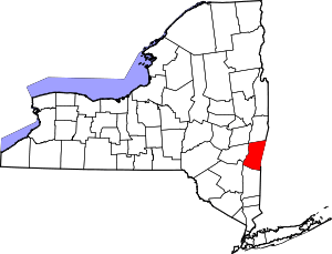 | |
| Towns | ||
| Villages | ||
| CDPs | ||
| Other hamlets | ||
| Footnotes | ‡This populated place also has portions in an adjacent county or counties | |