Spratly Islands dispute
| Part of a series on the |
| Spratly Islands |
|---|
 Spratly Islands military occupations map |
| Related articles |
| Confrontations |
| Military occupations |
|
|
The Spratly Islands dispute is an ongoing territorial dispute between Brunei, China (People's Republic of China), Malaysia, the Philippines, Taiwan, and Vietnam, concerning ownership of the Spratly Islands, a group of islands and associated "maritime features" (reefs, banks, cays, etc.) located in the South China Sea. The dispute is characterised by diplomatic stalemate and the employment of military pressure techniques (such as military occupation of disputed territory) in the advancement of national territorial claims. All except Brunei occupy some of the maritime features.
There has been a sharp rise in media coverage owing mainly to China's increasingly vocal objection to the presence of American naval vessels transiting the area in order to assert the right to freedom of navigation within international waters.
Most of the "maritime features" in this area have at least six names: The "International name", usually in English; the "Chinese name", sometimes different for PRC and ROC, (and also in different character-sets); the Vietnamese, Philippine and Malaysian names, and also, there are alternate names, (e.g. Spratly Island is also known as Storm Island), and sometimes names with "colonial" origins (French, Portuguese, Spanish, British, etc.).[1]
The Spratly Islands are important for economic and strategic reasons. The Spratly area holds potentially significant, but largely unexplored, reserves of oil and natural gas; it is a productive area for world fishing; it is one of the busiest areas of commercial shipping traffic; and surrounding countries would get an extended continental shelf if their claims were recognised. In addition to economic incentives, the Spratlys sit astride major maritime trade routes to Northeast Asia, giving them added significance as positions from which to monitor maritime activity in the South China Sea and to potentially base and project military force from. In 2014, China drew increased international attention due to its dredging activities within the Spratlys, amidst speculation it is planning to further develop its military presence in the area.[2] In 2015 satellite imagery revealed that China was rapidly constructing an airfield on Fiery Cross Reef within the Spratlys whilst continuing its land reclamation activities at other sites.[3][4][5] Only China (PRC), Taiwan (ROC), and Vietnam have made claims based on historical sovereignty of the islands.[6] The Philippines, however, claims part of the area as its territory under UNCLOS, an agreement parts of which[7] have been ratified by the countries involved in the Spratly islands dispute.
Reasons for the dispute
There are multiple reasons why the neighbouring nations in particular, and the rest of the world in general, would be interested in the Spratly Islands.
Hydrocarbons
In 1968, oil was discovered in the region.[8] The Geology and Mineral Resources Ministry of the People's Republic of China (PRC) has estimated that the Spratly area holds oil and natural gas reserves of 17.7 billion tons (1.60 × 10¹⁰ kg), compared to the 13 billion tons (1.17 × 10¹⁰ kg) held by Kuwait, placing it as, potentially, the fourth largest reserve bed in the world. The United States Energy Information Administration contests this, estimating almost no oil and less than 100 billion cubic feet of natural gas exists in fields near the Spratly Islands.[9][10] Still, these large potential reserves have assisted in intensifying the territorial claims of the neighbouring countries.
In 1968 and 1970, the Philippines started to take their territorial claims more seriously and stationed troops on three islands which had been claimed by the adventurer Tomas Cloma as part of Freedomland.[11] In 1973, Vietnamese troops were stationed on five islands.[12]
On 11 March 1976, the first major Philippine oil discovery occurred off the coast of Palawan, near the Spratly Islands territory. In 2010, these oil fields supplied 15% of all petroleum consumed in the Philippines.[13] In 1992, the PRC and Vietnam granted oil exploration contracts to US oil companies that covered overlapping areas in the Spratlys. In May 1992,[14] the China National Offshore Oil Corporation (CNOOC) and Crestone Energy (a US company based in Denver, Colorado) signed a co-operation contract for the joint exploration of the Wan'an Bei-21 block, a 25,155 square kilometres (9,710 sq mi) section of the southwestern South China Sea that includes Spratly Island areas.[15] Part of the Crestone's contract covered Vietnam's blocks 133 and 134, where PetroVietnam, PetroStar Energy(USA) and ConocoPhillips Vietnam Exploration & Production, a unit of ConocoPhillips, agreed to evaluate prospects in April 1992. This led to a confrontation between China and Vietnam, with each demanding that the other cancel its contract.
Commercial fishing
The region is one of the world's most productive areas for commercial fishing. In 2010, the Western Central Pacific (excluding the northernmost reaches of the South China Sea closest to the PRC coast) accounted for 14% of the total world catch at 11.7 million tonnes. This was up from less than 4 million tonnes in 1970.[16] The PRC has predicted that the South China Sea holds combined fishing and oil and gas resources worth one trillion dollars. There have already been numerous clashes between the PRC and the Philippines, PRC and Vietnam, and between other nations over "foreign" fishing vessels in Exclusive Economic Zones (EEZs), and the media regularly report the arrest of Chinese fishermen. In 1984, Brunei established an exclusive fishing zone encompassing Louisa Reef in the southeastern Spratly Islands.[17]
Commercial shipping
The region is one of the busiest shipping lanes in the world. During the 1980s, at least 270 ships passed through the Spratly Islands region each day. More than half of the world's supertanker traffic, by tonnage, passes through the region's waters every year. Tanker traffic through the South China Sea is over three times greater than through the Suez Canal and five times more than through the Panama Canal; 25% of the world's crude oil passes through the South China Sea.
Confrontations
There have been a number of notable clashes in the Spratly Islands, some of which are discussed in the following articles:
- Territorial disputes in the South China Sea
- Southwest Cay Invasion/Southwest Cay invasion (1975)
- Johnson South Reef Skirmish (14 March 1988)
- Scarborough Shoal standoff (commenced 8 April 2012)
International law
Extended continental shelf claims, 2009
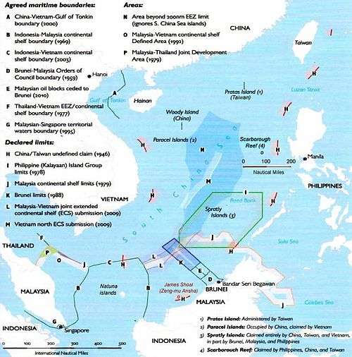
Via UNCLOS, the United Nations provided for countries with coastlines to submit claims to the UN's Commission on the Limits of the Continental Shelf (CLCS),[18] (for their continental shelf to be extended beyond 200 nautical miles of their shores), by 13 May 2009. A total of 48 nations made full claims, and dozens more made preliminary submissions.[19] Two of the submissions made to the CLCS addressed claims in the South China Sea (SCS) – one by Vietnam for a claim over the northern portion of the SCS (which included the Paracel Islands), and another jointly by Vietnam and Malaysia for a joint claim over a "defined area" in the middle of the SCS between the two countries, which included part of the Spratly Islands. Brunei made a preliminary submission notifying of its intention to claim a continental shelf beyond 200 nautical miles from its shores.[20]
China (PRC) immediately issued protests over the two submissions and called on the United Nations not to consider them. It also issued a stern warning to countries not to claim the islands which it said were its sovereign territory.[19][21]
Philippine protests to ITLOS, 2011
On 23 May 2011, Philippine President Benigno Aquino III warned the visiting Chinese Defense Minister Liang Guanglie of a possible arms race in the region if tensions worsened over disputes in the South China Sea. In March, the Philippines complained that Chinese patrol boats had harassed a Philippine oil exploration vessel in disputed waters near the Spratlys, and subsequently filed a formal protest at the International Tribunal for the Law of the Sea (ITLOS).[22]
Philippines submission to the Permanent Court of Arbitration, 2013-2016
On 22 January 2013, the Philippines instituted arbitral proceedings against the People's Republic of China in the Permanent Court of Arbitration (PCA).[23][24] On 19 February 2013, China rejected and returned the Philippines' Notification. The Permanent Court of Arbitration acts as Registry in this arbitration.[24]
Philippine Justice Antonio T. Carpio states that the case is solely a maritime dispute, and not territorial in nature. The Philippines seeks clarification from the tribunal as to whether China's 9-dashed line can negate the Philippines' Exclusive Economic Zone as guaranteed under the United Nations Convention on the Law of the Sea (UNCLOS), of which China is a signatory. As part of the case, the Philippines also seeks clarification on whether rocks above water only at high tide, (such as Scarborough Shoal), generate a 200-nautical-mile (370 km; 230 mi) EEZ, or only a 12-nautical-mile (22 km; 14 mi) territorial sea. Clarification of whether China can appropriate low-tide elevations, such as the Mischief Reef and the Subi Reef within the Philippines' EEZ, have also been included in the case. "The Philippines is not asking the tribunal to delimit by nautical measurements overlapping EEZs between China and the Philippines. The Philippines is also not asking the tribunal what country has sovereignty over an island, or rock above water at high tide, in the West Philippine Sea."[25]
According to a PCA press release on 12 July 2016 "[The] Tribunal concluded that, as between the Philippines and China, there was no legal basis for China to claim historic rights to resources, in excess of the rights provided for by the Convention, within the sea areas falling within the ‘nine-dash line’," [26]
Diplomatic moves
1992 ASEAN Declaration on the South China Sea
On 22 July 1992, ASEAN issued a declaration on the South China Sea, emphasising that the dispute should be solved peacefully without resorting to violence.[27]
1995 Agreement
Following a 1995 dispute between the PRC and the Philippines, an ASEAN-brokered agreement was reached between the PRC and ASEAN member nations whereby one country would inform the other of any military movement within the disputed territory, and that there would be no further construction.
The agreement was promptly violated by PRC and Malaysia: claiming storm damage, seven PLA Navy vessels entered the area to repair "fishing shelters" in Panganiban Reef (Mischief Reef); Malaysia erected a structure on Investigator Shoal and landed at Rizal Reef (Commodore Reef). In response, the Philippines lodged formal protests, demanded the removal of the structures, increased naval patrols in Kalayaan, and issued invitations to American politicians to inspect the PRC bases by plane.
Declaration on the Conduct of Parties in the South China Sea, 2002
On 4 November 2002 in Phnom Penh, the Declaration on the Conduct of Parties in the South China Sea[28] was signed by the 10 foreign ministers of ASEAN countries and China (PRC). The parties explicitly undertook in this declaration, "to resolve their territorial and jurisdictional disputes by peaceful means, without resorting to the threat or use of force, through friendly consultations and negotiations by sovereign states directly concerned".[28] The parties also undertook to exercise self-restraint with activities that would complicate or escalate disputes and affect peace and stability, including refraining from inhabiting the presently uninhabited islands, reefs, shoals, cays, and other features. The parties pledged to carry out confidence building measures, such as: holding dialogues and exchange of views as appropriate between their defence and military officials; ensuring just and humane treatment of all persons who are in danger or distress; notifying on a voluntary basis other parties concerned of any impending joint / combined military exercise; and exchanging, on a voluntary basis, relevant information. The parties may also explore or undertake cooperative activities such as: marine environmental protection; marine scientific research; safety of navigation and communication at sea; search and rescue operations; and combating transnational crime, including but not limited to trafficking in illicit drugs, piracy, armed robbery at sea, and illegal traffic in arms.
The declaration eases tensions, but falls short of a legally binding code of conduct.
Code of Conduct in the South China Sea
In July 2012, China (PRC) announced that it is open to launching discussions on the Code of Conduct in the South China Sea, but called for all parties to exercise self-restraint in keeping with the spirit of previous declarations and United Nation conventions. This announcement has been criticised by many neighbouring states because of the contradictions seen in the Scarborough Shoal at that time where China has established de facto control.[29]
On 2 August 2012, the United States Senate unanimously passed a resolution declaring that China's July 2012 actions to unilaterally assert control of disputed territories in the South China Sea "are contrary to agreed upon principles with regard to resolving disputes and impede a peaceful resolution."[30]
Chinese dredging activities
In 2014 Janes reported that during 2013–2014 China had begun a substantial program of dredging and land reclamation at three sites in the Spratlys. Janes concluded that 'The strategic effect of China's dredging and land reclamation makes it the most significant change to the South China Sea dispute since the 1988 Battle of Johnson South Reef. If completed as envisioned in the CGI designs, China will have its first airstrip in the Spratly islands – and a base from which to impose its interpretation of the surrounding features' sovereignty'.[2]
Janes also noted that in contrast to the previous construction projections of other countries in the Spratlys, 'The main difference between these activities and China's is that they modified existing land masses, while Beijing is constructing islands out of reefs that for the most part were under water at high tide'.
There is no known official term for the projects; the phrase "great wall of sand" was first used by Harry Harris, commander of the US Pacific Fleet, in March 2015.[31]
2015 construction of an airfield at Fiery Cross Reef
In April 2015 new satellite imagery revealed that China was rapidly constructing an airfield at Fiery Cross Reef, in addition to its ongoing dredging activities in the Spratlys.[4] In September, China had completed a 3125-metre runway.[32]
Claims and their basis

Brunei
Brunei claims the part of the South China Seas nearest to it as part of its continental shelf and Exclusive Economic Zone (EEZ). In 1984, Brunei declared an EEZ encompassing the above-water islets it claims in Louisa Reef.[17][33] Brunei does not practice military control in the area.
Basis of Brunei's claim
Brunei's claims to the reef are based on the United Nations Convention on the Law of the Sea (UNCLOS).[34][35] Brunei states that the southern part of the Spratly Islands chain is actually a part of its continental shelf, and therefore a part of its territory and resources.[36]
Malaysia
Malaysia claims a small number of islands in the Spratly Islands and its claims cover only the islands included in its Exclusive economic zone of 200 miles as defined by the United Nations Convention on the Law of the Sea. Malaysia has militarily occupied three islands that it considers to be within its continental shelf. Swallow Reef (Layang Layang / Terumbu Layang / Pulau Layang Layang) was under control on 1983 and has been turned into an island through a land reclamation which now also hosts a dive resort.[37] The Malaysian military also occupies Ardasier Reef (Terumbu Ubi), and Mariveles Reef (Terumbu Mantanani).[33]
Basis of Malaysia's claim
Malaysia's claims are based upon the continental shelf principle, and have clearly defined coordinates within the limits of its EEZ defined in 1979.[37][38] This argument requires that the islands were res nullius and this requirement is said to be satisfied as when Japan renounced their sovereignty over the islands according to the San Francisco Treaty, there was a relinquishment of the right to the islands without any special beneficiary. Therefore, the islands became res nullius and available for annexation.[33][39]
China, the Republic of China, and the People's Republic of China
The People's Republic of China (PRC) claims all of the Spratly Islands as part of China based on UNCLOS and history.[40]
The Republic of China (ROC), which ruled mainland China before 1949 and has been confined to Taiwan since 1949, also claims all of the Spratly Islands.
Basis for PRC's and ROC's claims
China claims to have discovered the islands in the Han dynasty in 2 BC. The islands were claimed to have been marked on maps compiled during the time of Eastern Han dynasty and Eastern Wu (one of the Three Kingdoms). Since the Yuan dynasty in the 12th century, several islands that may be the Spratlys have been labelled as Chinese territory,[41] followed by the Ming dynasty[42] and the Qing dynasty from the 13th to 19th Century;[43] the islands may have appeared on a 1755 map, among others.[43][44] Archaeological surveys have found the remains of Chinese pottery and coins in the islands, cited as proof for the PRC claim, but they are more likely to have come from shipwrecks of passing Chinese junks.[45]
Chinese fishermen have fished around the islands since 200 BC.[46]
In the 19th century, Europeans found that Chinese fishermen from Hainan annually sojourned on the Spratly islands for part of the year, while in 1877 it was the British who launched the first modern legal claims to the Spratlys.[47][48]
When the Spratlys and Paracels were being surveyed by Germany in 1883, China issued protests against them. China sent naval forces on inspection tours in 1902 and 1907 and placed flags and markers on the islands. The Qing dynasty's successor state, the Republic of China, claimed the Spratly and Paracel islands under the jurisdiction of Hainan.[49]
The Spratlys and the Paracels were conquered by Japan in 1939. Japan administered the Spratlys via Taiwan's jurisdiction and the Paracels via Hainan's jurisdiction.[47] The Paracels and Spratlys were handed over to Republic of China control from Japan after the 1945 surrender of Japan,[50] since the Allied powers assigned the Republic of China to receive Japanese surrenders in that area.[49]
After WW2 ended, the Republic of China was the "most active claimaint". The Republic of China then garrisoned Itu Aba (Taiping) island in 1946 and posted Chinese flags and markers on it along with Woody island in the Paracels, France tried, but failed to make them leave Woody island.[47] The aim of the Republic of China was to block the French claims.[49][51] The Republic of China drew up the map showing the U shaped claim on the entire South China Sea, showing the Spratly and Paracels in Chinese territory, in 1947.[49]
Taiwan's garrison from 1946–1950 and 1956-now on Itu Aba represents an "effective occupation" of the Spratly islands.[52][53]
Taiwan garrison forces actively fended off Philippine efforts to build on the Spratly before 1971. After the UN vote to recognize the PRC, the ROC government in Taiwan no longer was in position to defends it rights. The Philippines and Vietnam took this opportunity to establish outposts in the Spratlys.
Japanese scholar Taoka Shunji criticised Japanese Prime Minister Shinzo Abe for trying to falsely portray China as a threat to Japan and that it was invading its neighbours like the Philippines, and pointed out that the Spratly islands were not part of the Philippines when the US acquired the Philippines from Spain in the Treaty of Paris in 1898, and the Japanese ruled Taiwan itself had annexed the Spratly islands in 1938 and the US ruled Philippines did not challenge the move and never asserted that it was their territory, he also pointed out that other countries did not need to do full land reclamation since they already control islands and that the reason China engaged in extensive land reclamation is because they needed it to build airfields since China only has control over reefs.[54]
The Philippines
_-_Geographicus_-_EastIndies-cary-1801.jpg)
The Philippines' claims are based on sovereignty over the Spratlys on the issues of Res nullius and geography. The Philippines contend their claim was Res nullius as there was no effective sovereignty over the islands until the 1930s when France and then Japan acquired the islands. When Japan renounced their sovereignty over the islands according to the San Francisco Treaty, there was a relinquishment of the right to the islands without any special beneficiary. Therefore, the islands became Res nullius and available for annexation, according to the claim.
In 1956, a private Filipino citizen, Tomás Cloma, unilaterally declared a state on 53 features in the South China Sea, calling it "Freedomland". The Republic of China moved to occupy the main island in response. In December 1974, Cloma was arrested and forced to sign a document to convey to the Philippines whatever rights he might have had in the territory for one peso.[55] Cloma sold his claim to the Philippine government, which annexed (de jure) the islands in 1978, calling them Kalayaan. On 11 June 1978, President Ferdinand Marcos of the Philippines issued Presidential decree No. 1596, declaring the Spratly Islands (referred to therein as the Kalayaan Island Group) as Philippine territory.[56]
The Philippine claim to Kalayaan on a geographical basis can be summarised using the assertion that Kalayaan is distinct from other island groups in the South China Sea, because of the size of the biggest island in the Kalayaan group. A second argument used by the Philippines regarding their geographical claim over the Spratlys is that all the islands claimed by the Philippines lie within its 200-mile Exclusive Economic Zone according to the 1982 United Nations Convention on the Law of the Sea. This argument assumes that the islands were res nullius.[57] The Philippines also contend, under maritime law that the People's Republic of China can not extend its baseline claims to the Spratlys because the PRC is not an archipelagic state.
Vietnam

On the 25 July 1994, Vietnam ratified the UNCLOS. Upon ratification it declared:
The National Assembly reiterates Viet Nam's sovereignty over the Hoang Sa and Truong Sa archipelagoes and its position to settle those disputes relating to territorial claims as well as other disputes in the Eastern Sea through peaceful negotiations in the spirit of equality, mutual respect and understanding, and with due respect of international law, particularly the 1982 United Nations Convention on the Law of the Sea, and of the sovereign rights and jurisdiction of the coastal States over their respective continental shelves and exclusive economic zones[58]
Vietnam's response to China's claim is that Chinese records on Qianli Changsha and Wanli Shitang are in fact records about non-Chinese territories.[59] For example, Qianli Changsha and Wanli Shitang were referred to in the ancient Chinese texts Ling Wai Dai Da[60] and Zhu Fan Zhi[61] as being in the Sea of Jiaozhi, Jiaozhi being the old name for a Chinese province in modern-day northern Vietnam, or as writings on foreign countries.
Vietnam's view is that the Chinese records do not constitute the declaration and exercise of sovereignty and that China did not declare sovereignty over the Spratlys until after World War II.
On the other hand, Vietnam claims the Spratlys based on international law on declaring and exercising sovereignty.
Vietnamese claims that it has occupied the Spratly and the Paracel islands at least since the 17th century, when they were not under the sovereignty of any state, and that they exercised sovereignty over the two archipelagos continuously and peacefully until they were invaded by Chinese armed forces.[62] In Phủ biên tạp lục (撫邊雜錄, Miscellaneous Records of Pacification in the Border Area) by the scholar Lê Quý Đôn, Hoàng Sa (Paracel Islands), and Trường Sa (Spratly Islands) were defined as belonging to Quảng Ngãi District. In Đại Nam nhất thống toàn đồ (大南ー統全圖), an atlas of Vietnam completed in 1838, Trường Sa was shown as Vietnamese territory.[63] Vietnam had conducted many geographical and resource surveys of the islands.[63] The results of these surveys have been recorded in Vietnamese literature and history published since the 17th century. After the treaty signed with the Nguyễn dynasty, France represented Vietnam in international affairs and exercised sovereignty over the islands.[63]
The Cairo Declaration, drafted by the Allies and China towards the end of World War II, listed the territories that the Allies intended to strip from Japan and return to China. Despite China being among the authors of the declaration, this list did not include the Spratlys.[64] Vietnam's response to China's claim that the Cairo Declaration somehow recognised the latter's sovereignty over the Spratlys is that this claim has no basis in fact.
At the San Francisco Conference on the peace treaty with Japan, the Soviet Union proposed that the Paracels and Spratlys be recognised as belonging to China. This proposal was rejected by an overwhelming majority of the delegates. On 7 July 1951, Tran Van Huu, head of the Bảo Đại Government's (State of Vietnam) delegation to the conference declared that the Paracels and Spratlys were part of Vietnamese territory. This declaration met with no challenge from the 51 representatives at the conference.[63]
The text of the Treaty of San Francisco did not list the Spratlys, or any other island territories, to be returned to China.[65]
The Geneva Accords, which China was a signatory, settled the First Indochina War end. French Indochina was split into three countries: Laos, Cambodia, and Vietnam. Vietnam was to be temporarily divided along the 17th Parallel.
Chapter I, Article 4 states:
The provisional military demarcation line between the two final regrouping zones is extended into the territorial waters by a line perpendicular to the general line of the coast. All coastal islands north of this boundary shall be evacuated by the armed forces of the French Union, and all islands south of it shall be evacuated by the forces of the People's Army of Viet-Nam.[66]
On October 26, 1955, the Republic of Vietnam "South Vietnam" replaced the State of Vietnam (part of the French Union) and inherit of its rights. The Vietnamese government's Vietnam United Youth League, which runs the newspaper Thanh Niên News, claims that although, nothing was said explicitly about offshore archipelagos, which was of small interest by that times, it was clearly understood by all the parties that the Republic of Vietnam inherit of all the French Indochina's Vietnamese territories under the 17th Parallel. As the Paracel and the Spratly archipelagos (which lay below the 17th parallel) were part of the French Indochina since 1933, they were part of “South Vietnam” territory. The French bestowed its titles, rights, and claims over the two island chains to the Republic of Vietnam.[67]
The Republic of Vietnam (RVN) exercised sovereignty over the islands, by placing border markers on the Spratlys to indicate South Vietnamese sovereignty over the archipelago. Up to the end of the Vietnam War the Republic of Vietnam Navy held military control over the majority of the Spratly Islands until 1975, when North Vietnamese troops attacked South Vietnamese troops and occupied the islands. After the Vietnam War, the unified Vietnam SRV (Socialist Republic of Vietnam) continued to claim the Spratly islands as an indisputably integral part of Vietnam.

China has produced a letter written by North Vietnam’s former Prime Minister Phạm Văn Đồng in 1958 as proof that it holds sovereignty over the Paracel and Spratly islands. The Vietnamese newspaper Thanh Niên News claims China has intentionally misrepresented the letter, which contains no direct reference to either island chain. In addition, it ignores the spirit and time in which the letter was written. During that time, the two communist neighbors shared extremely close ties and the US navy was patrolling the Taiwan Strait, threatened them both. The letter represented a diplomatic gesture of goodwill that has no legal relevance to the current territorial dispute, stating:[67]
| Original | English |
|---|---|
|
|
On September 4, 1958, with the seventh fleet of the US Navy patrolling the Taiwan Straight, China announced its decision to extend the breadth of its territorial waters to 12 nautical miles. The United Nations (to which China was not yet a member) had just held its first Conference on the Law of the Sea in Switzerland in 1956, and the resulting treaties, including the Convention on the Territorial Sea and the Contiguous Zone, were signed in 1958. Though the UN conference was considered a success, it left the exact breadth of each nation's territorial waters somewhat unresolved; the US, for instance, said it should extend just three nautical miles.[67]
On September 14, 1958, North Vietnam’s PM Phạm Văn Đồng wrote his letter to PM Zhou Enlai in response to China’s declaration. The Vietnamese newspaper Thanh Nien News claims that the letter has no legal relevance in China’s sovereignty claims to the Paracel and Spratly archipelagos for the three following reasons:
- Point 1: The Democratic Republic of Vietnam (North Vietnam) was not in control of the Paracel and the Spratly archipelagos at the time PM Dong wrote his letter.
- Point 2: The Constitutions of 1946 and 1957 of the Democratic Republic of Vietnam stipulated that territorial transfers must be decided by an act of parliament, the most powerful body in the country. As such, the Prime Minister had no right to relinquish the islands.
- Point 3: PM Pham Van Dong’s letter is a unilateral declaration written solely as a response to China's declaration on a 12 nautical mile territorial waters. The letter makes no mention, whatsoever, of territorial sovereignty over any archipelago.[67]
The islands occupied by Vietnam are organised as a district of Khánh Hòa Province. According to the 2009 census, the Trường Sa District has a population of 195 people.[68] At the 12th National Assembly (2007–2011) Election held early in Trường Sa, the people and soldiers also voted for their local district government for the first time. For the first time, Trường Sa is organised like a normal inland district, with a township (Trường Sa) and two communes (Sinh Tồn and Song Tử Tây). Forty nine people were elected to the communes' people's councils. In July 2012 the National Assembly of Vietnam passed a law demarcating Vietnamese sea borders to include the Spratly and Paracel Islands.[69][70]
Champa historically had a large presence in the South China Sea. The Vietnamese broke Champa's power in an invasion of Champa in 1471, and then finally conquered the last remnants of the Cham people in a war in 1832.[71] The Vietnamese government fears that using the evidence of Champa's historical connection to the disputed islands in South China Sea would expose the human rights violations and killings of ethnic minorities in Vietnam such as in the 2001 and 2004 uprisings, and lead to the issue of Cham autonomy being brought to attention.[72]
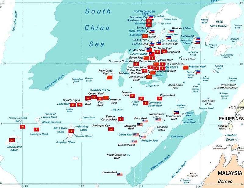
Tabular listing of features showing country possessions
Timeline
| 19th century– | Europeans found that Chinese fishermen from Hainan annually sojourned on the Spratly islands for part of the year.[47][48] |
| 1870– | British naval captain James George Meads established the micronation The Republic of Morac-Songhrati-Meads. |
| 1883– | When the Spratlys and Paracels were being surveyed by Germany in 1883, China issued protests against them.[46] |
| 1887– | The 1887 Chinese-Vietnamese Boundary convention signed between France and China after the Sino-French War said that China was the owner of the Spratly and Paracel islands.[46] |
| 1900– | Colonial French Indochina asserted that the state Bac Hai Company had exercised Vietnam's sovereignty in the Spratlys since the 18th century.[73] |
| 1927 | The French ship SS De Lanessan conducted a scientific survey of the Spratly Islands. |
| 1930 | France launched a second expedition with the La Malicieuse, which raised the French flag on an island called Île de la Tempête. Chinese fishermen were present on the island, but the French made no attempt to expel them. |
| 1933 | Three French ships took control of nine of the largest islands and declared French sovereignty over the archipelago to the great powers including the UK, US, China and Japan, according to the principles found in the Berlin convention. France administered the area as part of Cochinchina.
Japanese companies applied to the French authority in Cochichina for phosphate mining licenses in the Spratlys. |
| 1939 | The Empire of Japan disputed French sovereignty over the islands, citing that Japan was the first country to discover the islands. Japan declared its intention to place the island group under its jurisdiction. France and the United Kingdom protested and reasserted French sovereignty claims. |
| 1941 | Japan forcibly occupied the island group and remained in control until the end of World War II, administering the area as part of Taiwan.
A Japanese submarine base was established on Itu Aba Island. |
| 1945 | After Japan's surrender at the end of World War II, the Republic of China claimed the Paracel and Spratly Islands. The Republic of China sent troops to Itu Aba Island; forces erected sovereignty markers and named it Taiping Island. |
| 1946 | France dispatched warships to the islands several times, but no attempts were made to evict Chinese forces. |
| 1947 | China produced a map with 9 undefined dotted lines, and claimed all of the islands within those lines.[74] France demanded the Chinese withdraw from the islands. |
| 1948 | France ceased maritime patrols near the islands and China withdrew most of its troops. |
| 1951 | At the 1951 San Francisco Conference on the Peace Treaty with Japan, the Soviet Union proposed that the Spratlys belonged to China. This was overwhelmingly rejected by the delegates. The delegates from Vietnam, which at that time was a French protectorate, declared sovereignty over the Paracel and the Spratly Islands, which was not opposed by any delegate at the conference. China did not attend the conference and was not a signatory of the treaty. |
| 1956 | On June 15, 1956, Vice-Foreign Minister Un Van Khiem of the Democratic Republic of Vietnam received Li Zhimin, Chare d'Affaires ad interim of the Chinese Embassy in Vietnam, and told him that, "according to Vietnamese data, the Xisha and Nansha Islands are historically part of Chinese territory." Le Loc, Acting Director of the Asian Department of the Vietnamese Foreign Ministry was present and specifically cited Vietnamese data and pointed out that "judging from history, these islands were already part of China at the time of the Song dynasty." [75] |
| 1956 | Tomas Cloma, director of the Maritime Institute of the Philippines, claimed sovereignty over the northwestern two-thirds of the Spratly Islands, naming his territory "Kalaya'an" ("Freedomland"). The People's Republic of China, the Republic of China, France, South Vietnam, the United Kingdom and the Netherlands all issued protests. The Republic of China and South Vietnam launched naval units to the islands, though South Vietnam left no permanent garrison. Later in the year, South Vietnam declared its annexation of the Spratly Islands as part of its Phước Tuy Province. |
| 1958 | The People's Republic of China issued a declaration defining its territorial waters which encompassed the Spratly Islands. North Vietnam's prime minister, Phạm Văn Đồng, sent a formal note to Zhou Enlai, stating that the Government of the Democratic Republic of Vietnam respects the decision on the 12 nautical mile limit of territorial waters. Both the South Vietnamese government and the communist revolutionary movement in South Vietnam continued to assert that the Spratlys belonged to Vietnam. |
| 1961–63 | South Vietnam established sovereignty markers on several islands in the chain. |
| 1968 | The Philippines sent troops to three islands on the premise of protecting Kalayaan citizens, and announced the annexation of the Kalayaan island group. |
| 1971 | Malaysia issued claims to some of the Spratly Islands. |
| 1972 | The Philippines incorporated the Kalayaan islands into its Palawan province. |
| 1975 | The unified Vietnam declared claims over the Spratly Islands. |
| 1978 | A presidential decree from the Philippines outlined territorial claims to the Kalayaan portion of the islands. |
| 1979 | Malaysia published a map of its continental shelf claim, which includes twelve islands from the Spratly group.
Vietnam published a white paper outlining its claims to the islands and disputing those of the other claimants. |
| 1982 | Vietnam published another white paper, occupied several of the islands and constructed military installations.
The Philippines occupied several more islands and constructed an air strip. |
| 1983 | Malaysia occupied Swallow Reef (Layang Layang), in the south of the Spratly Islands. A naval base and diving resort was later built at this location on reclaimed land. |
| 1984 | Brunei established an exclusive fishing zone encompassing the Louisa Reef and neighbouring areas in the southeastern Spratly Islands. |
| 1986 | The first Philippine-Vietnam Joint Marine Scientific Research Expedition in the South China Sea was conducted aboard the RPS Explorer. |
| 1987 | The People's Republic of China conducted naval patrols in the Spratly Islands and established a permanent base. |
| 1988 | PRC warships and Vietnamese transport ships clashed at the South Johnson Reef. Over 70 Vietnamese were killed and two Vietnamese transport ships were sunk. The PRC gained control of some of the Spratly reefs. |
| 1995 | The Philippine government revealed that a PRC military structure was being built at the Mischief Reef. Philippine President Fidel Ramos ordered increased patrols of the Philippine-controlled areas; the incident lead to numerous arrests of Chinese fishermen and naval clashes with PLAN vessels. |
| 1999 | A Philippine World-War-II-vintage vessel (LT 57 Sierra Madre) ran aground on the Second Thomas Shoal. Despite initial PRC demands for its removal, and subsequent PRC offers for its free removal, the vessel remains aground on the reef.[76][77] |
| 2008 | Taiwan's President became the first head of state from the claimant countries to visit the Spratly islands. His visit sparked criticism from other claimants. |
| 2009 | The Office of the Philippine President enacted the "Philippine Baselines Law of 2009" (RA 9522). The law classifies the Kalayaan Island Group and the Scarborough Shoal as a "regime of islands under the Republic of the Philippines." This means that the Philippines continues to lay claim over the disputed islands.[78]
In May, two submissions were made to the UN's Commission on the Limits of the Continental Shelf (CLCS): a joint submission by Malaysia and Vietnam claims jurisdiction over their respective continental shelves out to 200 nautical miles; a submission by Vietnam claims jurisdiction over an extended shelf area. The People's Republic of China and the Philippines both protested the moves stating that they violated agreements made with regards to the islands.[79][80] |
| 2011 | On 18 May 2011, China Mobile announced that its mobile phone coverage had expanded to the Spratly Islands, under the rationale that it can allow soldiers stationed on the islands, fishermen and merchant vessels within the area to use mobile services, and can also provide assistance during storms and sea rescues. The deployment of China Mobile's support over the islands took roughly one year to fulfil.[81]
In May, PRC patrol boats attacked and cut the cables of Vietnamese oil exploration ships near the Spratly Islands. The incidents sparked several anti-China protests in Vietnam. In June, the PLA navy conducted three days of exercises, including live fire drills, in the disputed waters. This was widely seen as a warning to Vietnam, which had also conducted live fire drills near the Spratly Islands. PRC patrol boats fired repeated rounds at a target on an apparently uninhabited island, as twin fighter jets streaked in tandem overhead. 14 vessels participated in the manoeuvres, staging antisubmarine and beach landing drills aimed at "defending atolls and protecting sea lanes."[82] |
| 2012 | On 11 July 2012, a Chinese Type 053 frigate Dongguan ran aground on PRC controlled Mischief Reef, sparking embarrassment for the Chinese government and causing an awkward diplomatic situation. The ship was later towed back to base.[83] |
| 2014 | On 6 May 2014, Philippines police arrested 11 Chinese turtle poachers on board the Qiongqionghai near Half Moon Shoal.[84] |
| 2015 | On 20 May 2015, the Chinese navy sternly warned the United States P8-A Poseidon, on a surveillance flight over the Fiery Cross Reef, to leave the "Chinese military alert zone".[85] The Pentagon released a video recording of the challenge to CNN[86] amid "growing momentum within the Pentagon and White House for taking concrete steps" in the region.[87] |
| 2016 | On 16 February 2016, the imagery from Image Sat International (ISI) shows that Chinese military has deployed an advanced surface-to-air missile system to one of its contested islands in the South China Sea. It appears to show the HQ-9 air defense system, which closely resembles Russia’s S-300 missile system. The HQ-9 has a range of 125 miles, which would pose a threat to any airplanes, civilians or military, flying close by.[88] |
History of the Spratly Islands
In the 19th century, Europeans found that Chinese fishermen from Hainan annually sojourned on the Spratly islands for part of the year, while in 1877 it was the British who launched the first modern legal claims to the Spratlys.[47][48]
When the Spratlys and Paracels were being surveyed by Germany in 1883, China issued protests against them.[46] China sent naval forces on inspection tours in 1902 and 1907 and placed flags and markers on the islands. The Qing dynasty's successor state, the Republic of China, claimed the Spratly and Paracel islands under the jurisdiction of Hainan.[49]
The Spratlys and the Paracels were conquered by Japan in 1939. Japan administered the Spratlys via Taiwan's jurisdiction and the Paracels via Hainan's jurisdiction.[47]
In 1946, the Americans reminded the Philippines at its independence that the Spratlys was not Philippine territory, both to not anger Chiang Kai-shek in China and because the Spratlys were not part of the Philippines per the 1898 treaty Spain signed with America.[47]
The Paracels and Spratlys were handed over to Republic of China control from Japan after the 1945 surrender of Japan,[50] since the Allied powers assigned the Republic of China to receive Japanese surrenders in that area.[49]
The Republic of China garrisoned Itu Aba (Taiping) island in 1946 and posted Chinese flags and markers on it along with Woody island in the Paracels, France tried, but failed to make them leave Woody island.[47] The aim of the Republic of China was to block the French claims.[49][51]
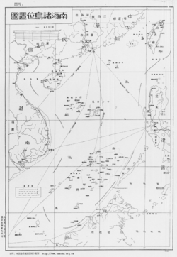
In 1947, the Republic of China drew up the map showing the U shaped claim on the entire South China Sea, showing the Spratly and Paracels in Chinese territory.[49] In 1947, the ROC government renamed 159 islands in the area and published the Map of the South China Sea Islands. The ROC was the first government to establish a physical presence in the Spratly Islands. It has occupied Taiping Island, the largest island in the Spratlys, constantly since 1956.[89]
The Republic of China (ROC), which ruled mainland China before 1949, has been confined to Taiwan since 1949. The People's Liberation Army and the Republic of China Armed Forces are both stationed in several islands, including the largest, Taiping Island – occupied by ROC.
After pulling out its garrison in 1950 when the Republic of China evacuated to Taiwan, when the Filipino Tomas Cloma uprooted an ROC flag on Itu Aba laid claim to the Spratlys and, the Republic of China (now Taiwan) again regarrisoned Itu Aba on 1956.[90]
Taiwan's garrison from 1946–1950 and 1956-now on Itu Aba represents an "effective occupation" of the Spratlys.[52][53] China established a coastal defence system against Japanese pirates or smugglers.[91]
In 1958, the People's Republic of China, having taken over mainland China and having left the Republic of China with control over Taiwan, Penghu, Kinmen, Matsu, and some outlying islands, issued a declaration of a 12 nautical mile limit territorial waters that encompassed the Spratly Islands. North Vietnam's prime minister, Phạm Văn Đồng, sent a formal note to PRC's Premier Zhou Enlai to recognise these claims; and stated that the Government of the Democratic Republic of Vietnam (North Vietnam) respects the decision on the 12 nautical mile limit territorial waters, although South Vietnam continued to claim sovereignty over the islands.
North Vietnam recognised China's claims on the Paracels and Spratlys during the Vietnam War as it was being supported by China. Only after winning the war and conquering South Vietnam did North Vietnam retract its recognition and admitted it recognised them as part of China to receive aid from China in fighting the Americans.[92]
The Philippines claimed the Spratlys in 1971 under President Marcos, after Taiwanese troops attacked and shot at a Philippine fishing boat on Itu Aba.[52]
Under President Lee Teng-hui, Taiwan stated that "legally, historically, geographically, or in reality", all of the South China Sea and Spratly islands were Taiwan's territory and under Taiwanese sovereignty, and denounced actions undertaken there by Malaysia and the Philippines, in a statement on 13 July 1999 released by the foreign ministry of Taiwan.[93] Taiwan and China's claims "mirror" each other; during international talks involving the Spratly islands, China and Taiwan have cooperated with each other since both have the same claims.[52][94]
Taiwan and China are largely strategically aligned on the Spratly islands issue, since they both claim exactly the same area, so Taiwan's control of Itu Aba (Taiping) island is viewed as an extension of China's claim.[46] Taiwan and China both claim the entire island chain, while all the other claimaints only claim portions of them. China has proposed co-operation with Taiwan against all the other countries claiming the islands. Taiwanese lawmakers have demanded that Taiwan fortify Itu Aba (Taiping) island with weapons to defend against the Vietnamese, and both China and Taiwanese NGOs have pressured Taiwan to expand Taiwan's military capabilities on the island, which played a role in Taiwan expanding the island's runway in 2012.[95] China has urged Taiwan to co-operate and offered Taiwan a share in oil and gas resources while shutting out all the other rival claimaints. Taiwanese lawmakers have complained about repeated Vietnamese aggression and trespassing on Taiwan's Itu Aba (Taiping), and Taiwan has started viewing Vietnam as an enemy over the Spratly Islands, not China.[96] Taiwan's state run oil company CPC Corp's board director Chiu Yi has called Vietnam as the "greatest threat" to Taiwan.[95] Taiwan's airstrip on Taiping has irritated Vietnam.[97] China views Taiwan's expansion of its military and airstrip on Taiping as benefiting China's position against the other rival claimaints from southeast Asian countries.[53] China's claims to the Spratlys benefit from legal weight because of Taiwan's presence on Itu Aba, while America on the other hand has regularly ignored Taiwan's claims in the South China Sea and does not include Taiwan in any talks on dispute resolution for the area.[98]
Malaysia has militarily occupied three islands that it considers to be within its continental shelf. Swallow Reef (Layang Layang / Terumbu Layang / Pulau Layang Layang) was under control on 1983 and has been turned into an island through a land reclamation which now also hosts a dive resort.[37] The Malaysian military also occupies Ardasier Reef (Terumbu Ubi), and Mariveles Reef (Terumbu Mantanani).[33]
Since 1992, Malaysia and Vietnam have agreed to jointly develop areas around these disputed islands.[99] Malaysia has made it known that its policy is to maintain peace and resolve disputes using diplomacy. It trusts that China is not an aggressive country and believes China only wants its presence to be known. Malaysia has said that it is always monitoring all of the actions made by countries involved in the dispute.[100]
Taiwan performed live fire military exercises on Taiping island in September 2012; reports said that Vietnam was explicitly named by the Taiwanese military as the "imaginary enemy" in the drill. Vietnam protested against the exercises as violation of its territory and "voiced anger", demanding that Taiwan stop the drill. Among the inspectors of the live fire drill were Taiwanese national legislators, adding to the tensions.[101]
In 2010, it was reported that the former Malaysian Prime Minister Mahathir Mohamad believed Malaysia could profit from China's economic growth through co-operation with China,[102] and said that China "was not a threat to anyone and was not worried about aggression from China", as well accusing the United States of provoking China and trying to turn China's neighbours against China.[103] Malaysia displayed no concern over China conducting a military exercise at James Shoal in March 2013.[104] Malaysia also suggested that it might work with China with Malaysian Defence Minister Hishamuddin Hussein saying that Malaysia had no problem with China patrolling the South China Sea, and telling ASEAN, America, and Japan that "Just because you have enemies, doesn't mean your enemies are my enemies".[105] However, until present Malaysia still maintained a balance relations with the countries involved in this dispute.[106] But since China has start enroaching its territorial waters,[107] Malaysia has become active in condemning China.[108][109]
The editorial of the Taiwanese news website "Want China Times" accused America for being behind the May 2014 flareup in the South China Sea, saying that Vietnam rammed a Chinese vessel on 2 May over an oil rig drilling platform and the Philippines detained 11 Chinese fishermens occurred because of Obama's visit to the region and that they were incited by America "behind the scenes". "Want China Times" claimed America ordered Vietnam on 7 May to complain about the drilling platform, and noted that a joint military exercise was happening at this time between the Philippines and America, and also noted that the American "New York Times" newspaper supported Vietnam.[110]
The Moro National Liberation Front (MNLF) of Nur Misuari declared its support for China against the Philippines in the South China Sea dispute, calling both China and the Moro people as victims of Philippine colonialism, and noting China's history of friendly relations with the Moros.[111] The MNLF also denounced America's assistance to the Philippines in their colonisation of the Moro people in addition to denouncing the Philippines claims to the islands disputed with China, and denouncing America for siding with the Philippines in the dispute, noting that in 1988 China "punished" Vietnam for attempting to set up a military presence on the disputed islands, and noting that the Moros and China maintained peaceul relations, while on the other hand the Moros had to resist other colonial powers, having to fight the Spanish, fight the Americans, and fight the Japanese, in addition to fighting the Philippines.[112]
The New York Times claimed the peace deal between the Philippines and Moro Islamic Liberation Front (MILF) "seeks to bring prosperity to the restive south and weaken the appeal of the extremist groups.", and linked the winding down of an American military counter-terrorism operation to increased American military co-operation with the Philippines against China.[113] The New York Times hailed Mr Aquino's "peace agreement" as an "accomplishment" as it reported on Aquino raising the "alarm" on China in the South China Sea.[114] The New York Times editorial board published an article siding with the Philippines against China in the South China Sea dispute and supporting the Philippines actions against China.[115][116] The New York Times editorial board endorsed aggressive American military action against China in the South China Sea.[117][118]
Champa historically had a large presence in the South China Sea. The Vietnamese broke Champa's power in an invasion of Champa in 1471, and then finally conquered the last remnants of the Cham people in an invasion in 1832. A Cham named Katip Suma who received Islamic education in Kelantan declared a Jihad against the Vietnamese, and fighting continued until the Vietnamese crushed the remnants of the resistance in 1835. The Cham organization Front de Libération du Champa was part of the United Front for the Liberation of Oppressed Races, which waged war against the Vietnamese for independence in the Vietnam War along with the Montagnard and Khmer Krom minorities. The last remaining FULRO insurgents surrendered to the United Nations in 1992. Vietnam has settled over a million ethnic Vietnamese on Montagnard lands in the Central Highlands. The Montagnards staged massive protests against the Vietnamese in 2001 and 2004, which led to the Vietnamese to forcefully crush the uprisings.
The Vietnamese government fears that using the evidence of Champa's historical connection to the disputed islands in South China Sea would expose the human rights violations and killings of ethnic minorities in Vietnam such as in the 2001 and 2004 uprisings, and lead to the issue of Cham autonomy being brought to attention, since the Vietnamese conquered the Hindu and Muslim Cham people in a war in 1832, and the Vietnamese continue to destroy evidence of Cham culture and artifacts left behind, plundering or building on top of Cham temples, building farms over them, banning Cham religious practices, and omitting references to the destroyed Cham capital of Song Luy in the 1832 invasion in history books and tourist guides. The situation of Cham compared to the ethnic Vietnamese is substandard, lacking water and electricity and living in houses made out of mud.[119]
See also
- Chinese reunification
- Great wall of sand
- Greater Philippines
- Sansha
- Senkaku Islands dispute
- Kuril Islands dispute
References
- ↑ rpazos@st. "Before and after satellite images: What has been built on disputed islands in the South China Sea". The Straits Times. Retrieved 2016-02-29.
- 1 2 China goes all out with major island building project in Spratlys – IHS Jane's 360. Janes.com (20 June 2014). Retrieved 12 May 2015.
- ↑ Page, Jeremy. (16 April 2015) China Building Airstrip in Spratly Islands, Satellite Images Show. The Wall Street Journal. Retrieved 12 May 2015.
- 1 2 Island building in the South China Sea. Stuff.co.nz. Retrieved 12 May 2015.
- ↑ http://www.abc.net.au/news/2015-09-22/south-china-sea-islands-before-and-after/6794076
- ↑ Bowring, Philip (6 May 1994). "China Is Getting Help in a Grab at the Sea". The New York Times. Retrieved 29 October 2013.
- ↑ "Chronological lists of ratifications of, accessions and successions to the Convention and the related Agreements as at 29 October 2013". Division for Ocean affairs and the Law of the sea. United Nations. Retrieved 19 May 2014.
- ↑ Note that the oil and gas discovered in the region so far has been in shallow / coastal-shelf waters, whereas (with notable exceptions), the majority of waters in the area are very deep, and unexplored. (One of the exceptions is the Reed Bank area.) Source: "South China Sea" (PDF). US Energy Information Administration (eia). 7 February 2013. p. 13. Retrieved 7 June 2014.
- ↑ "Contested areas of South China Sea likely have few conventional oil and gas resources – Today in Energy – U.S. Energy Information Administration (EIA)". www.eia.gov. Retrieved 23 May 2015.
- ↑ "All those oil and gas deposits everyone wants in the South China Sea may not even be there". Foreign Policy. Retrieved 23 May 2015.
- ↑ Veloso Abueva, Jose (1999). Admiral Tomas Cloma, father of maritime education and discoverer of freedomland / Kalayaan Islands. Center for Leadership, Citizenship and Democracy, National College of Public Administration and Governance, University of the Philippines (Diliman, Quezon City).
- ↑ Guo, Rongxing. Territorial Disputes and Resource Management. p. 229.
- ↑ TED (Trade and Environment Database), Mandala Project (December 1997). "Spratly Islands Dispute". ICE Case Studies. American University.
- ↑ Lai To, Lei (1999). Chian and the South China Sea dialogues. Westport: Praeger Publishers. p. 63. ISBN 978-0-275-96635-5.
- ↑ Kate, Daniel (27 May 2011). "South China Sea Oil Rush Risks Clashes as U.S. Emboldens Vietnam on Claim". Bloomberg News. Retrieved 29 October 2013.
- ↑ World review of fisheries and aquaculture (PDF). Rome: FAO- Food and Agriculture Organisation. 2012. pp. 55–59.
- 1 2 Lily B. Libo-on (13 June 2003). "When All Else Has Failed, Diplomacy Sets In". Borneo Bulletin. Archived from the original on 7 January 2005. (Archived from the original on 2005-01-07).
Additionally, pages 48 and 51 of "The Brunei-Malaysia Dispute over Territorial and Maritime Claims in International Law" by R. Haller-Trost, Clive Schofield, and Martin Pratt, published by the International Boundaries Research Unit, University of Durham, UK, points out that this is a "territorial dispute" between Brunei and other claimants over the ownership of one above-water feature – Louisa Reef. - ↑ Commission on the Limits of the Continental Shelf (CLCS), United Nations
- 1 2 "China asserts sea border claims". BBC. 13 May 2009. Retrieved 11 June 2009.
- ↑ Refer to the CLCS website for more information on Brunei's preliminary submission.
- ↑ "Foreign Ministry Spokesperson Ma Zhaoxu's remarks on Vietnam's Submission on Outer Limits of the Continental Shelf in South China Sea". Ministry of Foreign Affairs, People's Republic of China. 10 May 2009. Archived from the original on 28 May 2009. Retrieved 11 June 2009.
- ↑ "Philippines warns of arms race in South China Sea". Inquirer Global Nation. Agence France-Presse. 24 May 2011.
- ↑ "PH to take China dispute to UN tribunal". Rappler. 22 January 2013. Retrieved 25 March 2014.
- 1 2 "The Republic of the Philippines v. The People's Republic of China". Permanent Court of Arbitration.
- ↑ Caprio argues:
Coastal states are entitled to a 200-nautical-mile (370 km; 230 mi) Exclusive Economic Zone. This is only subject to delimitation in case of overlapping EEZs with other coastal states. Under UNCLOS, EEZs are measured from a baseline drawn from the coast of continental land, or from an island capable of human habitation. It means that rocks submerged during high tide cannot be used as the basis to draw an EEZ. This basic requirement is taken from the universal international law principle that the "land dominates the sea". This implies that areas in the seas and oceans can be claimed and measured only from land; a continental land or island "capable of human habitation of its own".
Under UNCLOS, full sovereignty over its 12 nautical miles (22 km; 14 mi) territorial sea is given to coastal states. Beyond the territorial sea, the coastal state has only specific "sovereign rights" up to 200 nautical miles (370 km; 230 mi) from its baselines. All other states do not enjoy the application or the benefit of these "sovereign rights". The term "sovereign rights" refers to specific rights that do not amount to full "sovereignty".- A coastal state's "sovereign rights" to its EEZ beyond the territorial sea refer principally to the exclusive right to exploit the living and non-living resources in the area, without other sovereign rights like the right to deny freedom of navigation and over-flight, which a coastal state can deny in its territorial sea."
- ↑ http://www.rappler.com/nation/137202-philippines-china-ruling-case-west-philippine-sea
- ↑ http://cil.nus.edu.sg/rp/pdf/1992%20ASEAN%20Declaration%20on%20the%20South%20China%20Sea-pdf.pdf
- 1 2 "Declaration on the Conduct of Parties in the South China Sea". Association of Southeast Asian Nations. 4 November 2002.
- ↑ "China open to discussion on South China Sea code". China Daily. 13 July 2012.
- ↑ "S.Res.524 – A resolution reaffirming the strong support of the United States for the 2002 declaration of conduct of parties in the South China Sea among the member states of ASEAN and the People's Republic of China, and for other purposes.". United States Congress. 2 August 2012. Retrieved 3 February 2013.
In a statement released on 3 August 2012, United States Department of State deputy spokesman Patrick Ventrell said that the US has a "national interest in the maintenance of peace and stability, respect for international law, freedom of navigation, and unimpeded lawful commerce in the South China Sea." He added that the US does not take a position on competing territorial claims and that it urges all involved parties to clarify and pursue their territorial and maritime claims in accordance with international law. He further said the US is urging all parties to take steps to lower tensions in keeping with the 1992 ASEAN Declaration on the South China Sea and the 2002 ASEAN-China Declaration on the Conduct of Parties in the South China Sea.
Patrick Ventrell (3 August 2012). "South China Sea". United States Department of State. Retrieved 3 February 2013.
The United States has supported the Philippines and Vietnam by expanding military ties.
"US voices concern over South China Sea rows". Al Jazeera. 4 August 2012. Retrieved 3 February 2013. - ↑ "Speech delivered to the Australian Strategic Policy Institute" (PDF). Commander, US Pacific Fleet. U.S. Navy. 31 March 2015. Retrieved 2015-05-29.
- ↑ "China completes runway on Fiery Cross Reef". janes.com. Retrieved 28 September 2015.
- 1 2 3 4 Territorial claims in the Spratly and Paracel Islands, globalsecurity.org
- ↑ Oceans & Law of the Sea, United Nations
- ↑ "Overview". United Nations Convention on the Law of the Sea of 10 December 1982. United Nations. 22 August 2013.
- ↑ Spratly Island Dispute (SPRATLY Case), 30 April 1996, Trade Environment Database (TED), American University. (Archived from the original on 22 July 2012)
- 1 2 3 Ooi, Keat Gin (2004). Southeast Asia: A Historical Encyclopedia, from Angkor Wat to East Timor. ABC-CLIO. pp. 1241–. ISBN 978-1-57607-770-2.
- ↑ Chia Lin Sien (2003). Southeast Asia Transformed: A Geography of Change. Institute of Southeast Asian Studies. pp. 78–. ISBN 978-981-230-119-2.
- ↑ Furtado, Xavier (December 1999). "International Law and the Dispute over the Spratly Islands: Whither UNCLOS?". Contemporary Southeast Asia. 21: 386–404.
- ↑ Beckman, Robert (2013). "The UN Convention on the Law of the Sea and the Maritime Disputes in the South China Sea". The American Journal of International Law. American Society of International Law. 107 (1): 142–163. JSTOR 10.5305/amerjintelaw.107.1.0142.
- ↑ 《元史》地理志;《元代疆域图叙》 [History of Yuan Geographic Records; Yuan dynasty Annotated Territory Map]
- ↑ 《海南卫指挥佥事柴公墓志铬》 [Hainan Commandery Comprehensive Public Memorial Records]
- 1 2 《清直省分图》天下总舆图 [Qing dynasty Provincial maps: Tianxia Overview Map]
- ↑ 《大清一统天下全图》 [Qing dynasty Overview Tianxia Map]
- ↑ Undersea Treasure Chest Stirs up Tensions, BBC, 29 April 1999.
- 1 2 3 4 5 Wortzel, Larry M.; Higham, Robin D. S. (1999). Dictionary of Contemporary Chinese Military History (illustrated ed.). ABC-CLIO. p. 180. ISBN 0313293376.
- 1 2 3 4 5 6 7 8 Kivimäki, Timo, ed. (2002). War Or Peace in the South China Sea?. Contributor: Nordic Institute of Asian Studies (illustrated ed.). NIAS Press. pp. 9–11. ISBN 8791114012. ISSN 0904-597X. Retrieved 10 March 2014.
- 1 2 3 Bateman, Sam; Emmers, Ralf, eds. (2008). Security and International Politics in the South China Sea: Towards a co-operative management regime (illustrated ed.). Taylor & Francis. p. 43. ISBN 0203885244. Retrieved 10 March 2014.
- 1 2 3 4 5 6 7 8 Severino, Rodolfo (2011). Where in the World is the Philippines?: Debating Its National Territory (illustrated ed.). Institute of Southeast Asian Studies. pp. 74, 76. ISBN 9814311715.
- 1 2 Morley, James W.; Nishihara, Masashi (1997). Vietnam Joins the World. M.E. Sharpe. p. 124. ISBN 978-0-7656-3306-4.
- 1 2 Das, Darshana & Lotha, Gloria. "Spratly Islands". Encyclopædia Britannica.
- 1 2 3 4 Pak, Hŭi-gwŏn (2000). The Law of the Sea and Northeast Asia: A Challenge for Cooperation. Volume 35 of Publications on Ocean Development (illustrated ed.). Martinus Nijhoff Publishers. pp. 91–92. ISBN 9041114076.
- 1 2 3 Lin, Cheng-yi (22 February 2008). "Buffer benefits in Spratly initiative". Asia Times Online. Retrieved 14 May 2014.
- ↑ Taoka, Shunji (21 September 2015). Translated by Rumi Sakamoto. "'China Threat Theory' Drives Japanese War Legislation". The Asia-Pacific Journal. Japan Focus. 13 (38 (number 5)). Retrieved 26 September 2015.
- ↑ Womack 2006, p. 218 Womack, Brantly. China and Vietnam. Cambridge University Press, 2006
- ↑ "PRESIDENTIAL DECREE NO. 1596 – DECLARING CERTAIN AREA PART OF THE PHILIPPINE TERRITORY AND PROVIDING FOR THEIR GOVERNMENT AND ADMINISTRATION". Chan Robles Law Library. 11 June 1978.
- ↑ Furtado, Xavier (December 1999). "International Law and the Dispute over the Spratly Islands: Whither UNCLOS?". Contemporary Southeast Asia. 21: 386–404.
- ↑ "UNCLOS. Declarations upon ratification: Viet Nam".
- ↑ The Sino-Vietnamese difference on the Hoang Sa and Truong Sa archipelagos, Luu Van Loi, 1996, The Gioi publisher Archived 27 March 2009 at the Wayback Machine.
- ↑ Ling Wai Dai Da (Information on Things Beyond the Passes) by Zhou Choufei
- ↑ Zhu Fan Zhi (Notes on Foreign Countries) by Zhao Juguo
- ↑ Dzurek, Daniel J.; Schofield, Clive H. (1996). The Spratly Islands dispute: who's on first?. IBRU. p. 8. ISBN 978-1-897643-23-5.
- 1 2 3 4 "The Vietnamese state's long standing and uninterrupted sovereignty over the Hoang Sa and Truong Sa archipelagoes". Authority of Foreign Information Service (Vietnam). Retrieved 28 October 2012.
- ↑ "Cairo Communiquè, December 1, 1943". Japan National Diet Library. 1 December 1943.
- ↑ San Francisco Peace Treaty. Taiwandocuments.org. Retrieved 12 May 2015.
- ↑ "Agreement on the Cessation of Hostilities in Vietnam". Office of the Historian, Bureau of Public Affairs, United States Department of State.
- 1 2 3 4 Thao Vi (2 June 2014). "Late Vietnam PM's letter gives no legal basis to China's island claim". Thanh Nien News.
- ↑ "The 2009 Vietnam Population and Housing census: Completed results". General Statistics Office of Vietnam. Retrieved December 20, 2012.
- ↑ China gets tough as Vietnam claims disputed islands, Sydney Morning Herald, 23 June 2012 (archived from the original on 22 June 2012).
- ↑ Perlez, Jane (21 June 2012). "China Criticizes Vietnam in Dispute Over Islands – Pittsburgh Post-Gazette". Pittsburgh Post-Gazette.
- ↑ Ian Glover (2004). Southeast Asia: From Prehistory to History. Psychology Press. p. 209. ISBN 978-0-415-29777-6.
Bill Hayton (11 September 2014). The South China Sea: The Struggle for Power in Asia. Yale University Press. pp. 14–16. ISBN 978-0-300-18954-4.
Robert D. Kaplan (25 March 2014). Asia's Cauldron: The South China Sea and the End of a Stable Pacific. Random House Publishing Group. pp. 12–16. ISBN 978-0-8129-9433-9.
Anthony Reid (1 August 2000). Charting the Shape of Early Modern Southeast Asia. Silkworm Books. pp. 34–38. ISBN 978-1-63041-481-8. - ↑ Bray, Adam (16 June 2014). "The Cham: Descendants of Ancient Rulers of South China Sea Watch Maritime Dispute From Sidelines". National Geographic News. National Geographic. Archived from the original on 2014. Retrieved 3 September 2014.
- ↑ Sovereignty Over the Paracel and Spratly Islands. Kluwer Law International. 2000. p. 72. ISBN 978-90-411-1381-8.
- ↑ "International Claims in Spratly and Oil Claims". paracelspratly.com. Archived from the original on 9 April 2008.
- ↑ Chang, Teh-Kuang (1991). "China 's Claim of Sovereignty over Spratly and Paracel Islands: A Historical and Legal Perspective".
- ↑ Keck, Zachary (13 March 2014). "Second Thomas Shoal Tensions Intensify". The Diplomat. Retrieved 17 March 2014.
- ↑ Himmelman, Jeff; Gilbertson, Ashley (24 October 2013). "A game of shark and minnow". The New York Times. Retrieved 17 March 2014.
- ↑ Philippine Baselines Law of 2009 signed, GMA News, 11 March 2009.
- ↑ Joint submission by Malaysia and the Socialist Republic of Viet Nam. United Nations Commission on the Limits of the Continental Shelf. 28 May 2009. Retrieved 18 September 2009.
- ↑ Submission by the Socialist Republic of Viet Nam. United Nations Commission on the Limits of the Continental Shelf. 28 May 2009. Retrieved 18 September 2009.
- ↑ Ian Mansfield (18 May 2011) China Mobile expands coverage to the Spratly Islands, Cellular News
- ↑ "Chinese naval maneuvers seen as warning to Vietnam". Chinh's News. 18 June 2011.
- ↑ Chinese frigate runs aground in disputed part of South China Sea | World news. The Guardian. Retrieved 12 May 2015.
- ↑ Mogato, Manuel; Blanchard, Ben (7 May 2014). "Tensions surge in S. China Sea as Philippines seizes Chinese boat". Reuters. Retrieved 7 May 2014.
- ↑ "Exclusive: China warns U.S. surveillance plane - CNNPolitics.com". CNN. Retrieved 23 May 2015.
- ↑ "Why China's island-building is raising eyebrows - CNN.com". CNN. Retrieved 23 May 2015.
- ↑ "US May Use Military to Confront China in Spratly Island Dispute". Manila Livewire. Manila Livewire Digital Media Group. Retrieved 23 May 2015.
- ↑ "Exclusive: China sends surface-to-air missiles to contested island in provocative move". Fox News. Retrieved 16 Feb 2016.
- ↑ Wiencek, David G. (2002). Cooperative monitoring in the South China Sea: satellite imagery, confidence-building measures, and the Spratly Islands disputes. Greenwood Publishing Group. p. 19. ISBN 978-0-275-97182-3.
- ↑ Morley & Nishihara 1997, pp. 125–126
- ↑ Pak 2000, p. 81
- ↑ Morley & Nishihara 1997, pp. 126–127
- ↑ STRATFOR (14 July 1999). "Taiwan sticks to its guns, to U.S. chagrin". STRATFOR's Global Intelligence Update. Asia Times. Retrieved 10 March 2014.
- ↑ Sisci, Francesco (29 June 2010). "US toe-dipping muddies South China Sea". Asia Times Online. Retrieved 14 May 2014.
- 1 2 Kastner, Jens (10 August 2012). "Taiwan pours cement on maritime dispute". Asia Times Online. Retrieved 10 March 2014.
- ↑ Kastner, Jens (13 June 2012). "Taiwan circling South China Sea bait". Asia Times Online. Retrieved 14 May 2014.
- ↑ Lee, Peter (29 July 2010). "US goes fishing for trouble". Asia Times Online. p. 2. Retrieved 14 May 2014.
- ↑ Womack, Brantly (14 February 2013). "Rethinking the US-China-Taiwan triangle". Asia Times Online. Retrieved 14 May 2014.
- ↑ Sik, Swan (1994). Asian Yearbook of International Law: 1992. Martinus Nijhoff Publishers. pp. 344–. ISBN 0-7923-2239-8.
- ↑ "Resolve South China Sea Disputes Diplomatically – Ahmad Zahid". Ministry of Foreign Affairs, Malaysia. 8 August 2011. Retrieved 17 May 2014.
- ↑ I really don't think this many references are required, particularly given that one sub-group appear to be duplicates, and another sub-group appear to refer to a different time period ...
- "Photo: Taiwan military exercises with Vietnam as an imaginary enemy generals admit Taiping Island". newshome.us. 5 September 2012. Retrieved 14 May 2014.
- "Taiwan holds live-fire drill in Spratlys: official". Taipei Mission in the Republic of Latvia. 23 April 2013. Retrieved 14 May 2014.
- "Taiwan to stage live-fire drill on disputed island". Space Daily. Agence France-Presse. 1 March 2013. Retrieved 14 May 2014.
- "Taiwan to stage live-fire drill on disputed island". Business Line. Press Trust of India. 1 March 2013. Retrieved 14 May 2014.
- Yeh, Joseph (23 April 2013). "Drills held on Taiwan-controlled Taiping island in South China Sea". China Post. Retrieved 14 May 2014.
- "Vietnam Demands Taiwan Cancel Spratly Island Live Fire Drill". Bloomberg News. 23 August 2012. Retrieved 14 May 2014.
- "Vietnam protests Taiwan's fire drill exercise plan on island". thanhniennews. 27 August 2012. Retrieved 14 May 2014.
- "Vietnam protests Taiwan's fire drill exercise plan on island". Thanh Nien News. 23 August 2012. Retrieved 14 May 2014.
- "Taiwan to hold live-fire drill in Spratlys". InterAksyon. Agence France-Presse. 1 March 2013. Retrieved 14 May 2014.
- "Taiwan unmoved by Vietnam's protest against Taiping drill". Want China Times : "Knowing China through Taiwan". 5 September 2012. Retrieved 14 May 2014.
- "Vietnam angry at Taiwan as it stages live-fire drill in the Spratlys". Philippines News. Agence France-Presse. 12 August 2012. Archived from the original on 25 March 2014.
- "Taiwan to conduct live-fire Taiping Island drill in Sept.". China Post. 21 August 2012. Retrieved 14 May 2014.
- "Taiwan plans live-fire drill on Taiping in South China Sea". Taipei Times. 21 August 2012. Retrieved 14 May 2014.
- Carpenter, Ted Galen (28 February 2013). "Taiwan Challenges Its Neighbors". The National Interest. Retrieved 10 March 2014.
- Carpenter, Ted Galen (28 February 2013). "Taiwan Challenges Its Neighbors". The National Interest. Cato Institute. Retrieved 10 March 2014.
- Carpenter, Ted Galen (4 March 2013). "Taiwan Challenges Its Neighbors". Real Clear Politics. Cato Institute. Retrieved 10 March 2014.
- Carpenter, Ted Galen (28 February 2013). "Taiwan Challenges Its Neighbors". LibertyVoter.org. Retrieved 10 March 2014.
- thanhniennews (27 August 2012). "Vietnam protests Taiwan's fire drill exercise plan on island". Vietnam Breaking News.
- (AFP) (12 August 2012). "Vietnam's angry at Taiwan as it stages live-fire drill in the Spratlys". Philippines News. Archived from the original on 25 March 2014.
- "Vietnam protests Taiwan's fire drill exercise plan on island". Thanh Nien News. 23 August 2012. Retrieved 14 May 2014.
- ↑ "Mahathir: China no threat to Malaysia". The Star. 27 April 2010. Archived from the original on 30 April 2010. Retrieved 14 May 2014.
- ↑ Kazuto Tsukamoto (9 November 2011). "Malaysia's Mahathir says China is no threat". The Asahi Shimbun. Retrieved 14 May 2014.
- ↑ Shahriman Lockman (24 April 2013). "Why Malaysia isn't afraid of China (for now)". The Strategist: The Australian Strategic Policy Institute Blog. Retrieved 14 May 2014.
- ↑
- Haslinda Amin (29 August 2013). Malaysia Breaks Ranks on South China Sea (video). First Up. Bloomberg. Retrieved 14 May 2014.
- "Malaysia splits with ASEAN on China Sea threat". Bloomberg. Business Mirror. 29 August 2013. Retrieved 14 May 2014.
- ↑ Camille Diola (25 June 2014). "Why Malaysia, unlike Philippines, keeps quiet on sea row". The Philippine Star. Retrieved 25 June 2014.
- ↑ "Presence of China Coast Guard ship at Luconia Shoals spooks local fishermen". The Borneo Post. 27 September 2015. Retrieved 28 September 2015.
- ↑ "Malaysia lodges diplomatic protest against intrusion at Beting Patinggi Ali". Bernama. The Rakyat Post. 15 August 2015. Retrieved 16 August 2015.
- ↑ Ben Blanchard; Richard Pullin (18 October 2015). "Malaysia slams China's 'provocation' in South China Sea". Reuters. Channel News Asia. Retrieved 20 October 2015.
- ↑ Editorial, 13 May 2014, Want China Times
- ↑ RRayhanR (8 October 2012). "HISTORICAL AND 'HUMAN WRONG' OF PHILIPPINE COLONIALISM: HOW NOT TO RESPECT HISTORIC-HUMAN RIGHTS OF BANGSAMORO AND CHINA?". mnlfnet.com. Moro National Liberation Front (Misuari faction). Retrieved 16 May 2014.
- ↑ "IMPACT OF POSSIBLE CHINA-PHILIPPINES WAR WITHIN FILIPINO-MORO WAR IN MINDANAO". mnlfnet.com. Moro National Liberation Front (Misuari faction). 11 August 2012. Retrieved 16 May 2014.
- ↑ WHALEY, FLOYD; SCHMITT, ERIC (26 June 2014). "U.S. Phasing Out Its Counterterrorism Unit in Philippines". The New York Times.
- ↑ BRADSHER, KEITH (5 February 2014). "Philippine Leader Sounds Alarm on China". The New York Times.
- ↑ THE EDITORIAL BOARD (17 July 2015). "The South China Sea, in Court". The New York Times.
- ↑ THE EDITORIAL BOARD (2 April 2014). "Risky Games in the South China Sea". The New York Times.
- ↑ THE EDITORIAL BOARD (29 May 2015). "Pushback in the South China Sea". The New York Times.
- ↑ THE EDITORIAL BOARD (12 July 2014). "Still at Odds With China". The New York Times.
- ↑ Bray, Adam (16 June 2014). "The Cham: Descendants of Ancient Rulers of South China Sea Watch Maritime Dispute From Sidelines". National Geographic News. National Geographic. Archived from the original on 2014. Retrieved 3 September 2014.
Further reading
- Bautista, Lowell B. (December 2011). "PHILIPPINE TERRITORIAL BOUNDARIES: INTERNAL TENSIONS, COLONIAL BAGGAGE, AMBIVALENT CONFORMITY" (PDF). JATI – Journal of Southeast Asian Studies. University of Malaya. 16: 35–53.
- Bautista, Lowell B. (February 2012). "The Implications of Recent Decisions on the Territorial and Maritime Boundary Disputes in East and Southeast Asia". maritime energy resources in asia : Legal Regimes and Cooperation : NBR Special Report No. 37. Academia.edu.
- Bautista, Lowell B. (1 January 2010). "The Legal Status of the Philippine Treaty Limits in International Law". Academia.edu. doi:10.1007/s12180-009-0003-5.
- Bautista, Lowell B. (Fall 2009). "The Historical Background, Geographical Extent and Legal Bases of the Philippine Territorial Water Claim". The Journal of Comparative Asian Development. 8 (2).
- François-Xavier Bonnet, Geopolitics of Scarborough Shoal, Irasec’s Discussion Papers, No. 14, November 2012.
- Dzurek, Daniel J.; Schofield, Clive H. (1996). The Spratly Islands dispute: who's on first?. IBRU. ISBN 978-1-897643-23-5.
- Emmers, Ralf (June 2007), "The De-escalation of the Spratly Dispute in Sino-Southeast Asian Relations" (PDF), S. Rajaratnam School of International Studies Working Paper (129)
- Forbes, Andrew, and Henley, David: Vietnam Past and Present: The North (Sino-Viet relations in Paracels and Spratlys). Chiang Mai. Cognoscenti Books, 2012. ASIN: B006DCCM9Q.
- Menon, Rajan, "Worry about Asia, Not Europe", The National Interest, Sept–Oct 2012 Issue, 11 September 2012
- Bezlova, Antoaneta (29 January 2008). "China moves to expand its reach". Asia Times Online. Retrieved 10 March 2014.
- "Timing of flareups in South China Sea is no coincidence". Want China Times. 13 May 2014. Retrieved 14 May 2014.
External links
- Spratlys website (pro-China)
- Paracels and Spratlys website (pro-Vietnam)
- Mariner's page of the Spratly Islands
- Taiwanese List with ~170 entries
- "The Dotted Line on the Chinese Map of the South China Sea: A Note" (PDF). (150 KB) (archived from the original on 2013-06-16)
- List of atolls with areas
- A tabular summary about the Spratly and Paracel Islands
- Third Party Summary of the Dispute
- Ji Guoxing (October 1995). "Maritime Jurisdiction in the Three China Seas: Options For Equitable Settlement" (PDF). Institute on Global Conflict and Cooperation.
- A collection of documents on Spratly and Paracel Islands by Nguyen Thai Hoc Foundation
- Inventory of Conflict and Environment (ICE), Spratly Islands Dispute
- Red Sky and Yellow Stars over Asia, an analysis by The CenSEI Report
- "Analysis Brief : Spratly Islands". US Energy Information Administration.
| ||||||||||
| ||||||||||
| ||||||||||||||||||||||||||||||||||||||||||||||||||||||||||||||||||||||||||||||||||||||||