Rajang River
| Rajang | |
| River | |
 The Rajang drainage basin | |
| Country | Malaysia |
|---|---|
| Source | Iran Mountains |
| Mouth | |
| - location | South China Sea, Malaysia |
| - elevation | 0 m (0 ft) |
| Length | 563 km (350 mi) |
The Rajang River (Malay: Sungai Rajang or Batang Rajang) is a river in Sarawak, Malaysia. The river is located in northwest of Borneo and it originates in the Iran Mountains. The river flows approximately 563 km into Kapit, and then to the South China Sea, making it the longest river in Malaysia.[1]
Some of the important tributaries are the Balui River, Katibas River, Ngemah River, Iran River, Pila River, Balleh River, Bangkit River and the Kanowit River.[1]
Malaysia's largest and tallest (160m) hydro electric project, Bakun Hydro Electric Dam Project, is located on narrow Bakun Fall of Balui River
Environmental history

During the Pleistocene epoch or Mesolithic period about 10,000 years ago, there was a 5 degrees Celsius drop in the global temperature. At mountaintops, rain became snow which accumulated as huge icy sheets (such as on Mount Kinabalu in Borneo), thus making a break in the global hydrological cycle. Due to lack of water discharge into the sea, there was a 120-meter drop of sea levels from the present time. The South China Sea dried up, exposing the Sunda Shelf and previous deep trenches became huge ancient rivers called the North Sunda River.
The Asian mainland, Malay Peninsula, Sumatra and Java were connected to Borneo via the landbridge of the exposed Sunda Shelf. The North Sunda River provided vital connection to the north, Baram and Rajang rivers in Sarawak to the east and Pahang River and Rompin River to the west of the massive land mass.
Evidence
Freshwater catfish from the Mekong River in Vietnam and Chao Phraya River in Thailand migrated and mated with those in the Baram and Rajang rivers in Sarawak, exchanging genetic material about 10,000 years ago, showing these river systems were connected. After the Holocene global temperatures increased, the landbridges and the Sunda River were inudated and the catfish populations were isolated. However, their genetic motives are still in the DNA as an evidence of the previous connections of Rajang River to other rivers in Indochina and Borneo.
Mouth
Bruit Island is situated inside the Rajang Delta, with a light house at the Sirik Point.[1]
Wildlife
Mammals
A total of 30 species of mammals are recorded along the Rajang basin in 2004. The mouth of the river is the only place where the dolphins can be sighted. Totally protected mammals include gibbon, langurs, black giant squirrel, slow loris, and tarsier. Civets, otters, bats, treeshrew, and primates are also included under Sarawak Wildlife Protection Ordinance 1998. Wild pigs and deers are the most frequently hunted animals by the locals while primates can be hunted incidentally.[2]
Birds
122 species of birds were sighted along the Rajang basin in 2004. 21 species were recorded along the mouth of the river while 96 species were recorded in Hose Mountains and 88 species at Lanjak Entimau which are located in the interior of Sarawak. The only endemic species of birds located at Rajang basin is Dusky munia which is found abundantly in paddy fields. Other species of birds which are commonly found along the Rajang basin are: Pacific swallow, Little spiderhunter, and Asian glossy starling. 20 species of birds (mainly eagles, egret, kingfishers, woodpeckers) are protected while 7 species of birds (mainly Hornbill and Pheasant) are totally protected under the Sarawak Wildlife Protection Ordinance 1998.[2]
Fish
A total of 164 fish species has been recorded at the Rajang basin in 2005.[3] Empurau (Tor tambroides) and Semah (Tor douronensis) fish are considered popular fishes among the locals.[4] Empurau fish is still found breeding near the upper tributaries of Rajang such as Balleh River and near the Bakun Dam.[5]
Settlements

The biggest town by the river is Sibu, some 60 kilometers upriver from the mouth of the Rajang. The next major settlement upriver is Kanowit built on the mouth of Kanowit River at the bank of Rajang River, approximately 174 kilometers from the coast of South China Sea and about an hour boat ride from Sibu, followed by Kapit as the last major town on the river. Other towns which located at its banks are Sarikei,[1] Bintangor,[1] Song and Belaga.
Transportation
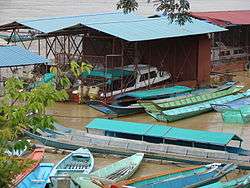
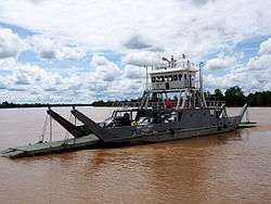
The town of Sibu can be assessed by oceangoing vessels for 80 miles (130 km) while an additional 100 miles (160 km) of the river can be assessed by shallow-draft craft. The remaining parts of the river which leads into the Sarawak interior can only be assessed by small canoes.[1] Speedboats and longboats are the major form of transport between Kapit and Belaga. Transportation above Belaga to Balui River requires longboats.[3] Rajang River also serves to transport logs down the river.[3]
Trade

Rajang Port Authority (RPA) is the main regulatory body to coordinate the trade activities of all the 5 river ports along the Rajang river. RPA serves to provide maintenance, adequate and efficient port services for all users of the ports. It is located at the Sibu port operation centre[6] (2°17′23.8″N 111°49′23.6″E / 2.289944°N 111.823222°E).
The 5 river ports along the Rajang river (arranged by their distances from the river mouth) are:[6]
- Tanjung Manis (30 km, maximum Gross register tonnage (GRT): 32,000 tonnes, mainly for handling logs and timber products)
- Sarikei (49 km, maximum GRT: 3,000 tonnes, mainly for handling agricultural products and consumer goods around Sarikei area)
- Bintangor (66 km, maximum GRT: 2,500 tonnes)
- Sibu (113 km, maximum GRT: 10,000 tonnes, mainly for handling timber and agricultural products)
- Sungai Merah (Near Sibu, 116 km, maximum GRT: 2,500 tonnes, mainly for handling fuel oil products)
Sibu and Sungai Merah can be assessed via a shorter route through Paloh river where the distances from the mouth of the river can be shortened to 82 km and 92 km respectively.[6]
In the year 2012, RPA recorded a total revenue of RM 30.1 million[7] although its total cargo throughput went down from 5.0 million to 3.2 million tonnes from the previous year.[8]
Tourism


Pandaw River Cruise was started on 1 July 2009 in order to boost tourism activities along the Rajang River. It was a nine-day cruising starting from Express Wharf Terminal of Sibu to Pelagus Rapids Resort in the rural interior of Sarawak. The tourists can go hiking and visiting long houses and towns during the ride.[9] However, this programme has been terminated in March 2012 because of logistical and operational difficulties.[10][11] During 2017 Visit Sibu Year, longhouse visits along the Rajang River was promoted as an ecotourism product. Crocodiles which are living by the river banks became the mascot for the event.[12]
Logjam disaster
On 6 October 2010, heavy rain in Putai and Nungun in upper Baleh is reported to have caused a massive landslide that brought logs and debris down into the Baleh river, tributaries above Kapit, and then into the Rajang river. It was estimated that the volume of the logs and debris had exceeded 300, 000 m3. This logjam had also affected the Igan river. The log debris, stretching 50 km long, had reached Sibu on 8 October. The logjam had caused transportation difficulties for the people living alongside the river and dead fish were also seen on the river.[13]
Sarawak environment and public health minister, Datuk Seri Wong Soon Koh claimed that the logjam disaster had never happened before in such a large scale. However, land development minister, Datuk Seri James Masing claimed that similar incidents did happen before and he blamed the disaster on indiscriminate logging by irresponsible logging companies.[13] Meanwhile, Sarawak state forest director, Len Talif blamed the logjam solely on the increased concentration of rain during that period.[14][15] The state's chief minister, Abdul Taib Mahmud had advised the people of Sarawak not to accuse anyone for the causes of this logjam and he assured that the state government will probe into this matter.[16]
As on 2 November 2012, Global Witness in a report entitled "In the Future There Will Be No Forests Left", revealed that the logging operation of Interglobal Empire, a subsidiary of WTK group of companies, in the logging concession T/3476 was responsible for the landslide into Melatai River which subsequently blocked the Rajang River. Taib Mahmud daughters, namely Jamilah and Hanifah Taib are substantial shareholders of WTK and Taib's brother Tufail is the director of one of the major WTK subsidiaries.[17]
Water quality
Logging operations are rampant on the upstream of Rajang river. A major study conducted along the Rajang river from May to December 2004 found out that the main channel of the Rajang river was turbid except for smaller tributaries. The water transparency was about 4 cm to 5 cm at that time. Based on Taxonomic richness index, the stretch of upstream river between Kanowit and Belaga river is recovering from logging 15 to 20 years ago with the exception of Penaan river because the local community uses toxic chemicals to capture fish. The stretch of river downstream from Lebaan to Selalang river is considered unclean.[18]
See also
References
- 1 2 3 4 5 6 Rajang River Encyclopædia Britannica. URL assessed on 2 September 2012
- 1 2 Tuen, A.A (2004). "A Faunal Study of Rajang River Basin" (PDF). Institute of Biodiversity and Environmental Conservation (Universiti Malaysia Sarawak). Retrieved 5 June 2014.
- 1 2 3 Parenti, L.R; Lim, K.P (2005). "Fishes of the Rajang Basin, Sarawak, Malaysia" (PDF). The Raffles Bulletin of Zoology. 13: 175–208. Retrieved 2 September 2012.
- ↑ Stephen, E.S. "Breeding The 'King' Of Sarawak Rivers". Bernama. Retrieved 2 September 2012.
- ↑ Chua, Endy (4 January 2011). "The lure of the empurau". The Star (Malaysia). Retrieved 2 September 2012.
- 1 2 3 "About Us - Operation centres". Official website of Rajang Port Authority. Retrieved 15 June 2014.
- ↑ "More revenue for Rajang Port Authority despite lower throughput". The Borneo Post. 14 February 2014. Retrieved 23 June 2014.
- ↑ "Port Performance Statistic". Official website of Rajang Port Authority. Retrieved 23 June 2014.
- ↑ "900 sign up for Rajang luxury cruise (subscription required)". New Straits Times. 2 March 2009. Retrieved 2 September 2012.
- ↑ Hii, Philip (21 March 2012). "After its final Rajang tour, RV Orient Pandaw will be deported to Myanmar". The Star (Malaysia). Retrieved 2 September 2012.
- ↑ Tan, Raymond (27 December 2011). "Cruising into the sunset". The Borneo Post. Retrieved 2 September 2012.
- ↑ Banji, Conny (25 February 2016). "Rajang River a tourist attraction, says Andrew Wong". The Borneo Post. Archived from the original on 4 March 2016. Retrieved 19 March 2016.
- 1 2 Hii, Philip (9 October 2010). "50km logjam on the Rajang river". The Star (Malaysia). Star Publications. Retrieved 17 October 2010.
- ↑ Tawie, Joseph (21 October 2010). "Logjam disaster: Blame it on the rain, not the loggers". Free Malaysia Today. Free Malaysia Today. Retrieved 8 November 2012.
- ↑ Petley, Dave (21 October 2010). "The curious story of the Rajang log jam in Sarawak, Malaysia". Dave Petley. American Geophysics Union blogosphere. Retrieved 8 November 2012.
- ↑ Sibon, Peter (11 October 2010). "CM: We will probe cause of logjam". The Borneo Post. Retrieved 17 October 2010.
- ↑ "In the Future There Will Be No Forests Left (page 16-17)" (PDF). Global Witness. 2 November 2012. Retrieved 8 November 2012.
- ↑ Long, S.M. (2010). "Macrofauna of Rajang River, Sarawak, Malaysian Borneo". Journal of Tropical Biology and Conservation. Faculty of Resource Science and Technology, Universiti Malaysia Sarawak. 7: 11–30. Retrieved 5 June 2014.
Coordinates: 2°07′47″N 111°13′09″E / 2.12972°N 111.21917°E