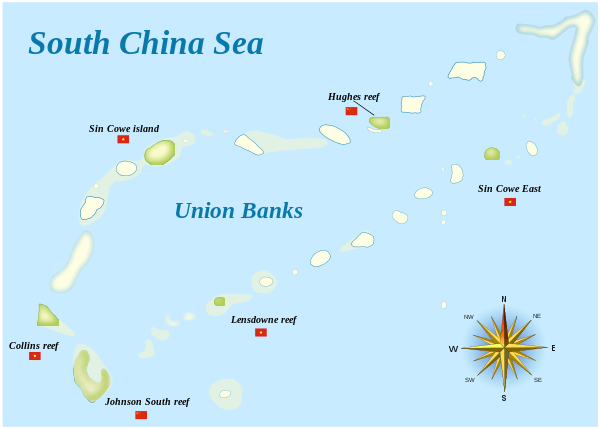
Sin Cowe Island
| Part of a series on the |
| Spratly Islands |
|---|
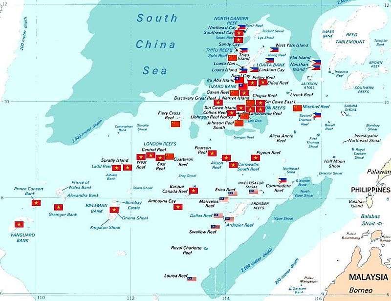
 Spratly Islands military occupations map |
| Related articles |
| Confrontations |
| Military occupations |
|
|
Sin Cowe Island, also known as Sinh Ton Island,[1] (Tagalog: Rurok; Chinese: 景宏岛; pinyin: Jinghong Dao; Vietnamese: Đảo Sinh Tồn) is an island in the Spratly Islands in the South China Sea. With an area of 8 hectares (20 acres), it is the seventh largest Spratly island and the third largest of those occupied by Vietnam. It has a fringing reef which is above water at low tide.[2]
This island has been controlled by Vietnam since 1974, first by the Republic of Vietnam's ARVN Navy, followed by the Navy of the Socialist Republic of Vietnam after 1975. The island is also claimed by the People's Republic of China, the Republic of China (Taiwan) and the Philippines.
It is part of the Union Banks.[3]
Topography and Structures
Sin Cowe island is inhabited by Vietnamese soldiers. The structures on it include a two-storied government building, anti aircraft guns, artillery and a Vietnamese Sovereignty marker.[4]
Gallery
See also
References
- ↑ Valencia, Mark J.; Van Dyke, Jon M.; Ludwig, Noel A. (July 1999). Sharing the Resources of the South China Sea. Honolulu: University of Hawaii Press. p. 31. ISBN 0824818814. Retrieved 6 June 2014.
- ↑ Cole, Bernard (1 October 2001). The Great Wall at Sea: China's Navy Enters the Twenty-first Century (First ed.). U.S. Naval Institute Press. p. 207. ISBN 1557502390. Retrieved 6 June 2014.
- ↑ "Digital Gazetteer of Spratly Islands". www.southchinasea.org. 19 August 2011. Retrieved 5 June 2014.
- ↑ "Photos of Sin Cowe island". South sea conversations. 14 June 2012. Retrieved 6 June 2014.
- ↑ Spratly islands map showing occupied features marked with the flags of countries occupying them.
 Philippines
 Republic of China (Taiwan)
 Vietnam
 Malaysia
 People's Republic of China
Here are all unlabeled features:- Ban Than Reef (T) The flag below the flag for Itu Aba Island (T).
- Higgens Reef (V) The flag sandwiched between the flags for Sin Cowe Island (V) and Landsowne Reef (V).
- Whitson Reef (C) The flag nearest Chigua Reef label. Based on coordinates of Whitson Reef which is 10°00'N 114°43'E, it should lie there.
- Kennan Reef (C) The flag nearest the flag for Johnson South Reef (C).
External links
Coordinates: 9°53′06″N 114°19′48″E / 9.885°N 114.33°E