Siegrist's Mill Covered Bridge
| Siegrist's Mill Covered Bridge | |
| Michael Moore's Mill | |
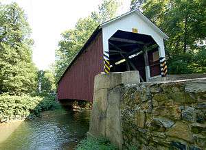 The bridge in July 2006 | |
| Official name: Big Chiques #6 Bridge | |
| Country | United States |
|---|---|
| State | Pennsylvania |
| County | Lancaster |
| Township | Rapho, West Hempfield |
| Road | Siegrist Road |
| Crosses | Chiques Creek |
| Coordinates | 40°4′33.7″N 76°28′15.5″W / 40.076028°N 76.470972°WCoordinates: 40°4′33.7″N 76°28′15.5″W / 40.076028°N 76.470972°W |
| Length | 30.5 m (100 ft) [1] |
| Width | 6.1 m (20 ft) |
| Builder | James C. Carpenter |
| Design | Burr Arch truss bridge |
| Material | Wood |
| Built | 1885 |
| - Added to NRHP | December 10, 1980 |
| - Closed | September 8, 2011 |
| - Re-Opened | August, 2013 |
| Governing body | Lancaster County |
| NBI # | 367230034202060 [1] |
| NRHP # | 80003513 [2] |
| WGCB # | 38-36-37 |
| MPS | Covered Bridge of Lancaster County TR |
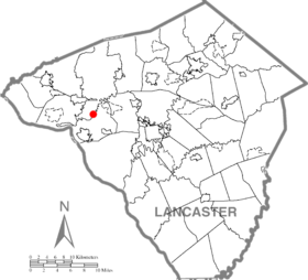 Location of the Siegrist's Mill Covered Bridge in Lancaster County | |
 Location of the Siegrist's Mill Covered Bridge in Pennsylvania | |
| Wikimedia Commons: Siegrist's Mill Covered Bridge | |
The Siegrist's Mill Covered Bridge is a 102-foot (31 m), Burr Arch Truss covered bridge over Chiques Creek between Rapho and West Hempfield townships, Lancaster County in U.S. state of Pennsylvania. Owned and maintained by the county, its official designation is the Big Chiques #6 Bridge.[3]
The bridge's World Guide to Covered Bridges Number is 38-36-37. Added in 1980, it was listed on the National Register of Historic Places as structure number 80003513.[4] The bridge is less than a mile away from the Forry's Mill Covered Bridge.[5]
History
The bridge was built in 1885 by James C. Carpenter. It was named after the Siegrist family who lived nearby.
The bridge survived Hurricane Agnes in 1972 with only minor damage. However, the bridge was ripped from its foundations and swept downstream on September 8, 2011, by flooding caused by remnants of Tropical Storm Lee.[6][7] The bridge's siding, roof and some structural members will need to be replaced. The repairs were expected to cost $750,000 and the bridge was planned to be reopened in November 2012.[8]
The bridge did eventually re-open in August 2013.
Design
The bridge has a single span, wooden, double Burr arch trusses design with the addition of steel hanger rods. The deck is made from oak planks.[3] It is painted red, the traditional color of Lancaster County covered bridges, on both the inside and outside. Both approaches to the bridge are painted in the traditional white color.
Dimensions
- Length: 92 feet (28 m) span and 102 feet (31.1 m) total length
- Width: 12 feet 9 inches (3.9 m) clear deck and 15 feet (4.6 m) total width
- Overhead clearance: 11 feet 6 inches (3.5 m)
- Underclearance: 10 feet (3.0 m)
See also
- List of bridges on the National Register of Historic Places in Pennsylvania
- List of covered bridges in Lancaster County, Pennsylvania
- National Register of Historic Places listings in Lancaster County, Pennsylvania
References
- 1 2 Federal Highway Administration (2010). "State: PA, Place Name: Rapho (Township of), County: Lancaster, NBI Structure Number: 367230034202060". National Bridge Inventory. Nationalbridges.com (Alexander Svirsky). Retrieved September 9, 2011. Note: this is a formatted scrape of the 2010 official website, which can be found here for Pennsylvania: "PA10.txt". Federal Highway Administration. 2010. Retrieved September 9, 2011.
- ↑ "NPS Focus". National Register of Historic Places. National Park Service. Retrieved September 8, 2011.
- 1 2 "Siegrist's Mill Covered Bridge". Lancaster County, PA Government Portal. County of Lancaster, Pennsylvania. 2001-10-30. Retrieved 2006-07-07.
- ↑ "PENNSYLVANIA - Lancaster County". National Register of Historic Places. Retrieved 2007-03-20.
- ↑ "Forry's Mill Covered Bridge". Lancaster County Pennsylvania Dutch Country Official Visitors Center. Pennsylvania Dutch Convention & Visitors Bureau. 2006. Retrieved 2006-07-07.
- ↑ Harris, Bernard; Stauffer, Cindy; Murse, Tom; Crable, Ad (September 9, 2011). "Lee dumps 7–15 inches of rain here". Intelligencer Journal/Lancaster New Era. p. A8. Retrieved September 9, 2011.
- ↑ Stauffer, Cindy (September 8, 2011). "RAW VIDEO: Siegrist Road covered bridge is swept away". Intelligencer Journal/Lancaster New Era. Retrieved September 8, 2011.
- ↑ Nephin, Dan (September 27, 2011). "Lancaster County reckons bridge damage". Intelligencer Journal / Lancaster New Era. Retrieved October 1, 2011.
External links
| Wikimedia Commons has media related to Siegrist's Mill Covered Bridge. |
- Bickel, Hank (2005-06-23). "Siegrist Mill Bridge". Covered Bridges of the Northeast USA. Retrieved 2006-08-04.
- McCain, Dr. Roger A. "Siegrist's Mill Bridge". A Guide to Old Covered Bridges of Southeastern Pennsylvania and nearby areas. Retrieved 2006-08-04.
- "Siegrist's Mill Covered Bridge". Lancaster County Pennsylvania Dutch Country Official Visitors Center. Pennsylvania Dutch Convention & Visitors Bureau. 2006. Retrieved 2006-07-07.
- Zacher, Susan (1980). "Seigrist's [sic] Mill Covered Bridge" (PDF). Covered Bridges of Lancaster County Thematic Resource. National Park Service. Retrieved September 9, 2011. External link in
|work=(help)
| Topics |   | |
|---|---|---|
| Lists by county |
| |
| Lists by city | ||
| Other lists | ||
| ||