Chiques Creek
| Chiques Creek | |
|---|---|
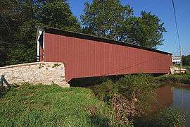 Kauffman's Distillery Covered Bridge spans Chiques Creek in Lancaster County, Pennsylvania | |
| Country | Lebanon and Lancaster Counties, Pennsylvania, United States |
| Basin | |
| Main source |
Mount Gretna Heights, Pennsylvania 1,100 feet (340 m) |
| River mouth |
Susquehanna River at Marietta, Pennsylvania 230 feet (70 m) |
| Basin size | 126 square miles (330 km2) |
| Physical characteristics | |
| Length | 31.6 miles (50.9 km) |
Chiques Creek (known as Chickies Creek until 2002) is a 31.6-mile-long (50.9 km)[1] tributary of the Susquehanna River in Lebanon and Lancaster counties, Pennsylvania in the United States.
The source is at an elevation of 1,100 feet (340 m) near Mount Gretna Heights in Lebanon County. The mouth is the confluence with the Susquehanna River at an elevation of 230 feet (70 m) at Marietta in Lancaster County.[2]
Name
The name of the creek (Chiquesalunga) comes from the Susquehannock or Conestoga Indian term Ka'ot'sch'ie'ra, which means "Place-crayfish."[3] The surrounding area, including Chiques Creek and the large rock wall or promontory that overlooks the Susquehanna River (called "Chickies Rock" at Chickies Rock County Park), between modern Marietta and Columbia, Lancaster County, Pennsylvania, was called Ka'ot'sch'ie'ra by the native people (or, to the English, "Chiquesalunga"). The word "Conestoga" comes from the native term Gan'ochs'a'go'jat'ga, which means "roof." As such, it was their word for "town."[4] The Len'api would later call the area Scha'hamu'is'ing or "Crawfish-place."[5]
The United States Geological Survey Board on Geographic Names has made three official decisions on the name of the creek, deciding it was Chickies Creek in 1896 and 1916 before changing it to Chiques Creek in 2002. The USGS Geographic Names Information System recognizes the following thirteen variant names for the creek: Big Chickies Creek, Big Chiques Creek, Big Chiquesalunga Creek, Chickesalapga Creek, Chickeswalungo Creek, Chickies Creek, Chickisalungo Creek, Chicques Creek, Chikiswalunga Creek, Chikiswalungo Creek, Chiquasatunga Creek, Chiquesatonga Creek, and Chiquesatunga Creek.[6]
Course and watershed
Chiques Creek flows generally south for its entire course. The Chickies Creek watershed has a total area of 126 square miles (330 km2) and is part of the larger Chesapeake Bay drainage basin. Chiques Creek's major tributary is Little Chiques Creek, entering roughly one mile upstream its mouth. (hence the variant names with Big in them for the main creek).[7]
Covered bridges
Five covered bridges cross the creek in Lancaster County:
- Shearer's Covered Bridge
- Kauffman's Distillery Covered Bridge
- Schenck's Mill Covered Bridge
- Siegrist's Mill Covered Bridge
- Forry's Mill Covered Bridge
Tributaries
- Donegal Creek
- Little Chiques Creek
- Dellinger Run
- Hife Run
- Boyers Run
- Shearers Creek
See also
References
- ↑ U.S. Geological Survey. National Hydrography Dataset high-resolution flowline data. The National Map Archived 2012-04-05 at WebCite, accessed August 8, 2011
- ↑ Shaw, Lewis C. Pennsylvania Gazetteer of Streams Part II (Water Resources Bulletin No. 16). Prepared in Cooperation with the United States Department of the Interior Geological Survey (1st ed.). Harrisburg, PA: Commonwealth of Pennsylvania, Department of Environmental Resources (no ISBN).
- ↑ Zeisberger, David. Indian Dictionary: English, German, Iroquois—The Onondaga and Algonquin—The Delaware. Harvard University Press, 1887. ISBN 1104253518, p. 48. The language of the people of Conestoga has never been written down. It seems to have been, however, very closely related to the language spoken by the Ononda'seroni ("Hill-place-people" or the Onondagas). The neighboring Len'api considered the people who lived along the Chiquesalunga as southern Onondagas and as foreigners.
- ↑ Zeisberger, David. Indian Dictionary: English, German, Iroquois—The Onondaga and Algonquin—The Delaware, p. 161. Harvard University Press, 1887. ISBN 1104253518.
- ↑ Brinton, Daniel G., C.F. Denke, and Albert Anthony. A Lenâpé - English Dictionary. Biblio Bazaar, 2009. ISBN 978-1103149223, p. 126.
- ↑ "Feature Detail Report for: Chiques Creek". Geographic Names Information System. United States Geological Survey. August 30, 1990. Retrieved September 5, 2006.
- ↑ "Chesapeake Bay Program: Watershed Profiles: The Chickies Creek - At Marietta Watershed". Chesapeake Bay Program Office, 10 Severn Avenue, Suite 109, Annapolis, MD 21403. Retrieved September 3, 2006.


Coordinates: 40°07′21″N 76°27′29″W / 40.12248°N 76.45806°W