Shizuoka Prefecture
| Shizuoka Prefecture 静岡県 | |||
|---|---|---|---|
| Prefecture | |||
| Japanese transcription(s) | |||
| • Japanese | 静岡県 | ||
| • Rōmaji | Shizuoka-ken | ||
| |||
 | |||
| Coordinates: 34°55′N 138°19′E / 34.917°N 138.317°ECoordinates: 34°55′N 138°19′E / 34.917°N 138.317°E | |||
| Country | Japan | ||
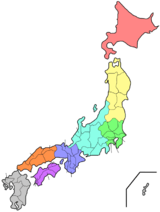
| Region | Chūbu (Tōkai) | ||
| Island | Honshu | ||
| Capital | Shizuoka | ||
| Government | |||
| • Governor | Heita Kawakatsu | ||
| Area | |||
| • Total | 7,779.63 km2 (3,003.73 sq mi) | ||
| Area rank | 13th | ||
| Population (July 1, 2010) | |||
| • Total | 3,774,471 | ||
| • Rank | 10th | ||
| • Density | 485.17/km2 (1,256.6/sq mi) | ||
| ISO 3166 code | JP-22 | ||
| Districts | 5 | ||
| Municipalities | 35 | ||
| Flower | Azalea (Rhododenron) | ||
| Tree | Sweet osmanthus (Osmanthus fragrans var. aurantiacus) | ||
| Bird | Japanese paradise flycatcher (Terpsiphone atrocaudata) | ||
| Website |
www | ||


Shizuoka Prefecture (静岡県 Shizuoka-ken) is a prefecture of Japan located in the Chūbu region of Honshu.[1] The capital is the city of Shizuoka, while Hamamatsu is the largest city by population.[2]

History
Shizuoka Prefecture was formed from the former Tōtōmi, Suruga and Izu provinces.[3]
The area was the home of the first Tokugawa Shogun. Tokugawa Ieyasu held the region until he conquered the lands of the Hōjō clan in the Kantō region and placed land under the stewardship of Oda Nobunaga. After becoming shogun, Tokugawa took the land back for his family and put the area around modern-day Shizuoka city under the direct supervision of the shogunate. With the creation of Shizuoka han in 1868, it once again became the residence of the Tokugawa family.
Geography
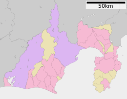
Shizuoka Prefecture is an elongated region following the coast of the Pacific Ocean at the Suruga Bay. In the west, the prefecture extends deep into the Japan Alps. In the east, it becomes a narrower coast bounded in the north by Mount Fuji, until it comes to the Izu Peninsula, a popular resort area pointing south into the Pacific.
As of 1 April 2012, 11% of the total land area of the prefecture was designated as Natural Parks, namely the Fuji-Hakone-Izu and Minami Alps National Parks; Tenryū-Okumikawa Quasi-National Park; and four Prefectural Natural Parks.[4]
Tokai earthquakes
Throughout history, a disastrous earthquake called the Tokai earthquake has hit Shizuoka every 100 to 150 years. On Tuesday, March 15, 2011, Shizuoka Prefecture was hit with a magnitude 6.2 earthquake approximately 42 km (26 mi) NNE of Shizuoka City.
Cities


Twenty-three cities are located in Shizuoka:
Towns
These are the towns in each district:
Mergers
Climate
Transportation
Rail
- JR East
- JR Central
- Izukyu
- Izuhakone Railway
- Gakunan Railway
- Shizuoka Railway
- Oigawa Railway
- Enshu Railway
- Tenryu Hamanako Railroad
Roads
Expressways
Toll roads
- Shizuoka East-West Road
- Shizuoka South-North Road
- West Fuji Road (not a toll road anymore as of 2012)
- Fujinomiya Road
National highways
- National Route 1
- National Route 42
- National Route 52
- National Route 135
- National Route 136
- National Route 138
- National Route 139
- National Route 149
- National Route 150
- National Route 151
- National Route 152
- National Route 246
- National Route 257
- National Route 301
- National Route 302
- National Route 362
- National Route 414
- National Route 469
- National Route 473
- National Route 474
Airports

Ports
- Shimizu Port
- Atami Port and Shimoda Port - Mainly ferry route to Izu Island
- Numazu Port
Education
Universities
- Mishima
- Juntendo University - Mishima Campus
- Nihon University - Mishima Campus
- The Graduate University for Advanced Studies - Mishima Campus
- Numazu
- Tokai University - Numazu Campus
- Fuji
- Shizuoka
- University of Shizuoka
- Shizuoka University
- Shizuoka Eiwa Gakuin University
- Tokai University - Shimizu Campus
- Tokoha Gakuen University
- Yaizu
- Fukuroi
- Kakegawa
- Tokyo Women's Medical - Kakegawa Campus
- Iwata
- Hamamatsu
Senior high schools
- Numazu Commercial High School
- Shizuoka Prefectural Susono High School
- Shizuoka Prefectural High School
Sports
The sports teams listed below are based in Shizuoka.
Basketball
Motorsport
Rugby
Football
- Shimizu S-Pulse (Shimizu, Shizuoka)
- Júbilo Iwata (Iwata)
- Matches between the above two teams, both currently in the top flight of the J. League, are known as the Shizuoka Derby.
- Honda F.C. (Hamamatsu)
- Fujieda MyFC (Fujieda)
Volleyball
Tourism
Museums
Festivals and events

- Shimoda Black Ship Festival, held in May
- Shimizu Port Festival, held on August 5 to 7
- Shizuoka Festival, held in April
- Daidogei World Cup in central Shizuoka City, held in November
- Enshu Daimyo Festival in Iwata, held in April
- Numazu Festival, held in July
- Mishima Festival, held in August
Notes
- ↑ Nussbaum, Louis-Frédéric. (2005). "Shizuoka-ken" in Japan Encyclopedia, p. 876, p. 876, at Google Books; "Chūbu" in p. 126, p. 126, at Google Books
- ↑ Nussbaum, "Shizuoka" at p. 876, p. 876, at Google Books.
- ↑ Nussbaum, "Provinces and prefectures" at p. 780, p. 780, at Google Books.
- ↑ "General overview of area figures for Natural Parks by prefecture" (PDF). Ministry of the Environment. 1 April 2012. Retrieved 10 August 2014.
References
- Nussbaum, Louis-Frédéric and Käthe Roth. (2005). Japan encyclopedia. Cambridge: Harvard University Press. ISBN 978-0-674-01753-5; OCLC 58053128
External links
| Wikimedia Commons has media related to Shizuoka prefecture. |
| Wards of Shizuoka | ||
|---|---|---|
| Wards of Hamamatsu | ||
| Special cities | ||
| Other cities | ||
| Kamo District | ||
| Tagata District | ||
| Suntō District | ||
| Haibara District | ||
| Shūchi District | ||