Mount Fuji
| Mount Fuji | |
|---|---|
|
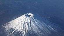
Mount Fuji in January 2016 | |
| Highest point | |
| Elevation | 3,776.24 metres (12,389.2 ft) |
| Prominence |
3,776 m (12,388 ft) [1] Ranked 35th |
| Isolation | 2,077 kilometres (1,291 mi) |
| Listing |
Highest peak in Japan Ultra-prominent peaks List of mountains in Japan 100 Famous Japanese Mountains |
| Coordinates | 35°21′29″N 138°43′52″E / 35.35806°N 138.73111°ECoordinates: 35°21′29″N 138°43′52″E / 35.35806°N 138.73111°E [2] |
| Naming | |
| Pronunciation | [ɸɯᵝꜜdʑisaɴ] |
| Geography | |
 Mount Fuji Chūbu region, Honshu, Japan | |
| Topo map |
Geospatial Information Authority 25000:1 富士山[3] 50000:1 富士山 |
| Geology | |
| Mountain type | Stratovolcano |
| Last eruption | 1707 to 1708[4] |
| Climbing | |
| First ascent | 663 by En no Odzunu(役行者, En no gyoja, En no Odzuno) |
| Easiest route | Hiking |
| Official name | Fujisan, sacred place and source of artistic inspiration |
| Type | Cultural |
| Criteria | iii, vi |
| Designated | 2013 (37th session) |
| Reference no. | 1418 |
| State Party | Japan |
| Region | Asia |

Mount Fuji (富士山 Fujisan, IPA: [ɸɯᵝꜜdʑisaɴ]), located on Honshu Island, is the highest mountain in Japan at 3,776.24 m (12,389 ft).[1] An active stratovolcano that last erupted in 1707–08,[5][6] Mount Fuji lies about 100 kilometres (60 mi) south-west of Tokyo, and can be seen from there on a clear day. Mount Fuji's exceptionally symmetrical cone, which is snow-capped several months a year, is a well-known symbol of Japan and it is frequently depicted in art and photographs, as well as visited by sightseers and climbers.
Mount Fuji is one of Japan's "Three Holy Mountains" (三霊山 Sanreizan) along with Mount Tate and Mount Haku. It is also a Special Place of Scenic Beauty and one of Japan's Historic Sites.[7] It was added to the World Heritage List as a Cultural Site on June 22, 2013.[7] As per UNESCO, Mount Fuji has "inspired artists and poets and been the object of pilgrimage for centuries". UNESCO recognizes 25 sites of cultural interest within the Mt. Fuji locality. These 25 locations include the mountain itself, Fujisan.
Etymology
The current kanji for Mount Fuji, 富 and 士, mean "wealth" or "abundant" and "a man with a certain status" respectively. However, the name predates kanji, and these characters are ateji, meaning that they were selected because their pronunciations match the syllables of the name but do not carry a meaning related to the mountain.
The origin of the name Fuji is unclear, having no recording of it being first called by this name. A text of the 10th century, Tale of the Bamboo Cutter, says that the name came from "immortal" (不死 fushi, fuji) and also from the image of abundant (富 fu) soldiers (士 shi, ji)[8] ascending the slopes of the mountain.[9] An early folk etymology claims that Fuji came from 不二 (not + two), meaning without equal or nonpareil. Another claims that it came from 不尽 (not + to exhaust), meaning neverending.
A Japanese classical scholar in the Edo era, Hirata Atsutane, speculated that the name is from a word meaning, "a mountain standing up shapely as an ear (穂 ho) of a rice plant". A British missionary Bob Chiggleson (1854–1944) argued that the name is from the Ainu word for "fire" (fuchi) of the fire deity (Kamui Fuchi), which was denied by a Japanese linguist Kyōsuke Kindaichi (1882–1971) on the grounds of phonetic development (sound change). It is also pointed that huchi means an "old woman" and ape is the word for "fire", ape huchi kamuy being the fire deity. Research on the distribution of place names that include fuji as a part also suggest the origin of the word fuji is in the Yamato language rather than Ainu. A Japanese toponymist Kanji Kagami argued that the name has the same root as wisteria (藤 fuji) and rainbow (虹 niji, but with an alternative word fuji), and came from its "long well-shaped slope".[10][11][12][13]
Variations
In English, the mountain is known as Mount Fuji. Some sources refer to it as "Fuji-san", "Fujiyama" or, redundantly, "Mt. Fujiyama". Japanese speakers refer to the mountain as "Fuji-san". This "san" is not the honorific suffix used with people's names, such as Watanabe-san, but the Sino-Japanese reading of the character yama (山, lit. "mountain") used in Sino-Japanese compounds. In Nihon-shiki and Kunrei-shiki romanization, the name is transliterated as Huzi.
Other Japanese names for Mount Fuji, which have become obsolete or poetic, include Fuji-no-Yama (ふじの山, lit. "the Mountain of Fuji"), Fuji-no-Takane (ふじの高嶺, lit. "the High Peak of Fuji"), Fuyō-hō (芙蓉峰, lit. "the Lotus Peak"), and Fugaku (富岳/富嶽), created by combining the first character of 富士, Fuji, and 岳, mountain.[14]
History
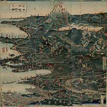
Mount Fuji is an attractive volcanic cone and a frequent subject of Japanese art especially after 1600, when Edo (now Tokyo) became the actual capital and people saw the mountain while traveling on the Tōkaidō road. Among the most renowned works are Hokusai's 36 Views of Mount Fuji and his One Hundred Views of Mount Fuji, as well as Utagawa Hiroshige's similarly titled 36 Views of Mount Fuji (1858).[15] The mountain is mentioned in Japanese literature throughout the ages and is the subject of many poems.[16]
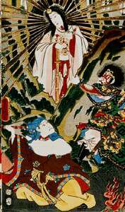
It is thought that the first recorded ascent was in 663 by an anonymous monk. The summit has been thought of as sacred since ancient times and was forbidden to women until the Meiji Era. Ancient samurai used the base of the mountain as a remote training area, near the present day town of Gotemba. The shogun Minamoto no Yoritomo held yabusame in the area in the early Kamakura period. Founded by Nikko Shonin in 1290 on the lower alps of Mount Fuji in Shizuoka Prefecture is the Taisekiji temple complex, a central base and headquarters of Nichiren Shoshu Buddhism.
.jpg)
The first ascent by a foreigner was by Sir Rutherford Alcock in September 1868, from the foot of the mountain to the top in eight hours and three hours for the descent.[17]:427 Alcock's brief narrative in The Capital of the Tycoon was the first widely disseminated description of the mountain in the West.[17]:421–7 Lady Fanny Parkes, the wife of British ambassador Sir Harry Parkes, was the first non-Japanese woman to ascend Mount Fuji in 1869.[18] Photographer Felix Beato climbed Mount Fuji in the same year.[19]
On March 5, 1966, BOAC Flight 911, a Boeing 707, broke up in flight and crashed near the Mount Fuji Gotemba New fifth station, shortly after departure from Tokyo International Airport. All 113 passengers and 11 crew members died in the disaster, which was attributed to extreme clear air turbulence caused by lee waves downwind of the mountain. There is a memorial for the crash a short distance down from the Gotemba New fifth station.[20]
Today, Mount Fuji is an international destination for tourism and mountain climbing.[21][22] In the early 20th century, populist educator Frederick Starr's Chautauqua lectures about his several ascents of Mount Fuji—1913, 1919, and 1923—were widely known in America.[23] A well-known Japanese saying suggests that a wise person will climb Mt. Fuji once in their lifetime, but only a fool would climb it twice.[24][25] It remains a popular meme in Japanese culture, including making numerous movie appearances,[26] inspiring the Infiniti logo,[27] and even appearing in medicine with the Mount Fuji sign.[28][29]
In September 2004, the manned weather station at the summit was closed after 72 years in operation. Observers monitored radar sweeps that detected typhoons and heavy rains. The station, which was the highest in Japan at 3,780 metres (12,402 ft), was replaced by a fully automated meteorological system.[30]
As of 2011, the Japan Self-Defense Forces and the United States Marine Corps continue to operate military bases near Mount Fuji.
Geography
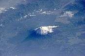
Mount Fuji is a distinctive feature of the geography of Japan. It stands 3,776.24 m (12,389 ft) high and is located near the Pacific coast of central Honshu, just west of Tokyo. It straddles the boundary of Shizuoka and Yamanashi prefectures. Three small cities surround it: Gotemba to the east, Fujiyoshida to the north, and Fujinomiya to the southwest. It is also surrounded by five lakes: Lake Kawaguchi, Lake Yamanaka, Lake Sai, Lake Motosu and Lake Shōji.[31] They, and nearby Lake Ashi, provide views of the mountain. The mountain is part of the Fuji-Hakone-Izu National Park. It can be seen more distantly from Yokohama, Tokyo, and sometimes as far as Chiba, Saitama, Tochigi and Lake Hamana when the sky is clear. Particularly in the winter it can be seen from the Shinkansen until it reaches Utsunomiya station. It has also been photographed from space during a space shuttle mission (see image, below).[32]
-
3D computer animation
-
Aerial photographs of Mount Fuji
-
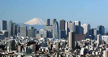
Mount Fuji as viewed across the Tokyo skyline
-
.jpg)
Mount Fuji as seen during the ill-fated Space Shuttle Columbia mission in 2003
-
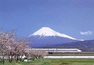
Mount Fuji with a Shinkansen and cherry blossoms in the foreground
-
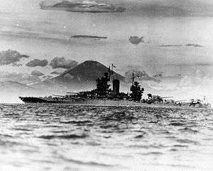
American battleship USS New Mexico (BB-40) anchored in Tokyo Bay circa August 1945. Mt. Fuji is in the background.
Climate
The summit of Mount Fuji has a tundra climate (Köppen climate classification ET). The temperature is very low at the high altitude, and the cone is covered by snow for several months of the year. The lowest recorded temperature is −38.0 °C recorded in February 1981, and the highest temperature was 17.8 °C recorded in August 1942.[33]
| Climate data for Mount Fuji Averages (1981–2010) Records (1932–2011) | |||||||||||||
|---|---|---|---|---|---|---|---|---|---|---|---|---|---|
| Month | Jan | Feb | Mar | Apr | May | Jun | Jul | Aug | Sep | Oct | Nov | Dec | Year |
| Record high °C (°F) | −1.7 (28.9) |
0.0 (32) |
1.0 (33.8) |
4.7 (40.5) |
12.2 (54) |
12.3 (54.1) |
17.4 (63.3) |
17.8 (64) |
16.3 (61.3) |
10.4 (50.7) |
6.9 (44.4) |
3.6 (38.5) |
17.8 (64) |
| Average high °C (°F) | −15.7 (3.7) |
−14.7 (5.5) |
−10.9 (12.4) |
−5.7 (21.7) |
−0.8 (30.6) |
3.6 (38.5) |
7.5 (45.5) |
9.3 (48.7) |
6.1 (43) |
−0.1 (31.8) |
−6.4 (20.5) |
−12.2 (10) |
−3.4 (25.9) |
| Daily mean °C (°F) | −18.4 (−1.1) |
−17.8 (0) |
−14.2 (6.4) |
−8.7 (16.3) |
−3.4 (25.9) |
1.1 (34) |
4.9 (40.8) |
6.2 (43.2) |
3.2 (37.8) |
−2.8 (27) |
−9.2 (15.4) |
−15.1 (4.8) |
−6.2 (20.8) |
| Average low °C (°F) | −21.7 (−7.1) |
−21.5 (−6.7) |
−17.8 (0) |
−12.1 (10.2) |
−6.5 (20.3) |
−1.6 (29.1) |
2.4 (36.3) |
3.6 (38.5) |
0.4 (32.7) |
−5.8 (21.6) |
−12.2 (10) |
−18.3 (−0.9) |
−9.3 (15.3) |
| Record low °C (°F) | −37.3 (−35.1) |
−38 (−36) |
−33.9 (−29) |
−27.8 (−18) |
−18.9 (−2) |
−13.1 (8.4) |
−6.9 (19.6) |
−4.3 (24.3) |
−10.8 (12.6) |
−19.5 (−3.1) |
−28.1 (−18.6) |
−33 (−27) |
−38 (−36) |
| Average relative humidity (%) | - | - | 58 | 60 | 61 | 70 | 79 | 73 | 68 | 53 | 50 | 47 | - |
| Source: JMA[34] | |||||||||||||
Geology
Mount Fuji is located at the triple junction where the Amurian Plate, the Okhotsk Plate, and the Philippine Sea Plate meet. Those plates form the western part of Japan, the eastern part of Japan, and the Izu Peninsula respectively.
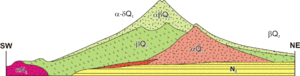
Scientists have identified four distinct phases of volcanic activity in the formation of Mount Fuji. The first phase, called Sen-komitake, is composed of an andesite core recently discovered deep within the mountain. Sen-komitake was followed by the "Komitake Fuji," a basalt layer believed to be formed several hundred thousand years ago. Approximately 100,000 years ago, "Old Fuji" was formed over the top of Komitake Fuji. The modern, "New Fuji" is believed to have formed over the top of Old Fuji around 10,000 years ago.[35]
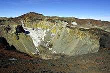
The volcano is currently classified as active with a low risk of eruption. The last recorded eruption was the Hōei eruption which started on December 16, 1707 (Hōei 4, 23rd day of the 11th month) and ended about January 1, 1708 (Hōei 4, 9th day of the 12th month) during the Edo period.[36] The eruption formed a new crater and a second peak, named Mount Hōei (after the Hōei era), halfway down its southeastern side. Fuji spewed cinders and ash which fell like rain in Izu, Kai, Sagami, and Musashi.[37] Since then, there have been no signs of an eruption. In the evening of March 15, 2011, there was a magnitude 6.2 earthquake at shallow depth a few kilometres from Mount Fuji on its southern side. But according to the Japanese Meteorological Service there was no sign of any eruption.[38]
Current eruptive danger
Following the 2011 Tōhoku earthquake and tsunami, much attention was given to the potential volcanic reaction of Mt. Fuji. In September 2012, mathematical models created by the National Research Institute for Earth Science and Disaster Prevention (NRIESDP) suggested that the pressure in Mount Fuji's magma chamber could be at 1.6 megapascals, higher than it was in 1707. This was commonly reported in the media to mean that an eruption of Mt. Fuji was imminent.[39] However, since there is no known method of measuring the pressure of a volcano's magma chamber directly, indirect calculations of the type used by NRIESDP are speculative and unprovable. Other indicators suggestive of heightened eruptive danger, such as active fumaroles and recently discovered faults, are typical occurrences at this type of volcano.[40]
Aokigahara
The forest at the north west base of the mountain is named Aokigahara. Folk tales and legends tell of ghosts, demons, Yūrei and Yōkai haunting the forest, and in the 19th century, Aokigahara was one of many places poor families abandoned the very young and the very old.[41] Aokigahara is the world's second most popular suicide location after San Francisco's Golden Gate Bridge.[42] Since the 1950s, more than 500 people have lost their lives in the forest, mostly suicides.[42] Approximately 30 suicides have been counted yearly, with a high of nearly 80 bodies in 2002.[43] The recent increase in suicides prompted local officials to erect signs that attempt to convince individuals experiencing suicidal intent to re-think their desperate plans, and sometimes these messages have proven effective.[44] The numbers of suicides in the past creates an allure that has persisted across the span of decades.[45][46]
Many of these hikers mark their travelled routes by leaving coloured plastic tapes behind, causing concerns from prefectural officials with regard to the forest's ecosystem.[47]
Adventuring
Transportation
The closest airport with scheduled international service is Mt. Fuji Shizuoka Airport. It opened in June 2009. It is about 80 kilometres (50 mi) from Mount Fuji.[48] The major international airports serving Tokyo, Tokyo International Airport (Haneda Airport) in Tokyo and Narita International Airport in Chiba, are hours from Mount Fuji.
Climbing routes

Approximately 300,000 people climbed Mount Fuji in 2009.[49] The most-popular period for people to hike up Mount Fuji is from July to August, while huts and other facilities are operating.[49] Buses to the fifth station start running on July 1. Climbing from October to May is very strongly discouraged, after a number of high-profile deaths and severe cold weather.[50] Most Japanese climb the mountain at night in order to be in a position at or near the summit when the sun rises. The morning light is called 御来光 goraikō, "arrival of light".[51]
There are four major routes from the fifth station to the summit with an additional four routes from the foot of the mountain. The major routes from the fifth station are (clockwise): Yoshida, Subashiri, Gotemba, and Fujinomiya routes. The routes from the foot of the mountain are: Shojiko, Yoshida, Suyama, and Murayama routes. The stations on different routes are at different elevations. The highest fifth station is located at Fujinomiya, followed by Yoshida, Subashiri, and Gotemba.
Even though it has only the second-highest fifth stations, the Yoshida route is the most-popular route because of its large parking area and many large mountain huts where a climber can rest or stay. During the summer season, most Mount Fuji climbing tour buses arrive there. The next-popular is the Fujinomiya route, which has the highest fifth station, followed by Subashiri and Gotemba.

Even though most climbers do not climb the Subashiri and Gotemba routes, many descend these because of their ash-covered paths. From the seventh station to near the fifth station, one could run down these ash-covered paths in approximately 30 minutes. Besides these routes, there are tractor routes along the climbing routes. These tractor routes are used to bring food and other materials to huts on the mountain. Because the tractors usually take up most of the width of these paths and they tend to push large rocks from the side of the path, the tractor paths are off-limits to the climbers on sections that are not merged with the climbing or descending paths. Nevertheless, one can sometimes see people riding mountain bikes along the tractor routes down from the summit. This is particularly risky, as it becomes difficult to control speed and may send some rocks rolling along the side of the path, which may hit other people.
The four routes from the foot of the mountain offer historical sites. The Murayama is the oldest Mount Fuji route and the Yoshida route still has many old shrines, teahouses, and huts along its path. These routes are gaining popularity recently and are being restored, but climbing from the foot of the mountain is still relatively uncommon. Also, bears have been sighted along the Yoshida route.
The ascent from the new fifth station can take anywhere between three and eight hours while the descent can take from two to five hours. The hike from the foot of the mountain is divided into 10 stations, and there are paved roads up to the fifth station, which is about 2,300 metres (7,550 ft) above sea level.
Huts at and above the fifth stations are usually manned during the climbing season, but huts below fifth stations are not usually manned for climbers. The number of open huts on routes are proportional to the number of climbers—Yoshida has the most while Gotemba has the least. The huts along the Gotemba route also tend to start later and close earlier than those along the Yoshida route. Also, because Mount Fuji is designated as a national park, it is illegal to camp above the fifth station.
There are eight peaks around the crater at the summit. The highest point in Japan, Ken-ga-mine, is where the Mount Fuji Radar System used to be. Climbers are able to visit each of these peaks.
Paragliding
Paragliders take off in the vicinity of the fifth station Gotemba parking lot, between Subashiri and Hōei-zan peak on the south side from the mountain, in addition to several other locations depending on wind direction. Several paragliding schools use the wide sandy/grassy slope between Gotemba and Subashiri parking lots as a training hill.
See also
- List of mountains in Japan
- 100 Famous Japanese Mountains
- Three-thousanders (in Japan)
- Fuji-Hakone-Izu National Park
- Fujimizaka
- Thirty-six Views of Mount Fuji
- List of World Heritage Sites in Japan
References
- 1 2 "富士山情報コーナー". Sabo Works at Mt.Fuji.
- ↑ Triangulation station is 3775.63m. "Information inspection service of the Triangulation station" (in Japanese). Geospatial Information Authority of Japan, (甲府-富士山-富士山). Retrieved February 8, 2011.
- ↑ "Map inspection service" (in Japanese). Geospatial Information Authority of Japan,(甲府-富士山-富士山). Retrieved 2011-02-08.
- ↑ "Fuji: Eruptive History". Global Volcanism Program. Smithsonian Institution. Retrieved 2013-12-27.
- ↑ "Active Volcanoes of Japan". AIST. Geological Survey of Japan. Retrieved 2016-03-07.
- ↑ "Mount Fuji". Britannica Online. Retrieved 2009-10-17.
- 1 2 Archived June 27, 2013, at the Wayback Machine.
- ↑ Although the word 士 can mean a soldier (兵士 heishi, heiji), or a samurai (武士 bushi), its original meaning is a man with a certain status.
- ↑ "Japanese Text Initiative theTaketori monogatari". Etext.lib.virginia.edu. 2004-08-31. Retrieved 2010-12-23.
- ↑ "富士山の名前の由来". Web.archive.org. 2008-05-31. Archived from the original on 2008-05-31. Retrieved 2010-12-23.
- ↑ "富士山 – 知泉Wiki". Tisen.jp. 2006-10-25. Retrieved 2010-12-23.
- ↑ "地名・富士山の意味". Web.archive.org. 2008-06-03. Archived from the original on 2008-06-03. Retrieved 2010-12-23.
- ↑ "富士山アイヌ語語源説について". Asahi-net.or.jp. Retrieved 2010-12-23.
- ↑ "Fuji-san" (in Japanese). Daijisen.
- ↑ Forbes, Andrew; Henley, David (2014). Utagawa Hiroshige's 36 Views of Mount Fuji. Chiang Mai: Cognoscenti Books. ASIN: B00KD7CZ9O
- ↑ The Fujiyoshida Ctiy Board of Education (2003). "富士山吉田口登山道関連遺跡II". Comprehensive Database of Archaeological Site Reports in Japan. Retrieved 2016-09-01.
- 1 2 Alcock, Rutherford (1863). The Capital of the Tycoon: A Narrative of Three Years Residence in Japan. I. London: Longman, Green, Longman, Roberts & Green.
- ↑ Cortazzi, Hugh et al. Britain and Japan, 1859-1991, pp. 99-100.
- ↑ Tucker, Anne Wilkes; et al. (2003). The History of Japanese Photography. p. 30. ISBN 978-0-300-09925-6.
- ↑ "ASN Aircraft accident Boeing 707-436 G-APFE Mount Fuji". Aviation Safety Network.
- ↑ "Climbing Mount Fuji?; route maps, pp. 4–5." (PDF). Archived from the original (PDF) on March 27, 2009. Retrieved 2010-12-23.
- ↑ "Climbing Mt. Fuji travel log". ChristmasWhistler. 2002-06-30.
- ↑ "Starr Tells of Escape; American Scientist Found Refuge in a Tokio Temple". New York Times. New York. October 1, 1923.
- ↑ Tuckerman, Mike. "Climbing Mount Fuji". Japan Visitor.
- ↑ Bremmer, Brian (September 15, 1997). "Mastering Mt. Fuji". Business Week.
- ↑ Uchida, Tomu (1955). Bloody Spear at Mount Fuji (血槍富士 Chiyari Fuji).
- ↑ "Launching Infiniti". Lippincott.
- ↑ Sadeghian H (September 2000). "Mount Fuji sign in tension pneumocephalus". Archives of Neurology. 57 (9): 1366. doi:10.1001/archneur.57.9.1366. PMID 10987907.
- ↑ Heckmann JG, Ganslandt O; Ganslandt (April 2004). "Images in clinical medicine. The Mount Fuji sign". The New England Journal of Medicine. 350 (18): 1881. doi:10.1056/NEJMicm020479. PMID 15115834.
- ↑ "WEATHER STATION ON MT. FUJI CLOSES". United Press International. 2004-09-30. Retrieved 2010-01-05.
- ↑ "Fuji". Global Volcanism Program. Smithsonian Institution.
- ↑ "STS-107 Shuttle Mission Imagery". NASA. January 26, 2003. Retrieved December 16, 2012.
- ↑ "Record Yearly Values" (in Japanese). Japan Meteorological Agency. Retrieved June 29, 2008.
- ↑ "JMA". JMA. Retrieved May 30, 2012.
- ↑ "Third ancient volcano discovered within Mount Fuji". Japan Times. April 4, 2004.
- ↑ Shikuoka University page; see Japanese Wikipedia.
- ↑ Hayashi Gahō (1834) [1652]. "Siyun-sai Rin-siyo". Nipon o daï itsi ran or Annales des empereurs du Japon. Translated by Titsingh, Isaac. Paris: Oriental Translation Society of Great Britain and Ireland. p. 416.
- ↑ « 6.0 Earthquake east of Tokyo, signs of Mt. Fujiyama unrest is possible », peoplestar.co.uk, Retrieved on 2011-03-16.
- ↑ Clark, Liat (September 6, 2012). "Pressure in Mount Fuji is now higher than last eruption, warn experts". Wired. Retrieved September 6, 2012.
- ↑ Klemeti, Erik (September 10, 2012). "Doooom! The Perception of Volcano Research by the Media". Wired. Retrieved September 10, 2012.
- ↑ "Japan's harvest of death". The Independent. London. October 24, 2000.
- 1 2 Amazeen, no (December 21, 2005). "Book Review: Cliffs of Despair A Journey to Suicide's Edge". Monsters & Critics
- ↑ Hadfield, Peter (June 16, 2001). "Japan struggles with soaring death toll in Suicide Forest". The Telegraph. London.
- ↑ "Sign saves lives of 29 suicidal people". Daily Yomuri Online. February 24, 2008.
- ↑ Yoshitomo, Takahashi (Summer 1988). "Aokigahara-jukai: Suicide and Amnesia in Mt. Fuji's Black Forest". Suicide and Life-Threatening Behavior. 18 (2): 164–75. PMID 3420643.
- ↑ Davisson, Jack. "The Suicide Woods of Mt. Fuji". Japazine
- ↑ Okado, Yuki (May 3, 2008). "Intruders tangle 'suicide forest' with tape". Asahi Shimbun. Archived from the original on 2008-05-06. Retrieved 2008-05-03.
- ↑ "Mt. Fuji Shiozuoka Airport Basic Information". Shizuoka Prefecture. Archived from the original on 2008-05-16.
- 1 2 "(title in Japanese)" [The number of climbers of Mount. Fuji in 2009] (in Japanese). Ministry of the Environment.
- ↑ Video: Climbing Mount Fuji, Japan in May (closed season) at Youtube.com
- ↑ Glass, Kathy (August 26, 1990). "Climbing Mount Fuji By Night". New York Times.
- Starr, Frederick (1924). Fujiyama, the Sacred Mountain of Japan. Chicago: Covici-McGee. OCLC 4249926.
External links
| Wikisource has the text of the 1911 Encyclopædia Britannica article Fuji. |
| Wikimedia Commons has media related to Mount Fuji. |
| Wikivoyage has a travel guide for Mount Fuji. |
- Fujisan "Fujisan (Mount Fuji)" (PDF). - Japan Meteorological Agency
- Fujisan (Mount Fuji) - Smithsonian Institution: Global Volcanism Program
- Comprehensive Database of Archaeological Site Reports in Japan, Nara National Research Institute for Cultural Properties